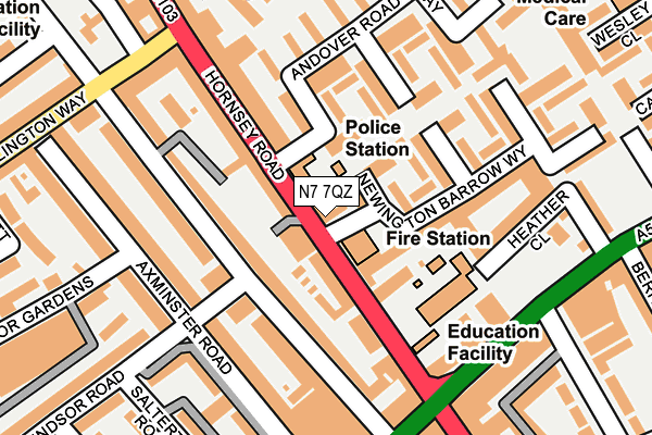
N7 7QZ is located in the Finsbury Park electoral ward, within the London borough of Islington and the English Parliamentary constituency of Islington North. The Sub Integrated Care Board (ICB) Location is NHS North Central London ICB - 93C and the police force is Metropolitan Police. This postcode has been in use since February 1990.


GetTheData
Source: OS OpenMap – Local (Ordnance Survey)
Source: OS VectorMap District (Ordnance Survey)
Licence: Open Government Licence (requires attribution)
| Easting | 530660 |
| Northing | 186446 |
| Latitude | 51.561766 |
| Longitude | -0.116461 |
GetTheData
Source: Open Postcode Geo
Licence: Open Government Licence
| Country | England |
| Postcode District | N7 |
| ➜ N7 open data dashboard ➜ See where N7 is on a map ➜ Where is London? | |
GetTheData
Source: Land Registry Price Paid Data
Licence: Open Government Licence
Elevation or altitude of N7 7QZ as distance above sea level:
| Metres | Feet | |
|---|---|---|
| Elevation | 30m | 98ft |
Elevation is measured from the approximate centre of the postcode, to the nearest point on an OS contour line from OS Terrain 50, which has contour spacing of ten vertical metres.
➜ How high above sea level am I? Find the elevation of your current position using your device's GPS.
GetTheData
Source: Open Postcode Elevation
Licence: Open Government Licence
| Ward | Finsbury Park |
| Constituency | Islington North |
GetTheData
Source: ONS Postcode Database
Licence: Open Government Licence
| January 2024 | Bicycle theft | On or near Hercules Place | 396m |
| January 2024 | Other theft | On or near Hercules Place | 396m |
| January 2024 | Other theft | On or near Hercules Place | 396m |
| ➜ Get more crime data in our Crime section | |||
GetTheData
Source: data.police.uk
Licence: Open Government Licence
| Seven Sisters Road Hornsey Rd | Holloway | 144m |
| Tollington Park Hornsey Road (Hornsey Road) | Holloway | 157m |
| Hornsey Road (N7) | Holloway | 221m |
| Tollington Park Hornsey Road | Holloway | 354m |
| Seven Sisters Nags Head (Seven Sisters Road) | Holloway | 367m |
| Arsenal Underground Station | Arsenal | 714m |
| Finsbury Park Underground Station | Finsbury Park | 719m |
| Holloway Road Underground Station | Holloway Road | 1,033m |
| Archway Underground Station | Archway | 1,338m |
| Caledonian Road Underground Station | Caledonian Road | 1,481m |
| Finsbury Park Station | 0.8km |
| Upper Holloway Station | 0.9km |
| Crouch Hill Station | 1.1km |
GetTheData
Source: NaPTAN
Licence: Open Government Licence
GetTheData
Source: ONS Postcode Database
Licence: Open Government Licence

➜ Get more ratings from the Food Standards Agency
GetTheData
Source: Food Standards Agency
Licence: FSA terms & conditions
| Last Collection | |||
|---|---|---|---|
| Location | Mon-Fri | Sat | Distance |
| Tollington Way | 17:30 | 12:00 | 145m |
| 121 Seven Sisters Road | 17:30 | 12:00 | 250m |
| 352 Hornsey Road/Tollington Pk | 17:30 | 12:00 | 262m |
GetTheData
Source: Dracos
Licence: Creative Commons Attribution-ShareAlike
| Facility | Distance |
|---|---|
| Fitness First Health Club (London Holloway) (Closed) Seven Sisters Road, London Health and Fitness Gym, Studio | 182m |
| Grafton School Eburne Road, London Sports Hall | 341m |
| St Mark's Primary School Sussex Way, Islington, London Artificial Grass Pitch | 357m |
GetTheData
Source: Active Places
Licence: Open Government Licence
| School | Phase of Education | Distance |
|---|---|---|
| Montem Primary School Hornsey Road, Islington, N7 7QT | Primary | 137m |
| Grafton Primary School Eburne Road, Holloway, London, N7 6AR | Primary | 349m |
| Pakeman Primary School Hornsey Road, Holloway, London, N7 6DU | Primary | 371m |
GetTheData
Source: Edubase
Licence: Open Government Licence
The below table lists the International Territorial Level (ITL) codes (formerly Nomenclature of Territorial Units for Statistics (NUTS) codes) and Local Administrative Units (LAU) codes for N7 7QZ:
| ITL 1 Code | Name |
|---|---|
| TLI | London |
| ITL 2 Code | Name |
| TLI4 | Inner London - East |
| ITL 3 Code | Name |
| TLI43 | Haringey and Islington |
| LAU 1 Code | Name |
| E09000019 | Islington |
GetTheData
Source: ONS Postcode Directory
Licence: Open Government Licence
The below table lists the Census Output Area (OA), Lower Layer Super Output Area (LSOA), and Middle Layer Super Output Area (MSOA) for N7 7QZ:
| Code | Name | |
|---|---|---|
| OA | E00174787 | |
| LSOA | E01002731 | Islington 007B |
| MSOA | E02000560 | Islington 007 |
GetTheData
Source: ONS Postcode Directory
Licence: Open Government Licence
| N7 7RF | Mingard Walk | 29m |
| N7 7EE | Tiltman Place | 59m |
| N7 6RA | Hornsey Road | 72m |
| N7 7EF | Tiltman Place | 72m |
| N7 7EG | Tiltman Place | 82m |
| N7 7EN | Tiltman Place | 84m |
| N7 7EH | Tiltman Place | 95m |
| N7 6RT | Sussex Way | 98m |
| N7 7RE | Hanmer Walk | 98m |
| N7 6RZ | Hornsey Road | 103m |
GetTheData
Source: Open Postcode Geo; Land Registry Price Paid Data
Licence: Open Government Licence