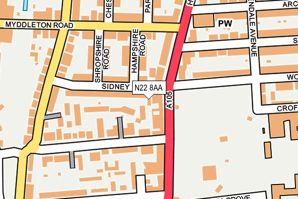
N22 8AA lies on Omega Terrace in London. N22 8AA is located in the Woodside electoral ward, within the London borough of Haringey and the English Parliamentary constituency of Hornsey and Wood Green. The Sub Integrated Care Board (ICB) Location is NHS North Central London ICB - 93C and the police force is Metropolitan Police. This postcode has been in use since January 2015.


GetTheData
Source: OS OpenMap – Local (Ordnance Survey)
Source: OS VectorMap District (Ordnance Survey)
Licence: Open Government Licence (requires attribution)
| Easting | 530817 |
| Northing | 191258 |
| Latitude | 51.604973 |
| Longitude | -0.112406 |
GetTheData
Source: Open Postcode Geo
Licence: Open Government Licence
| Street | Omega Terrace |
| Town/City | London |
| Country | England |
| Postcode District | N22 |
| ➜ N22 open data dashboard ➜ See where N22 is on a map ➜ Where is London? | |
GetTheData
Source: Land Registry Price Paid Data
Licence: Open Government Licence
Elevation or altitude of N22 8AA as distance above sea level:
| Metres | Feet | |
|---|---|---|
| Elevation | 30m | 98ft |
Elevation is measured from the approximate centre of the postcode, to the nearest point on an OS contour line from OS Terrain 50, which has contour spacing of ten vertical metres.
➜ How high above sea level am I? Find the elevation of your current position using your device's GPS.
GetTheData
Source: Open Postcode Elevation
Licence: Open Government Licence
| Ward | Woodside |
| Constituency | Hornsey And Wood Green |
GetTheData
Source: ONS Postcode Database
Licence: Open Government Licence
| December 2023 | Anti-social behaviour | On or near Nightingale Road | 340m |
| November 2023 | Anti-social behaviour | On or near Nightingale Road | 340m |
| October 2023 | Violence and sexual offences | On or near Nightingale Road | 340m |
| ➜ Get more crime data in our Crime section | |||
GetTheData
Source: data.police.uk
Licence: Open Government Licence
| Arcadian Gardens (High Road) | Wood Green | 100m |
| Wood Green Police Station (High Road) | Wood Green | 180m |
| Arcadian Gardens (High Road) | Wood Green | 249m |
| Wood Green Police Station (High Road) | Wood Green | 254m |
| Canning Crescent (High Road) | Wood Green | 355m |
| Bounds Green Underground Station | Wood Green | 851m |
| Wood Green Underground Station | Wood Green | 852m |
| Arnos Grove Underground Station | Arnos Grove | 1,917m |
| Bowes Park Station | 0.6km |
| Alexandra Palace Station | 1km |
| Palmers Green Station | 1.5km |
GetTheData
Source: NaPTAN
Licence: Open Government Licence
GetTheData
Source: ONS Postcode Database
Licence: Open Government Licence


➜ Get more ratings from the Food Standards Agency
GetTheData
Source: Food Standards Agency
Licence: FSA terms & conditions
| Last Collection | |||
|---|---|---|---|
| Location | Mon-Fri | Sat | Distance |
| Marlborough Road/ | 17:30 | 12:00 | 245m |
| Commerce Road | 17:30 | 12:00 | 296m |
| Truro Road | 17:30 | 12:00 | 330m |
GetTheData
Source: Dracos
Licence: Creative Commons Attribution-ShareAlike
| Facility | Distance |
|---|---|
| St Thomas More Catholic School Glendale Avenue, London Health and Fitness Gym, Artificial Grass Pitch, Sports Hall, Studio | 347m |
| White Hart Lane Recreation Ground White Hart Lane, Wood Green, London Grass Pitches | 577m |
| Woodside High School White Hart Lane, London Sports Hall, Grass Pitches, Artificial Grass Pitch, Health and Fitness Gym | 810m |
GetTheData
Source: Active Places
Licence: Open Government Licence
| School | Phase of Education | Distance |
|---|---|---|
| St Thomas More Catholic School Glendale Avenue, Wood Green, London, N22 5HN | Secondary | 257m |
| Earlham Primary School Earlham Grove, Wood Green, London, N22 5HJ | Primary | 323m |
| Haringey Learning Partnership Commerce Road, London, N22 8DZ | Not applicable | 414m |
GetTheData
Source: Edubase
Licence: Open Government Licence
The below table lists the International Territorial Level (ITL) codes (formerly Nomenclature of Territorial Units for Statistics (NUTS) codes) and Local Administrative Units (LAU) codes for N22 8AA:
| ITL 1 Code | Name |
|---|---|
| TLI | London |
| ITL 2 Code | Name |
| TLI4 | Inner London - East |
| ITL 3 Code | Name |
| TLI43 | Haringey and Islington |
| LAU 1 Code | Name |
| E09000014 | Haringey |
GetTheData
Source: ONS Postcode Directory
Licence: Open Government Licence
The below table lists the Census Output Area (OA), Lower Layer Super Output Area (LSOA), and Middle Layer Super Output Area (MSOA) for N22 8AA:
| Code | Name | |
|---|---|---|
| OA | E00009902 | |
| LSOA | E01001969 | Haringey 001A |
| MSOA | E02000397 | Haringey 001 |
GetTheData
Source: ONS Postcode Directory
Licence: Open Government Licence
| N22 8EY | Cameron Close | 46m |
| N22 8JA | High Road | 60m |
| N22 8LS | Sidney Road | 66m |
| N22 8ET | Justin Place | 73m |
| N22 8LT | Sidney Road | 86m |
| N22 8LR | Hampshire Road | 86m |
| N22 8JB | High Road | 89m |
| N22 8EL | Truro Road | 103m |
| N22 8JR | High Road | 111m |
| N22 8LX | Shropshire Road | 124m |
GetTheData
Source: Open Postcode Geo; Land Registry Price Paid Data
Licence: Open Government Licence