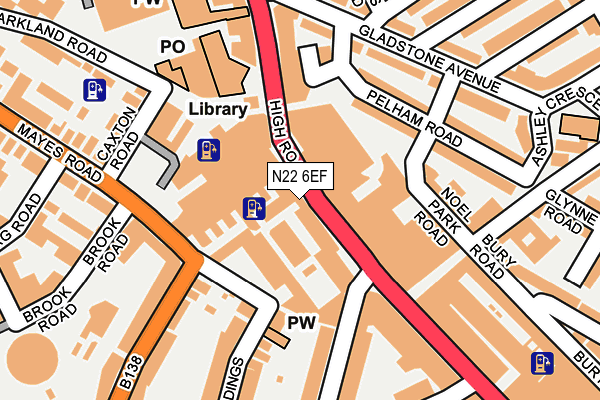
N22 6EF is located in the Noel Park electoral ward, within the London borough of Haringey and the English Parliamentary constituency of Hornsey and Wood Green. The Sub Integrated Care Board (ICB) Location is NHS North Central London ICB - 93C and the police force is Metropolitan Police. This postcode has been in use since January 1980.


GetTheData
Source: OS OpenMap – Local (Ordnance Survey)
Source: OS VectorMap District (Ordnance Survey)
Licence: Open Government Licence (requires attribution)
| Easting | 531111 |
| Northing | 190081 |
| Latitude | 51.594327 |
| Longitude | -0.108602 |
GetTheData
Source: Open Postcode Geo
Licence: Open Government Licence
| Country | England |
| Postcode District | N22 |
| ➜ N22 open data dashboard ➜ See where N22 is on a map ➜ Where is Wood Green? | |
GetTheData
Source: Land Registry Price Paid Data
Licence: Open Government Licence
Elevation or altitude of N22 6EF as distance above sea level:
| Metres | Feet | |
|---|---|---|
| Elevation | 20m | 66ft |
Elevation is measured from the approximate centre of the postcode, to the nearest point on an OS contour line from OS Terrain 50, which has contour spacing of ten vertical metres.
➜ How high above sea level am I? Find the elevation of your current position using your device's GPS.
GetTheData
Source: Open Postcode Elevation
Licence: Open Government Licence
| Ward | Noel Park |
| Constituency | Hornsey And Wood Green |
GetTheData
Source: ONS Postcode Database
Licence: Open Government Licence
| January 2024 | Other theft | On or near Noel Park Road | 133m |
| January 2024 | Vehicle crime | On or near Noel Park Road | 133m |
| January 2024 | Theft from the person | On or near Ashley Crescent | 250m |
| ➜ Get more crime data in our Crime section | |||
GetTheData
Source: data.police.uk
Licence: Open Government Licence
| Wood Green Shopping City | Wood Green | 38m |
| Wood Green Shopping City | Wood Green | 142m |
| Wood Green Station (High Road) | Wood Green | 166m |
| Brampton Park Road (High Road) | Wood Green | 208m |
| Brampton Park Road (Wood Green High Road) | Wood Green | 226m |
| Wood Green Underground Station | Wood Green | 362m |
| Turnpike Lane Underground Station | Turnpike Lane | 597m |
| Bounds Green Underground Station | Wood Green | 1,781m |
| Alexandra Palace Station | 0.9km |
| Hornsey Station | 0.9km |
| Bowes Park Station | 1.6km |
GetTheData
Source: NaPTAN
Licence: Open Government Licence
GetTheData
Source: ONS Postcode Database
Licence: Open Government Licence


➜ Get more ratings from the Food Standards Agency
GetTheData
Source: Food Standards Agency
Licence: FSA terms & conditions
| Last Collection | |||
|---|---|---|---|
| Location | Mon-Fri | Sat | Distance |
| Gladstone Avenue | 17:30 | 12:00 | 212m |
| High Road/Earlham Grove | 17:30 | 12:00 | 313m |
| 69-71 High Road | 17:30 | 12:00 | 339m |
GetTheData
Source: Dracos
Licence: Creative Commons Attribution-ShareAlike
| Facility | Distance |
|---|---|
| The Gym Group (London Wood Green The Mall) High Road, London Health and Fitness Gym, Studio | 76m |
| The Gym Group (London Wood Green Lordship Lane) Lordship Lane, London Health and Fitness Gym | 308m |
| Zone Gym (Wood Green Gym) Coburg Road, Wood Green, London Health and Fitness Gym, Studio | 318m |
GetTheData
Source: Active Places
Licence: Open Government Licence
| School | Phase of Education | Distance |
|---|---|---|
| Noel Park Primary School Gladstone Avenue, Wood Green, London, N22 6LH | Primary | 383m |
| Area 51 Education Ltd 1 Mallard Place, Coburg Road, London, N22 6TS | Not applicable | 407m |
| Alexandra Primary School Western Road, London, N22 6UH | Primary | 478m |
GetTheData
Source: Edubase
Licence: Open Government Licence
The below table lists the International Territorial Level (ITL) codes (formerly Nomenclature of Territorial Units for Statistics (NUTS) codes) and Local Administrative Units (LAU) codes for N22 6EF:
| ITL 1 Code | Name |
|---|---|
| TLI | London |
| ITL 2 Code | Name |
| TLI4 | Inner London - East |
| ITL 3 Code | Name |
| TLI43 | Haringey and Islington |
| LAU 1 Code | Name |
| E09000014 | Haringey |
GetTheData
Source: ONS Postcode Directory
Licence: Open Government Licence
The below table lists the Census Output Area (OA), Lower Layer Super Output Area (LSOA), and Middle Layer Super Output Area (MSOA) for N22 6EF:
| Code | Name | |
|---|---|---|
| OA | E00010186 | |
| LSOA | E01002026 | Haringey 016A |
| MSOA | E02000412 | Haringey 016 |
GetTheData
Source: ONS Postcode Directory
Licence: Open Government Licence
| N22 6EB | 109m | |
| N22 6DF | High Road | 122m |
| N22 6LW | Gladstone Mews | 139m |
| N22 6TL | Mayes Road | 141m |
| N22 6LN | Pelham Road | 145m |
| N22 6ED | Noel Park Road | 145m |
| N22 6LS | Gladstone Avenue | 169m |
| N22 6LL | Gladstone Avenue | 171m |
| N22 6LP | Pelham Road | 173m |
| N8 0LJ | Alexandra Road | 187m |
GetTheData
Source: Open Postcode Geo; Land Registry Price Paid Data
Licence: Open Government Licence