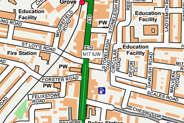
N17 9JW is located in the Tottenham Hale electoral ward, within the London borough of Haringey and the English Parliamentary constituency of Tottenham. The Sub Integrated Care Board (ICB) Location is NHS North Central London ICB - 93C and the police force is Metropolitan Police. This postcode has been in use since July 1983.


GetTheData
Source: OS OpenMap – Local (Ordnance Survey)
Source: OS VectorMap District (Ordnance Survey)
Licence: Open Government Licence (requires attribution)
| Easting | 533823 |
| Northing | 189924 |
| Latitude | 51.592279 |
| Longitude | -0.069534 |
GetTheData
Source: Open Postcode Geo
Licence: Open Government Licence
| Country | England |
| Postcode District | N17 |
| ➜ N17 open data dashboard ➜ See where N17 is on a map | |
GetTheData
Source: Land Registry Price Paid Data
Licence: Open Government Licence
Elevation or altitude of N17 9JW as distance above sea level:
| Metres | Feet | |
|---|---|---|
| Elevation | 10m | 33ft |
Elevation is measured from the approximate centre of the postcode, to the nearest point on an OS contour line from OS Terrain 50, which has contour spacing of ten vertical metres.
➜ How high above sea level am I? Find the elevation of your current position using your device's GPS.
GetTheData
Source: Open Postcode Elevation
Licence: Open Government Licence
| Ward | Tottenham Hale |
| Constituency | Tottenham |
GetTheData
Source: ONS Postcode Database
Licence: Open Government Licence
| January 2024 | Criminal damage and arson | On or near Supermarket | 153m |
| January 2024 | Drugs | On or near Supermarket | 153m |
| January 2024 | Drugs | On or near Supermarket | 153m |
| ➜ Get more crime data in our Crime section | |||
GetTheData
Source: data.police.uk
Licence: Open Government Licence
| St Loys Road | Bruce Grove | 38m |
| Tottenham Police Station | Bruce Grove | 52m |
| Tottenham High Rd Bruce Grove | Bruce Grove | 87m |
| Bruce Grove Station | Bruce Grove | 97m |
| Tottenham Police Station (High Road) | Bruce Grove | 116m |
| Tottenham Hale Underground Station | Tottenham Hale | 794m |
| Seven Sisters Underground Station | Seven Sisters | 1,018m |
| Bruce Grove Station | 0.2km |
| Tottenham Hale Station | 0.8km |
| Seven Sisters Station | 1.2km |
GetTheData
Source: NaPTAN
Licence: Open Government Licence
| Percentage of properties with Next Generation Access | 100.0% |
| Percentage of properties with Superfast Broadband | 100.0% |
| Percentage of properties with Ultrafast Broadband | 0.0% |
| Percentage of properties with Full Fibre Broadband | 0.0% |
Superfast Broadband is between 30Mbps and 300Mbps
Ultrafast Broadband is > 300Mbps
| Percentage of properties unable to receive 2Mbps | 0.0% |
| Percentage of properties unable to receive 5Mbps | 0.0% |
| Percentage of properties unable to receive 10Mbps | 0.0% |
| Percentage of properties unable to receive 30Mbps | 0.0% |
GetTheData
Source: Ofcom
Licence: Ofcom Terms of Use (requires attribution)
GetTheData
Source: ONS Postcode Database
Licence: Open Government Licence


➜ Get more ratings from the Food Standards Agency
GetTheData
Source: Food Standards Agency
Licence: FSA terms & conditions
| Last Collection | |||
|---|---|---|---|
| Location | Mon-Fri | Sat | Distance |
| Stoneleigh Road/High Road | 17:30 | 12:00 | 21m |
| Tottenham Delivery Office | 18:45 | 12:00 | 187m |
| Bruce Grove | 17:30 | 12:00 | 193m |
GetTheData
Source: Dracos
Licence: Creative Commons Attribution-ShareAlike
| Facility | Distance |
|---|---|
| The John Loughborough School (Closed) Holcombe Road, Tottenham, London Sports Hall | 197m |
| Welbourne Centre (Closed) Chesnut Road, London Sports Hall | 390m |
| The Gym Group (London Tottenham High Road) High Road, Tottenham, London Health and Fitness Gym | 417m |
GetTheData
Source: Active Places
Licence: Open Government Licence
| School | Phase of Education | Distance |
|---|---|---|
| Hyland House School Holcombe Road, Tottenham, London, London, N17 9AB | Not applicable | 147m |
| Bruce Grove Primary School Sperling Road, Tottenham, London, N17 6UH | Primary | 225m |
| Holy Trinity CofE Primary School Somerset Road, Tottenham, London, N17 9EJ | Primary | 290m |
GetTheData
Source: Edubase
Licence: Open Government Licence
The below table lists the International Territorial Level (ITL) codes (formerly Nomenclature of Territorial Units for Statistics (NUTS) codes) and Local Administrative Units (LAU) codes for N17 9JW:
| ITL 1 Code | Name |
|---|---|
| TLI | London |
| ITL 2 Code | Name |
| TLI4 | Inner London - East |
| ITL 3 Code | Name |
| TLI43 | Haringey and Islington |
| LAU 1 Code | Name |
| E09000014 | Haringey |
GetTheData
Source: ONS Postcode Directory
Licence: Open Government Licence
The below table lists the Census Output Area (OA), Lower Layer Super Output Area (LSOA), and Middle Layer Super Output Area (MSOA) for N17 9JW:
| Code | Name | |
|---|---|---|
| OA | E00010455 | |
| LSOA | E01002081 | Haringey 012D |
| MSOA | E02000408 | Haringey 012 |
GetTheData
Source: ONS Postcode Directory
Licence: Open Government Licence
| N17 9JD | High Road | 39m |
| N17 9HS | Circular Road | 54m |
| N17 9JB | High Road | 72m |
| N17 6QA | High Road | 78m |
| N17 6UB | St Loys Road | 80m |
| N17 6UA | St Loys Road | 80m |
| N17 6QL | High Road | 89m |
| N17 6QH | High Road | 103m |
| N17 9AB | Holcombe Road | 120m |
| N17 9ES | Chesnut Road | 121m |
GetTheData
Source: Open Postcode Geo; Land Registry Price Paid Data
Licence: Open Government Licence