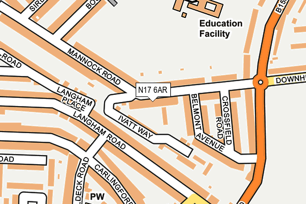
N17 6AR is located in the West Green electoral ward, within the London borough of Haringey and the English Parliamentary constituency of Tottenham. The Sub Integrated Care Board (ICB) Location is NHS North Central London ICB - 93C and the police force is Metropolitan Police. This postcode has been in use since January 1980.


GetTheData
Source: OS OpenMap – Local (Ordnance Survey)
Source: OS VectorMap District (Ordnance Survey)
Licence: Open Government Licence (requires attribution)
| Easting | 532011 |
| Northing | 189667 |
| Latitude | 51.590399 |
| Longitude | -0.095747 |
GetTheData
Source: Open Postcode Geo
Licence: Open Government Licence
| Country | England |
| Postcode District | N17 |
| ➜ N17 open data dashboard ➜ See where N17 is on a map | |
GetTheData
Source: Land Registry Price Paid Data
Licence: Open Government Licence
Elevation or altitude of N17 6AR as distance above sea level:
| Metres | Feet | |
|---|---|---|
| Elevation | 20m | 66ft |
Elevation is measured from the approximate centre of the postcode, to the nearest point on an OS contour line from OS Terrain 50, which has contour spacing of ten vertical metres.
➜ How high above sea level am I? Find the elevation of your current position using your device's GPS.
GetTheData
Source: Open Postcode Elevation
Licence: Open Government Licence
| Ward | West Green |
| Constituency | Tottenham |
GetTheData
Source: ONS Postcode Database
Licence: Open Government Licence
| January 2024 | Burglary | On or near Langham Road | 114m |
| January 2024 | Criminal damage and arson | On or near Langham Road | 114m |
| January 2024 | Criminal damage and arson | On or near Langham Road | 114m |
| ➜ Get more crime data in our Crime section | |||
GetTheData
Source: data.police.uk
Licence: Open Government Licence
| Belmont Road Langham Road | West Green | 288m |
| Westbury Avenue Baptist Church | Noel Park | 381m |
| Stanley Road West Green Road | Turnpike Lane | 388m |
| Stanley Road West Green Road | Turnpike Lane | 392m |
| Willow Walk (West Green Road) | Turnpike Lane | 393m |
| Turnpike Lane Underground Station | Turnpike Lane | 498m |
| Wood Green Underground Station | Wood Green | 1,256m |
| Hornsey Station | 1.2km |
| Harringay Green Lanes Station | 1.5km |
| Harringay Station | 1.6km |
GetTheData
Source: NaPTAN
Licence: Open Government Licence
GetTheData
Source: ONS Postcode Database
Licence: Open Government Licence


➜ Get more ratings from the Food Standards Agency
GetTheData
Source: Food Standards Agency
Licence: FSA terms & conditions
| Last Collection | |||
|---|---|---|---|
| Location | Mon-Fri | Sat | Distance |
| 69 Crossfield Road | 17:30 | 12:00 | 148m |
| Langham Road/Belmont Road | 17:30 | 12:00 | 272m |
| Stanmore Road/Waldeck Road | 17:30 | 12:00 | 306m |
GetTheData
Source: Dracos
Licence: Creative Commons Attribution-ShareAlike
| Facility | Distance |
|---|---|
| Downhills Recreation Ground Downhills Park Road, London Grass Pitches, Outdoor Tennis Courts | 364m |
| Park View School West Green Road, London Sports Hall, Squash Courts, Studio, Artificial Grass Pitch | 507m |
| Russell Park Maurice Avenue, Wood Green, London Grass Pitches | 542m |
GetTheData
Source: Active Places
Licence: Open Government Licence
| School | Phase of Education | Distance |
|---|---|---|
| The Grove Downhills Park Road, Tottenham, London, N17 6AR | Not applicable | 10m |
| Belmont Junior School Rusper Road, London, N22 6RA | Primary | 220m |
| Belmont Infant School Rusper Road, Belmont Infant School Rusper Road, London, N22 6RA | Primary | 220m |
GetTheData
Source: Edubase
Licence: Open Government Licence
The below table lists the International Territorial Level (ITL) codes (formerly Nomenclature of Territorial Units for Statistics (NUTS) codes) and Local Administrative Units (LAU) codes for N17 6AR:
| ITL 1 Code | Name |
|---|---|
| TLI | London |
| ITL 2 Code | Name |
| TLI4 | Inner London - East |
| ITL 3 Code | Name |
| TLI43 | Haringey and Islington |
| LAU 1 Code | Name |
| E09000014 | Haringey |
GetTheData
Source: ONS Postcode Directory
Licence: Open Government Licence
The below table lists the Census Output Area (OA), Lower Layer Super Output Area (LSOA), and Middle Layer Super Output Area (MSOA) for N17 6AR:
| Code | Name | |
|---|---|---|
| OA | E00010487 | |
| LSOA | E01002084 | Haringey 019B |
| MSOA | E02000415 | Haringey 019 |
GetTheData
Source: ONS Postcode Directory
Licence: Open Government Licence
| N17 6AP | Downhills Park Road | 86m |
| N17 6PF | Ivatt Way | 98m |
| N15 3LX | Langham Road | 108m |
| N22 6AB | Mannock Road | 110m |
| N17 6AX | Belmont Avenue | 129m |
| N17 6AS | Downhills Park Road | 136m |
| N15 3LR | Langham Road | 149m |
| N15 3ES | Carlingford Road | 158m |
| N15 3NA | Langham Place | 161m |
| N17 6AY | Crossfield Road | 173m |
GetTheData
Source: Open Postcode Geo; Land Registry Price Paid Data
Licence: Open Government Licence