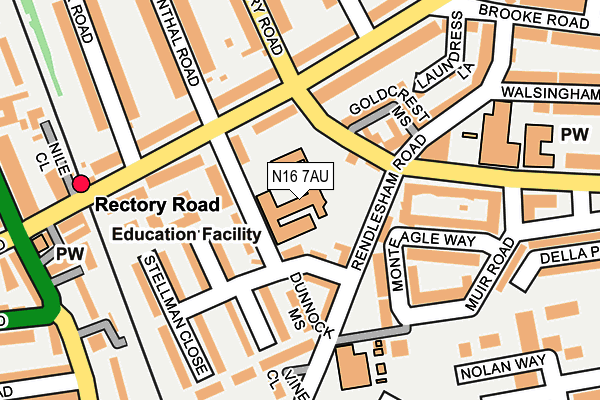
N16 7AU is located in the Hackney Downs electoral ward, within the London borough of Hackney and the English Parliamentary constituency of Hackney North and Stoke Newington. The Sub Integrated Care Board (ICB) Location is NHS North East London ICB - A3A8R and the police force is Metropolitan Police. This postcode has been in use since January 1980.


GetTheData
Source: OS OpenMap – Local (Ordnance Survey)
Source: OS VectorMap District (Ordnance Survey)
Licence: Open Government Licence (requires attribution)
| Easting | 534224 |
| Northing | 186153 |
| Latitude | 51.558297 |
| Longitude | -0.065188 |
GetTheData
Source: Open Postcode Geo
Licence: Open Government Licence
| Country | England |
| Postcode District | N16 |
| ➜ N16 open data dashboard ➜ See where N16 is on a map ➜ Where is London? | |
GetTheData
Source: Land Registry Price Paid Data
Licence: Open Government Licence
Elevation or altitude of N16 7AU as distance above sea level:
| Metres | Feet | |
|---|---|---|
| Elevation | 20m | 66ft |
Elevation is measured from the approximate centre of the postcode, to the nearest point on an OS contour line from OS Terrain 50, which has contour spacing of ten vertical metres.
➜ How high above sea level am I? Find the elevation of your current position using your device's GPS.
GetTheData
Source: Open Postcode Elevation
Licence: Open Government Licence
| Ward | Hackney Downs |
| Constituency | Hackney North And Stoke Newington |
GetTheData
Source: ONS Postcode Database
Licence: Open Government Licence
| June 2022 | Bicycle theft | On or near Rendlesham Road | 79m |
| June 2022 | Violence and sexual offences | On or near Rendlesham Road | 79m |
| June 2022 | Violence and sexual offences | On or near Rendlesham Road | 79m |
| ➜ Get more crime data in our Crime section | |||
GetTheData
Source: data.police.uk
Licence: Open Government Licence
| Ottaway Street | Shacklewell | 120m |
| Ottaway Street | Shacklewell | 172m |
| Muir Road | Lower Clapton | 186m |
| Muir Road | Lower Clapton | 231m |
| Rectory Road Downs Road (Rectory Road) | Shacklewell | 284m |
| Rectory Road Station | 0.2km |
| Clapton Station | 0.7km |
| Stoke Newington Station | 0.9km |
GetTheData
Source: NaPTAN
Licence: Open Government Licence
GetTheData
Source: ONS Postcode Database
Licence: Open Government Licence


➜ Get more ratings from the Food Standards Agency
GetTheData
Source: Food Standards Agency
Licence: FSA terms & conditions
| Last Collection | |||
|---|---|---|---|
| Location | Mon-Fri | Sat | Distance |
| 81 Evering Road | 17:30 | 12:00 | 253m |
| Evering Road/Brooke Road | 17:30 | 12:00 | 271m |
| Rectory Road/Foulden Road | 17:30 | 12:00 | 315m |
GetTheData
Source: Dracos
Licence: Creative Commons Attribution-ShareAlike
| Facility | Distance |
|---|---|
| Hackney Downs Downs Park Road, Hackney, London Grass Pitches, Outdoor Tennis Courts | 548m |
| Bsix Sixth Form College Kenninghall Road, London Health and Fitness Gym, Sports Hall | 594m |
| Sunstone Health & Leisure Club For Women (Closed) Northwold Road, Stoke Newington, London Swimming Pool, Health and Fitness Gym, Studio | 670m |
GetTheData
Source: Active Places
Licence: Open Government Licence
| School | Phase of Education | Distance |
|---|---|---|
| Benthal Primary School Benthal Road, Hackney, London, N16 7AU | Primary | 0m |
| The Boxing Academy AP Free School 1 Monteagle Way, Hackney, London, E5 8PH | Not applicable | 179m |
| St Scholastica's Catholic Primary School Kenninghall Road, Clapton, London, E5 8BS | Primary | 193m |
GetTheData
Source: Edubase
Licence: Open Government Licence
The below table lists the International Territorial Level (ITL) codes (formerly Nomenclature of Territorial Units for Statistics (NUTS) codes) and Local Administrative Units (LAU) codes for N16 7AU:
| ITL 1 Code | Name |
|---|---|
| TLI | London |
| ITL 2 Code | Name |
| TLI4 | Inner London - East |
| ITL 3 Code | Name |
| TLI41 | Hackney and Newham |
| LAU 1 Code | Name |
| E09000012 | Hackney |
GetTheData
Source: ONS Postcode Directory
Licence: Open Government Licence
The below table lists the Census Output Area (OA), Lower Layer Super Output Area (LSOA), and Middle Layer Super Output Area (MSOA) for N16 7AU:
| Code | Name | |
|---|---|---|
| OA | E00008824 | |
| LSOA | E01001764 | Hackney 010A |
| MSOA | E02000354 | Hackney 010 |
GetTheData
Source: ONS Postcode Directory
Licence: Open Government Licence
| E5 8PJ | Rendlesham Road | 63m |
| N16 7AT | Benthal Road | 68m |
| N16 7ST | Benthal Road | 84m |
| N16 7AX | Evering Road | 87m |
| E5 8QZ | Stellman Close | 125m |
| N16 7BU | Evering Road | 128m |
| E5 8PH | Monteagle Way | 133m |
| N16 7SW | Evering Road | 137m |
| E5 8QN | Stellman Close | 141m |
| E5 8JF | Monteagle Way | 146m |
GetTheData
Source: Open Postcode Geo; Land Registry Price Paid Data
Licence: Open Government Licence