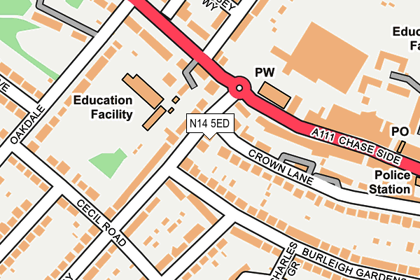
N14 5ED lies on Chase Way in London. N14 5ED is located in the Brunswick Park electoral ward, within the London borough of Barnet and the English Parliamentary constituency of Chipping Barnet. The Sub Integrated Care Board (ICB) Location is NHS North Central London ICB - 93C and the police force is Metropolitan Police. This postcode has been in use since January 1980.


GetTheData
Source: OS OpenMap – Local (Ordnance Survey)
Source: OS VectorMap District (Ordnance Survey)
Licence: Open Government Licence (requires attribution)
| Easting | 529258 |
| Northing | 194378 |
| Latitude | 51.633373 |
| Longitude | -0.133729 |
GetTheData
Source: Open Postcode Geo
Licence: Open Government Licence
| Street | Chase Way |
| Town/City | London |
| Country | England |
| Postcode District | N14 |
| ➜ N14 open data dashboard ➜ See where N14 is on a map ➜ Where is London? | |
GetTheData
Source: Land Registry Price Paid Data
Licence: Open Government Licence
Elevation or altitude of N14 5ED as distance above sea level:
| Metres | Feet | |
|---|---|---|
| Elevation | 80m | 262ft |
Elevation is measured from the approximate centre of the postcode, to the nearest point on an OS contour line from OS Terrain 50, which has contour spacing of ten vertical metres.
➜ How high above sea level am I? Find the elevation of your current position using your device's GPS.
GetTheData
Source: Open Postcode Elevation
Licence: Open Government Licence
| Ward | Brunswick Park |
| Constituency | Chipping Barnet |
GetTheData
Source: ONS Postcode Database
Licence: Open Government Licence
| January 2024 | Vehicle crime | On or near Petrol Station | 39m |
| January 2024 | Vehicle crime | On or near Ramsey Way | 202m |
| January 2024 | Drugs | On or near Ramsey Way | 202m |
| ➜ Get more crime data in our Crime section | |||
GetTheData
Source: data.police.uk
Licence: Open Government Licence
| Southgate Asda (Chase Side) | Southgate | 81m |
| Southgate Police Station | Southgate | 159m |
| Southgate Asda (Chase Side) | Southgate | 188m |
| Southgate Police Station (Chase Side) | Southgate | 226m |
| Avenue Road (N14) | Southgate | 400m |
| Southgate Underground Station | Southgate | 428m |
| New Southgate Station | 2.2km |
| Winchmore Hill Station | 2.3km |
| Oakleigh Park Station | 2.3km |
GetTheData
Source: NaPTAN
Licence: Open Government Licence
| Percentage of properties with Next Generation Access | 100.0% |
| Percentage of properties with Superfast Broadband | 100.0% |
| Percentage of properties with Ultrafast Broadband | 100.0% |
| Percentage of properties with Full Fibre Broadband | 100.0% |
Superfast Broadband is between 30Mbps and 300Mbps
Ultrafast Broadband is > 300Mbps
| Percentage of properties unable to receive 2Mbps | 0.0% |
| Percentage of properties unable to receive 5Mbps | 0.0% |
| Percentage of properties unable to receive 10Mbps | 0.0% |
| Percentage of properties unable to receive 30Mbps | 0.0% |
GetTheData
Source: Ofcom
Licence: Ofcom Terms of Use (requires attribution)
GetTheData
Source: ONS Postcode Database
Licence: Open Government Licence


➜ Get more ratings from the Food Standards Agency
GetTheData
Source: Food Standards Agency
Licence: FSA terms & conditions
| Last Collection | |||
|---|---|---|---|
| Location | Mon-Fri | Sat | Distance |
| Chase Way/Burleigh Gardens | 17:30 | 12:00 | 62m |
| 121 Chase Side | 17:30 | 12:00 | 119m |
| Oakdale/Manor Drive | 17:30 | 12:00 | 267m |
GetTheData
Source: Dracos
Licence: Creative Commons Attribution-ShareAlike
| Facility | Distance |
|---|---|
| Osidge Primary School Chase Side, London Grass Pitches | 126m |
| Bramley Bowls Centre Chase Side, London Indoor Bowls, Squash Courts | 296m |
| Ashmole Academy Cecil Road, London Sports Hall, Artificial Grass Pitch, Grass Pitches | 380m |
GetTheData
Source: Active Places
Licence: Open Government Licence
| School | Phase of Education | Distance |
|---|---|---|
| Osidge Primary School Chase Side, Southgate, London, N14 5HD | Primary | 117m |
| Ashmole Academy Cecil Road, Southgate, London, N14 5RJ | Secondary | 363m |
| St Andrew's Southgate Primary School (CE) 297 Chase Road, Southgate, London, N14 6JA | Primary | 417m |
GetTheData
Source: Edubase
Licence: Open Government Licence
The below table lists the International Territorial Level (ITL) codes (formerly Nomenclature of Territorial Units for Statistics (NUTS) codes) and Local Administrative Units (LAU) codes for N14 5ED:
| ITL 1 Code | Name |
|---|---|
| TLI | London |
| ITL 2 Code | Name |
| TLI7 | Outer London - West and North West |
| ITL 3 Code | Name |
| TLI71 | Barnet |
| LAU 1 Code | Name |
| E09000003 | Barnet |
GetTheData
Source: ONS Postcode Directory
Licence: Open Government Licence
The below table lists the Census Output Area (OA), Lower Layer Super Output Area (LSOA), and Middle Layer Super Output Area (MSOA) for N14 5ED:
| Code | Name | |
|---|---|---|
| OA | E00000578 | |
| LSOA | E01000119 | Barnet 009C |
| MSOA | E02000032 | Barnet 009 |
GetTheData
Source: ONS Postcode Directory
Licence: Open Government Licence
| N14 5AH | Burleigh Gardens | 67m |
| N14 5DE | Chase Way | 76m |
| N14 5HY | Waggon Mews | 77m |
| N14 5SH | Crown Lane | 77m |
| N14 5HB | Crown Lane | 89m |
| N14 5AP | Burleigh Gardens | 94m |
| N14 5ES | Crown Lane | 102m |
| N14 5PP | Chase Side | 110m |
| N14 5HD | Chase Side | 114m |
| N14 5EB | Chase Way | 144m |
GetTheData
Source: Open Postcode Geo; Land Registry Price Paid Data
Licence: Open Government Licence