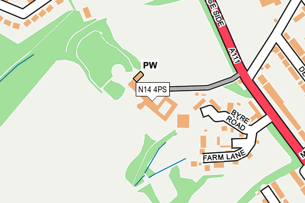
N14 4PS is located in the East Barnet electoral ward, within the London borough of Barnet and the English Parliamentary constituency of Chipping Barnet. The Sub Integrated Care Board (ICB) Location is NHS North Central London ICB - 93C and the police force is Metropolitan Police. This postcode has been in use since September 2005.


GetTheData
Source: OS OpenMap – Local (Ordnance Survey)
Source: OS VectorMap District (Ordnance Survey)
Licence: Open Government Licence (requires attribution)
| Easting | 528354 |
| Northing | 195158 |
| Latitude | 51.640589 |
| Longitude | -0.146497 |
GetTheData
Source: Open Postcode Geo
Licence: Open Government Licence
| Country | England |
| Postcode District | N14 |
| ➜ N14 open data dashboard ➜ See where N14 is on a map ➜ Where is London? | |
GetTheData
Source: Land Registry Price Paid Data
Licence: Open Government Licence
Elevation or altitude of N14 4PS as distance above sea level:
| Metres | Feet | |
|---|---|---|
| Elevation | 80m | 262ft |
Elevation is measured from the approximate centre of the postcode, to the nearest point on an OS contour line from OS Terrain 50, which has contour spacing of ten vertical metres.
➜ How high above sea level am I? Find the elevation of your current position using your device's GPS.
GetTheData
Source: Open Postcode Elevation
Licence: Open Government Licence
| Ward | East Barnet |
| Constituency | Chipping Barnet |
GetTheData
Source: ONS Postcode Database
Licence: Open Government Licence
| January 2024 | Violence and sexual offences | On or near Vernon Crescent | 295m |
| January 2024 | Burglary | On or near Cedar Rise | 339m |
| December 2023 | Burglary | On or near Vernon Crescent | 295m |
| ➜ Get more crime data in our Crime section | |||
GetTheData
Source: data.police.uk
Licence: Open Government Licence
| Cat Hill Campus | Oakwood | 184m |
| Cat Hill Campus | Oakwood | 219m |
| Monkfrith Way | Oakwood | 392m |
| Bramley Road (N14) | Oakwood | 424m |
| Bramley Road (N14) | Oakwood | 440m |
| Cockfosters Underground Station | Cockfosters | 1,230m |
| Oakwood Underground Station | Oakwood | 1,272m |
| Southgate Underground Station | Southgate | 1,589m |
| Oakleigh Park Station | 1.4km |
| New Barnet Station | 2km |
| New Southgate Station | 3km |
GetTheData
Source: NaPTAN
Licence: Open Government Licence
GetTheData
Source: ONS Postcode Database
Licence: Open Government Licence


➜ Get more ratings from the Food Standards Agency
GetTheData
Source: Food Standards Agency
Licence: FSA terms & conditions
| Last Collection | |||
|---|---|---|---|
| Location | Mon-Fri | Sat | Distance |
| Chase Side/Green Road | 17:30 | 12:00 | 230m |
| Oak Way/Monkfrith Way | 17:30 | 12:00 | 445m |
| 77 Trent Gardens | 17:30 | 12:00 | 562m |
GetTheData
Source: Dracos
Licence: Creative Commons Attribution-ShareAlike
| Facility | Distance |
|---|---|
| Oaktree School Chase Side, Southgate Grass Pitches, Artificial Grass Pitch | 275m |
| Bramley Sports Ground Green Road, London Grass Pitches | 350m |
| Oakhill Park Golf Course (Closed) Parkside Gardens, East Barnet, Barnet Golf | 475m |
GetTheData
Source: Active Places
Licence: Open Government Licence
| School | Phase of Education | Distance |
|---|---|---|
| Oaktree School Chase Side, Southgate, London, N14 4HN | Not applicable | 281m |
| Monkfrith Primary School Knoll Drive, London, N14 5NG | Primary | 427m |
| De Bohun Primary School Green Road, Southgate, London, N14 4AD | Primary | 528m |
GetTheData
Source: Edubase
Licence: Open Government Licence
The below table lists the International Territorial Level (ITL) codes (formerly Nomenclature of Territorial Units for Statistics (NUTS) codes) and Local Administrative Units (LAU) codes for N14 4PS:
| ITL 1 Code | Name |
|---|---|
| TLI | London |
| ITL 2 Code | Name |
| TLI7 | Outer London - West and North West |
| ITL 3 Code | Name |
| TLI71 | Barnet |
| LAU 1 Code | Name |
| E09000003 | Barnet |
GetTheData
Source: ONS Postcode Directory
Licence: Open Government Licence
The below table lists the Census Output Area (OA), Lower Layer Super Output Area (LSOA), and Middle Layer Super Output Area (MSOA) for N14 4PS:
| Code | Name | |
|---|---|---|
| OA | E00000857 | |
| LSOA | E01000172 | Barnet 003D |
| MSOA | E02000026 | Barnet 003 |
GetTheData
Source: ONS Postcode Directory
Licence: Open Government Licence
| N14 4PR | Chase Side | 270m |
| EN4 8QQ | Vernon Crescent | 274m |
| N14 4PX | De Bohun Avenue | 301m |
| N14 5NJ | Cedar Rise | 324m |
| N14 4AA | Green Road | 332m |
| EN4 8QG | Vernon Crescent | 338m |
| N14 5LH | Friars Walk | 343m |
| N14 4PU | De Bohun Avenue | 352m |
| N14 5NH | Cedar Rise | 354m |
| N14 5LJ | Friars Walk | 366m |
GetTheData
Source: Open Postcode Geo; Land Registry Price Paid Data
Licence: Open Government Licence