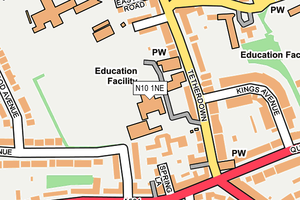
N10 1NE is located in the Fortis Green electoral ward, within the London borough of Haringey and the English Parliamentary constituency of Hornsey and Wood Green. The Sub Integrated Care Board (ICB) Location is NHS North Central London ICB - 93C and the police force is Metropolitan Police. This postcode has been in use since January 1980.


GetTheData
Source: OS OpenMap – Local (Ordnance Survey)
Source: OS VectorMap District (Ordnance Survey)
Licence: Open Government Licence (requires attribution)
| Easting | 528184 |
| Northing | 189834 |
| Latitude | 51.592781 |
| Longitude | -0.150924 |
GetTheData
Source: Open Postcode Geo
Licence: Open Government Licence
| Country | England |
| Postcode District | N10 |
| ➜ N10 open data dashboard ➜ See where N10 is on a map ➜ Where is London? | |
GetTheData
Source: Land Registry Price Paid Data
Licence: Open Government Licence
Elevation or altitude of N10 1NE as distance above sea level:
| Metres | Feet | |
|---|---|---|
| Elevation | 100m | 328ft |
Elevation is measured from the approximate centre of the postcode, to the nearest point on an OS contour line from OS Terrain 50, which has contour spacing of ten vertical metres.
➜ How high above sea level am I? Find the elevation of your current position using your device's GPS.
GetTheData
Source: Open Postcode Elevation
Licence: Open Government Licence
| Ward | Fortis Green |
| Constituency | Hornsey And Wood Green |
GetTheData
Source: ONS Postcode Database
Licence: Open Government Licence
| December 2023 | Other theft | On or near Midhurst Avenue | 358m |
| November 2023 | Burglary | On or near Page'S Lane | 296m |
| November 2023 | Burglary | On or near Midhurst Avenue | 358m |
| ➜ Get more crime data in our Crime section | |||
GetTheData
Source: data.police.uk
Licence: Open Government Licence
| Fortismere Avenue | Fortis Green | 194m |
| Midhurst Avenue | Fortis Green | 241m |
| Birchwood Avenue (N10) | Muswell Hill | 268m |
| Midhurst Avenue | Fortis Green | 278m |
| Creighton Avenue Muswell Hill | Muswell Hill | 344m |
| East Finchley Underground Station | East Finchley | 1,161m |
| Alexandra Palace Station | 2.2km |
| New Southgate Station | 2.4km |
| Bowes Park Station | 2.6km |
GetTheData
Source: NaPTAN
Licence: Open Government Licence
GetTheData
Source: ONS Postcode Database
Licence: Open Government Licence


➜ Get more ratings from the Food Standards Agency
GetTheData
Source: Food Standards Agency
Licence: FSA terms & conditions
| Last Collection | |||
|---|---|---|---|
| Location | Mon-Fri | Sat | Distance |
| Fortis Green | 17:30 | 12:00 | 283m |
| 174 Fortis Green Road | 17:30 | 12:00 | 289m |
| Twyford Avenue | 17:30 | 12:00 | 417m |
GetTheData
Source: Dracos
Licence: Creative Commons Attribution-ShareAlike
| Facility | Distance |
|---|---|
| Fortismere School Tetherdown, London Sports Hall, Health and Fitness Gym, Grass Pitches, Swimming Pool, Artificial Grass Pitch, Studio, Outdoor Tennis Courts | 0m |
| Manor Health & Leisure Club (Muswell Hill) Fortis Green, London Health and Fitness Gym, Swimming Pool, Studio | 205m |
| United Reform Church (Closed) Tetherdown, London Sports Hall | 209m |
GetTheData
Source: Active Places
Licence: Open Government Licence
| School | Phase of Education | Distance |
|---|---|---|
| Fortismere School Southwing, Tetherdown, Muswell Hill, London, N10 1NE | Secondary | 9m |
| Our Lady of Muswell Catholic Primary School Pages Lane, Muswell Hill, London, N10 1PS | Primary | 222m |
| Blanche Nevile School Burlington Road, Muswell Hill, London, N10 1NJ | Not applicable | 230m |
GetTheData
Source: Edubase
Licence: Open Government Licence
The below table lists the International Territorial Level (ITL) codes (formerly Nomenclature of Territorial Units for Statistics (NUTS) codes) and Local Administrative Units (LAU) codes for N10 1NE:
| ITL 1 Code | Name |
|---|---|
| TLI | London |
| ITL 2 Code | Name |
| TLI4 | Inner London - East |
| ITL 3 Code | Name |
| TLI43 | Haringey and Islington |
| LAU 1 Code | Name |
| E09000014 | Haringey |
GetTheData
Source: ONS Postcode Directory
Licence: Open Government Licence
The below table lists the Census Output Area (OA), Lower Layer Super Output Area (LSOA), and Middle Layer Super Output Area (MSOA) for N10 1NE:
| Code | Name | |
|---|---|---|
| OA | E00010002 | |
| LSOA | E01001996 | Haringey 014C |
| MSOA | E02000410 | Haringey 014 |
GetTheData
Source: ONS Postcode Directory
Licence: Open Government Licence
| N10 1ND | Tetherdown | 91m |
| N2 9NP | Twyford Avenue | 120m |
| N10 3PB | Fortis Green | 125m |
| N10 1NG | Tetherdown | 134m |
| N10 1NB | Tetherdown | 151m |
| N2 9NN | Twyford Avenue | 153m |
| N10 1NH | Tetherdown | 153m |
| N10 1NJ | Burlington Road | 160m |
| N10 3ES | Fortis Green | 181m |
| N10 3ET | Fortis Green | 181m |
GetTheData
Source: Open Postcode Geo; Land Registry Price Paid Data
Licence: Open Government Licence