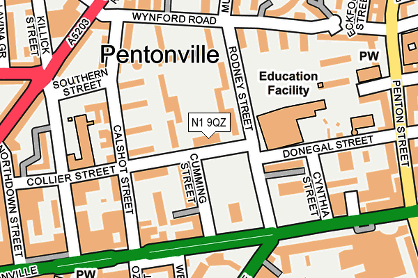
N1 9QZ is located in the Caledonian electoral ward, within the London borough of Islington and the English Parliamentary constituency of Islington South and Finsbury. The Sub Integrated Care Board (ICB) Location is NHS North Central London ICB - 93C and the police force is Metropolitan Police. This postcode has been in use since January 2003.


GetTheData
Source: OS OpenMap – Local (Ordnance Survey)
Source: OS VectorMap District (Ordnance Survey)
Licence: Open Government Licence (requires attribution)
| Easting | 530818 |
| Northing | 183207 |
| Latitude | 51.532622 |
| Longitude | -0.115386 |
GetTheData
Source: Open Postcode Geo
Licence: Open Government Licence
| Country | England |
| Postcode District | N1 |
| ➜ N1 open data dashboard ➜ See where N1 is on a map ➜ Where is London? | |
GetTheData
Source: Land Registry Price Paid Data
Licence: Open Government Licence
Elevation or altitude of N1 9QZ as distance above sea level:
| Metres | Feet | |
|---|---|---|
| Elevation | 30m | 98ft |
Elevation is measured from the approximate centre of the postcode, to the nearest point on an OS contour line from OS Terrain 50, which has contour spacing of ten vertical metres.
➜ How high above sea level am I? Find the elevation of your current position using your device's GPS.
GetTheData
Source: Open Postcode Elevation
Licence: Open Government Licence
| Ward | Caledonian |
| Constituency | Islington South And Finsbury |
GetTheData
Source: ONS Postcode Database
Licence: Open Government Licence
| January 2024 | Public order | On or near Lorenzo Street | 239m |
| January 2024 | Violence and sexual offences | On or near Maygood Street | 311m |
| January 2024 | Anti-social behaviour | On or near Theatre/Concert Hall | 341m |
| ➜ Get more crime data in our Crime section | |||
GetTheData
Source: data.police.uk
Licence: Open Government Licence
| Penton Rise (Pentonville Road) | Pentonville | 149m |
| Penton Rise (Pentonville Road) | Pentonville | 157m |
| Penton Rise | Pentonville | 225m |
| Killick Street (Caledonian Road) | Pentonville | 240m |
| Killick Street (Caledonian Road) | Pentonville | 250m |
| King's Cross St. Pancras Underground Station | King's Cross | 584m |
| Angel Underground Station | Angel | 658m |
| Russell Square Underground Station | Russell Square | 1,229m |
| Euston Underground Station | Euston | 1,376m |
| Farringdon Underground Station | Farringdon | 1,556m |
| London Kings Cross Station | 0.6km |
| London St Pancras International Station | 0.8km |
| London St Pancras International LL Station | 0.8km |
GetTheData
Source: NaPTAN
Licence: Open Government Licence
GetTheData
Source: ONS Postcode Database
Licence: Open Government Licence


➜ Get more ratings from the Food Standards Agency
GetTheData
Source: Food Standards Agency
Licence: FSA terms & conditions
| Last Collection | |||
|---|---|---|---|
| Location | Mon-Fri | Sat | Distance |
| 192 Pentonville Road | 18:30 | 12:00 | 218m |
| 100 Caledonian Road | 18:30 | 12:00 | 239m |
| Kings Cross Road (Britannia St) | 18:30 | 12:00 | 286m |
GetTheData
Source: Dracos
Licence: Creative Commons Attribution-ShareAlike
| Facility | Distance |
|---|---|
| Elizabeth Garrett Anderson School Donegal Street, London Health and Fitness Gym, Sports Hall, Studio, Outdoor Tennis Courts | 128m |
| Winton Primary School Killick Street, London Sports Hall | 184m |
| Anytime Fitness (London Kings Cross) Pentonville Road, London Health and Fitness Gym | 222m |
GetTheData
Source: Active Places
Licence: Open Government Licence
| School | Phase of Education | Distance |
|---|---|---|
| The Pears Family School 4-8 Rodney Street, London, N1 9JH | Not applicable | 130m |
| The Gower School 10 Cynthia Street, Barnsbury, London, N1 9JF | Not applicable | 144m |
| Winton Primary School Killick Street, Pentonville Road, London, N1 9AZ | Primary | 187m |
GetTheData
Source: Edubase
Licence: Open Government Licence
The below table lists the International Territorial Level (ITL) codes (formerly Nomenclature of Territorial Units for Statistics (NUTS) codes) and Local Administrative Units (LAU) codes for N1 9QZ:
| ITL 1 Code | Name |
|---|---|
| TLI | London |
| ITL 2 Code | Name |
| TLI4 | Inner London - East |
| ITL 3 Code | Name |
| TLI43 | Haringey and Islington |
| LAU 1 Code | Name |
| E09000019 | Islington |
GetTheData
Source: ONS Postcode Directory
Licence: Open Government Licence
The below table lists the Census Output Area (OA), Lower Layer Super Output Area (LSOA), and Middle Layer Super Output Area (MSOA) for N1 9QZ:
| Code | Name | |
|---|---|---|
| OA | E00013392 | |
| LSOA | E01002697 | Islington 019B |
| MSOA | E02000572 | Islington 019 |
GetTheData
Source: ONS Postcode Directory
Licence: Open Government Licence
| N1 9QQ | Priory Green | 42m |
| N1 9DD | Collier Street | 57m |
| N1 9QH | Priory Green | 58m |
| N1 9DE | Priory Green | 64m |
| N1 9JA | Cumming Street | 69m |
| N1 9DJ | Calshot Street | 93m |
| N1 9QJ | Priory Green | 93m |
| N1 9JH | Rodney Street | 93m |
| N1 9DH | Priory Green Estate | 99m |
| N1 9JU | Collier Street | 99m |
GetTheData
Source: Open Postcode Geo; Land Registry Price Paid Data
Licence: Open Government Licence