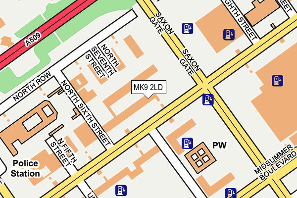
MK9 2LD is located in the Central Milton Keynes electoral ward, within the unitary authority of Milton Keynes and the English Parliamentary constituency of Milton Keynes North. The Sub Integrated Care Board (ICB) Location is NHS Bedfordshire, Luton and Milton Keynes ICB - M1J4Y and the police force is Thames Valley. This postcode has been in use since June 1981.


GetTheData
Source: OS OpenMap – Local (Ordnance Survey)
Source: OS VectorMap District (Ordnance Survey)
Licence: Open Government Licence (requires attribution)
| Easting | 484943 |
| Northing | 238908 |
| Latitude | 52.042073 |
| Longitude | -0.762939 |
GetTheData
Source: Open Postcode Geo
Licence: Open Government Licence
| Country | England |
| Postcode District | MK9 |
| ➜ MK9 open data dashboard ➜ See where MK9 is on a map | |
GetTheData
Source: Land Registry Price Paid Data
Licence: Open Government Licence
Elevation or altitude of MK9 2LD as distance above sea level:
| Metres | Feet | |
|---|---|---|
| Elevation | 110m | 361ft |
Elevation is measured from the approximate centre of the postcode, to the nearest point on an OS contour line from OS Terrain 50, which has contour spacing of ten vertical metres.
➜ How high above sea level am I? Find the elevation of your current position using your device's GPS.
GetTheData
Source: Open Postcode Elevation
Licence: Open Government Licence
| Ward | Central Milton Keynes |
| Constituency | Milton Keynes North |
GetTheData
Source: ONS Postcode Database
Licence: Open Government Licence
| January 2024 | Shoplifting | On or near Shopping Area | 312m |
| January 2024 | Shoplifting | On or near Shopping Area | 312m |
| January 2024 | Shoplifting | On or near Shopping Area | 312m |
| ➜ Get more crime data in our Crime section | |||
GetTheData
Source: data.police.uk
Licence: Open Government Licence
| Central Business Exchange (Midsummer Boulevard) | Central Milton Keynes | 282m |
| Central Business Exchange (Midsummer Boulevard) | Central Milton Keynes | 292m |
| Central Business Exchange (Midsummer Boulevard) | Central Milton Keynes | 299m |
| Central Business Exchange (Midsummer Boulevard) | Central Milton Keynes | 306m |
| Midsummer Place (Midsummer Boulevard) | Central Milton Keynes | 310m |
| Milton Keynes Central Station | 1.2km |
| Wolverton Station | 3.9km |
| Fenny Stratford Station | 5.7km |
GetTheData
Source: NaPTAN
Licence: Open Government Licence
GetTheData
Source: ONS Postcode Database
Licence: Open Government Licence


➜ Get more ratings from the Food Standards Agency
GetTheData
Source: Food Standards Agency
Licence: FSA terms & conditions
| Last Collection | |||
|---|---|---|---|
| Location | Mon-Fri | Sat | Distance |
| Ashton House Silbury Boulevard | 18:30 | 12:00 | 62m |
| Ashton House East | 18:30 | 88m | |
| Marks & Spencer Square | 18:30 | 12:00 | 219m |
GetTheData
Source: Dracos
Licence: Creative Commons Attribution-ShareAlike
| Facility | Distance |
|---|---|
| Spirit Health Club (Milton Keynes) Saxon Gate West, Milton Keynes Swimming Pool, Health and Fitness Gym | 387m |
| Bannatyne Health Club (Milton Keynes) Midsummer Boulevard, Milton Keynes Swimming Pool, Health and Fitness Gym, Studio | 389m |
| Conniburrow Community Sports Pavilion Conniburrow Boulevard, Conniburrow, Milton Keynes Grass Pitches, Outdoor Tennis Courts | 646m |
GetTheData
Source: Active Places
Licence: Open Government Licence
| School | Phase of Education | Distance |
|---|---|---|
| Germander Park School 1 Germander Place, Conniburrow, Milton Keynes, MK14 7DU | Primary | 739m |
| Summerfield School Downley Avenue, Bradwell Common, Milton Keynes, MK13 8PG | Primary | 747m |
| Jubilee Wood Primary School 1 Fishermead Boulevard, Fishermead, Milton Keynes, MK6 2LB | Primary | 1.2km |
GetTheData
Source: Edubase
Licence: Open Government Licence
The below table lists the International Territorial Level (ITL) codes (formerly Nomenclature of Territorial Units for Statistics (NUTS) codes) and Local Administrative Units (LAU) codes for MK9 2LD:
| ITL 1 Code | Name |
|---|---|
| TLJ | South East (England) |
| ITL 2 Code | Name |
| TLJ1 | Berkshire, Buckinghamshire and Oxfordshire |
| ITL 3 Code | Name |
| TLJ12 | Milton Keynes |
| LAU 1 Code | Name |
| E06000042 | Milton Keynes |
GetTheData
Source: ONS Postcode Directory
Licence: Open Government Licence
The below table lists the Census Output Area (OA), Lower Layer Super Output Area (LSOA), and Middle Layer Super Output Area (MSOA) for MK9 2LD:
| Code | Name | |
|---|---|---|
| OA | E00084439 | |
| LSOA | E01033499 | Milton Keynes 014E |
| MSOA | E02003472 | Milton Keynes 014 |
GetTheData
Source: ONS Postcode Directory
Licence: Open Government Licence
| MK9 2AD | Silbury Boulevard | 232m |
| MK9 2AE | Silbury Boulevard | 257m |
| MK13 8AQ | Wisley Avenue | 295m |
| MK13 8AG | Wisley Avenue | 342m |
| MK9 2UB | Midsummer Boulevard | 345m |
| MK13 8BU | Wandsworth Place | 350m |
| MK13 8BX | Mitcham Place | 352m |
| MK9 3AW | North Ninth Street | 364m |
| MK9 3AN | North Ninth Street | 375m |
| MK13 8BL | Arbrook Avenue | 382m |
GetTheData
Source: Open Postcode Geo; Land Registry Price Paid Data
Licence: Open Government Licence