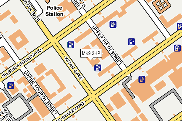
MK9 2HP is located in the Central Milton Keynes electoral ward, within the unitary authority of Milton Keynes and the English Parliamentary constituency of Milton Keynes North. The Sub Integrated Care Board (ICB) Location is NHS Bedfordshire, Luton and Milton Keynes ICB - M1J4Y and the police force is Thames Valley. This postcode has been in use since July 1986.


GetTheData
Source: OS OpenMap – Local (Ordnance Survey)
Source: OS VectorMap District (Ordnance Survey)
Licence: Open Government Licence (requires attribution)
| Easting | 484815 |
| Northing | 238604 |
| Latitude | 52.039370 |
| Longitude | -0.764860 |
GetTheData
Source: Open Postcode Geo
Licence: Open Government Licence
| Country | England |
| Postcode District | MK9 |
| ➜ MK9 open data dashboard ➜ See where MK9 is on a map ➜ Where is Milton Keynes? | |
GetTheData
Source: Land Registry Price Paid Data
Licence: Open Government Licence
Elevation or altitude of MK9 2HP as distance above sea level:
| Metres | Feet | |
|---|---|---|
| Elevation | 100m | 328ft |
Elevation is measured from the approximate centre of the postcode, to the nearest point on an OS contour line from OS Terrain 50, which has contour spacing of ten vertical metres.
➜ How high above sea level am I? Find the elevation of your current position using your device's GPS.
GetTheData
Source: Open Postcode Elevation
Licence: Open Government Licence
| Ward | Central Milton Keynes |
| Constituency | Milton Keynes North |
GetTheData
Source: ONS Postcode Database
Licence: Open Government Licence
| September 2023 | Shoplifting | On or near Parking Area | 419m |
| July 2023 | Burglary | On or near Parking Area | 419m |
| June 2022 | Bicycle theft | On or near Upper Fifth Street | 72m |
| ➜ Get more crime data in our Crime section | |||
GetTheData
Source: data.police.uk
Licence: Open Government Licence
| Central Business Exchange (Midsummer Boulevard) | Central Milton Keynes | 168m |
| Central Business Exchange (Midsummer Boulevard) | Central Milton Keynes | 184m |
| Central Business Exchange (Midsummer Boulevard) | Central Milton Keynes | 194m |
| Central Business Exchange (Midsummer Boulevard) | Central Milton Keynes | 211m |
| Santander House (Midsummer Boulevard) | Central Milton Keynes | 292m |
| Milton Keynes Central Station | 0.9km |
| Wolverton Station | 4km |
| Bletchley Station | 5.3km |
GetTheData
Source: NaPTAN
Licence: Open Government Licence
| Median download speed | 80.0Mbps |
| Average download speed | 79.2Mbps |
| Maximum download speed | 80.00Mbps |
| Median upload speed | 20.0Mbps |
| Average upload speed | 20.0Mbps |
| Maximum upload speed | 20.00Mbps |
GetTheData
Source: Ofcom
Licence: Ofcom Terms of Use (requires attribution)
Estimated total energy consumption in MK9 2HP by fuel type, 2015.
| Consumption (kWh) | 237,661 |
|---|---|
| Meter count | 8 |
| Mean (kWh/meter) | 29,708 |
| Median (kWh/meter) | 28,361 |
GetTheData
Source: Postcode level gas estimates: 2015 (experimental)
Source: Postcode level electricity estimates: 2015 (experimental)
Licence: Open Government Licence
GetTheData
Source: ONS Postcode Database
Licence: Open Government Licence


➜ Get more ratings from the Food Standards Agency
GetTheData
Source: Food Standards Agency
Licence: FSA terms & conditions
| Last Collection | |||
|---|---|---|---|
| Location | Mon-Fri | Sat | Distance |
| Acorn House | 18:30 | 137m | |
| Midsummer Boulevard | 18:30 | 12:00 | 221m |
| Grant Thornton House | 18:30 | 260m | |
GetTheData
Source: Dracos
Licence: Creative Commons Attribution-ShareAlike
| Facility | Distance |
|---|---|
| Bannatyne Health Club (Milton Keynes) Midsummer Boulevard, Milton Keynes Swimming Pool, Health and Fitness Gym, Studio | 308m |
| Spirit Health Club (Milton Keynes) Saxon Gate West, Milton Keynes Swimming Pool, Health and Fitness Gym | 373m |
| Snap Fitness (Milton Keynes) (Closed) South Row, Milton Keynes Health and Fitness Gym | 564m |
GetTheData
Source: Active Places
Licence: Open Government Licence
| School | Phase of Education | Distance |
|---|---|---|
| Summerfield School Downley Avenue, Bradwell Common, Milton Keynes, MK13 8PG | Primary | 833m |
| Germander Park School 1 Germander Place, Conniburrow, Milton Keynes, MK14 7DU | Primary | 1.1km |
| Oldbrook First School and Nursery Illingworth Place, Oldbrook, Milton Keynes, MK6 2NH | Primary | 1.1km |
GetTheData
Source: Edubase
Licence: Open Government Licence
The below table lists the International Territorial Level (ITL) codes (formerly Nomenclature of Territorial Units for Statistics (NUTS) codes) and Local Administrative Units (LAU) codes for MK9 2HP:
| ITL 1 Code | Name |
|---|---|
| TLJ | South East (England) |
| ITL 2 Code | Name |
| TLJ1 | Berkshire, Buckinghamshire and Oxfordshire |
| ITL 3 Code | Name |
| TLJ12 | Milton Keynes |
| LAU 1 Code | Name |
| E06000042 | Milton Keynes |
GetTheData
Source: ONS Postcode Directory
Licence: Open Government Licence
The below table lists the Census Output Area (OA), Lower Layer Super Output Area (LSOA), and Middle Layer Super Output Area (MSOA) for MK9 2HP:
| Code | Name | |
|---|---|---|
| OA | E00175396 | |
| LSOA | E01033500 | Milton Keynes 014F |
| MSOA | E02003472 | Milton Keynes 014 |
GetTheData
Source: ONS Postcode Directory
Licence: Open Government Licence
| MK9 2AE | Silbury Boulevard | 92m |
| MK9 2BQ | Witan Gate | 164m |
| MK9 2DA | Witan Gate | 210m |
| MK9 2DB | Witan Gate | 210m |
| MK9 2FB | Mortimer Square | 213m |
| MK9 2BX | Rillaton Walk | 251m |
| MK9 2UB | Midsummer Boulevard | 267m |
| MK9 2BS | Witan Gate | 273m |
| MK9 2BU | Witan Gate | 273m |
| MK9 2BN | Rillaton Walk | 294m |
GetTheData
Source: Open Postcode Geo; Land Registry Price Paid Data
Licence: Open Government Licence