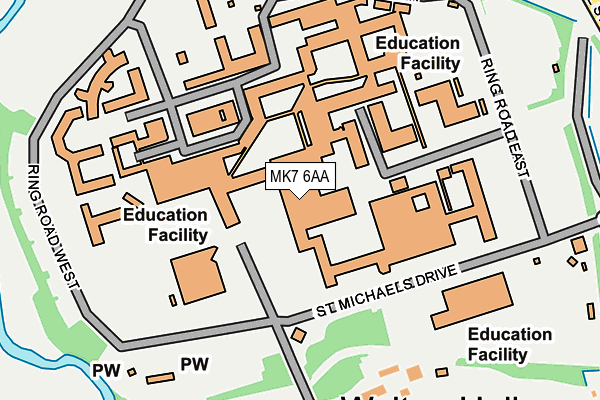
MK7 6AA is located in the Monkston electoral ward, within the unitary authority of Milton Keynes and the English Parliamentary constituency of Milton Keynes South. The Sub Integrated Care Board (ICB) Location is NHS Bedfordshire, Luton and Milton Keynes ICB - M1J4Y and the police force is Thames Valley. This postcode has been in use since January 1980.


GetTheData
Source: OS OpenMap – Local (Ordnance Survey)
Source: OS VectorMap District (Ordnance Survey)
Licence: Open Government Licence (requires attribution)
| Easting | 488625 |
| Northing | 237063 |
| Latitude | 52.024914 |
| Longitude | -0.709747 |
GetTheData
Source: Open Postcode Geo
Licence: Open Government Licence
| Country | England |
| Postcode District | MK7 |
| ➜ MK7 open data dashboard ➜ See where MK7 is on a map ➜ Where is Milton Keynes? | |
GetTheData
Source: Land Registry Price Paid Data
Licence: Open Government Licence
Elevation or altitude of MK7 6AA as distance above sea level:
| Metres | Feet | |
|---|---|---|
| Elevation | 70m | 230ft |
Elevation is measured from the approximate centre of the postcode, to the nearest point on an OS contour line from OS Terrain 50, which has contour spacing of ten vertical metres.
➜ How high above sea level am I? Find the elevation of your current position using your device's GPS.
GetTheData
Source: Open Postcode Elevation
Licence: Open Government Licence
| Ward | Monkston |
| Constituency | Milton Keynes South |
GetTheData
Source: ONS Postcode Database
Licence: Open Government Licence
| June 2022 | Violence and sexual offences | On or near Parking Area | 179m |
| April 2022 | Criminal damage and arson | On or near Parking Area | 179m |
| March 2022 | Other theft | On or near Parking Area | 179m |
| ➜ Get more crime data in our Crime section | |||
GetTheData
Source: data.police.uk
Licence: Open Government Licence
| The Open University (St. Michael's Drive) | Walton Hall | 104m |
| The Open University (St. Michael's Drive) | Walton Hall | 119m |
| Kents Hill Park (Brickhill Street V10) | Kents Hill | 344m |
| Kents Hill Park (Brickhill Street V10) | Kents Hill | 363m |
| Walton Drive (Groveway H9) | Walton Hall | 424m |
| Bow Brickhill Station | 2.5km |
| Fenny Stratford Station | 2.8km |
| Bletchley Station | 3.8km |
GetTheData
Source: NaPTAN
Licence: Open Government Licence
GetTheData
Source: ONS Postcode Database
Licence: Open Government Licence


➜ Get more ratings from the Food Standards Agency
GetTheData
Source: Food Standards Agency
Licence: FSA terms & conditions
| Last Collection | |||
|---|---|---|---|
| Location | Mon-Fri | Sat | Distance |
| Open University | 18:00 | 13:00 | 81m |
| De Montfort University | 18:00 | 12:00 | 499m |
| Castle Rose | 17:30 | 12:00 | 773m |
GetTheData
Source: Dracos
Licence: Creative Commons Attribution-ShareAlike
| Facility | Distance |
|---|---|
| Open University (Walton Hall Campus) Walton Drive, Walton Hall, Milton Keynes Grass Pitches, Squash Courts, Outdoor Tennis Courts | 73m |
| Livingwell Health Club (Milton Keynes) Timbold Drive, Kents Hill, Milton Keynes Health and Fitness Gym, Swimming Pool | 553m |
| Woughton On The Green Playing Fields Woughton On The Green, Milton Keynes Grass Pitches, Artificial Grass Pitch, Outdoor Tennis Courts | 672m |
GetTheData
Source: Active Places
Licence: Open Government Licence
| School | Phase of Education | Distance |
|---|---|---|
| The Open University Walton Hall, Milton Keynes, MK7 6AA | Not applicable | 0m |
| Kents Hill Park all-through school Kents Hill Park, Kents Hill, Milton Keynes, MK7 6BZ | All-through | 806m |
| Kents Hill School Birdlip Lane, Kents Hill, Milton Keynes, MK7 6HD | Primary | 866m |
GetTheData
Source: Edubase
Licence: Open Government Licence
The below table lists the International Territorial Level (ITL) codes (formerly Nomenclature of Territorial Units for Statistics (NUTS) codes) and Local Administrative Units (LAU) codes for MK7 6AA:
| ITL 1 Code | Name |
|---|---|
| TLJ | South East (England) |
| ITL 2 Code | Name |
| TLJ1 | Berkshire, Buckinghamshire and Oxfordshire |
| ITL 3 Code | Name |
| TLJ12 | Milton Keynes |
| LAU 1 Code | Name |
| E06000042 | Milton Keynes |
GetTheData
Source: ONS Postcode Directory
Licence: Open Government Licence
The below table lists the Census Output Area (OA), Lower Layer Super Output Area (LSOA), and Middle Layer Super Output Area (MSOA) for MK7 6AA:
| Code | Name | |
|---|---|---|
| OA | E00084890 | |
| LSOA | E01016820 | Milton Keynes 017C |
| MSOA | E02003475 | Milton Keynes 017 |
GetTheData
Source: ONS Postcode Directory
Licence: Open Government Licence
| MK7 6BB | Church Lane | 191m |
| MK7 6BA | 376m | |
| MK7 6HW | Southbridge Grove | 733m |
| MK7 7DL | Cloudberry | 742m |
| MK10 9PL | Ladbroke Grove | 757m |
| MK7 6HE | Crowborough Lane | 779m |
| MK6 3AP | Newport Road | 781m |
| MK7 7EG | Tatling Grove | 798m |
| MK7 6HA | Groombridge | 805m |
| MK6 3BQ | Castle Rose | 808m |
GetTheData
Source: Open Postcode Geo; Land Registry Price Paid Data
Licence: Open Government Licence