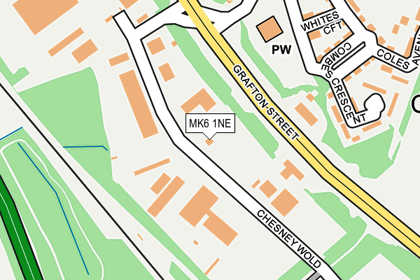
MK6 1NE lies on Chesney Wold in Bleak Hall, Milton Keynes. MK6 1NE is located in the Woughton & Fishermead electoral ward, within the unitary authority of Milton Keynes and the English Parliamentary constituency of Milton Keynes South. The Sub Integrated Care Board (ICB) Location is NHS Bedfordshire, Luton and Milton Keynes ICB - M1J4Y and the police force is Thames Valley. This postcode has been in use since August 1993.


GetTheData
Source: OS OpenMap – Local (Ordnance Survey)
Source: OS VectorMap District (Ordnance Survey)
Licence: Open Government Licence (requires attribution)
| Easting | 485518 |
| Northing | 236649 |
| Latitude | 52.021689 |
| Longitude | -0.755101 |
GetTheData
Source: Open Postcode Geo
Licence: Open Government Licence
| Street | Chesney Wold |
| Locality | Bleak Hall |
| Town/City | Milton Keynes |
| Country | England |
| Postcode District | MK6 |
| ➜ MK6 open data dashboard ➜ See where MK6 is on a map ➜ Where is Milton Keynes? | |
GetTheData
Source: Land Registry Price Paid Data
Licence: Open Government Licence
Elevation or altitude of MK6 1NE as distance above sea level:
| Metres | Feet | |
|---|---|---|
| Elevation | 90m | 295ft |
Elevation is measured from the approximate centre of the postcode, to the nearest point on an OS contour line from OS Terrain 50, which has contour spacing of ten vertical metres.
➜ How high above sea level am I? Find the elevation of your current position using your device's GPS.
GetTheData
Source: Open Postcode Elevation
Licence: Open Government Licence
| Ward | Woughton & Fishermead |
| Constituency | Milton Keynes South |
GetTheData
Source: ONS Postcode Database
Licence: Open Government Licence
| June 2022 | Public order | On or near Petrol Station | 150m |
| June 2022 | Other theft | On or near Marine Court | 229m |
| June 2022 | Other theft | On or near Parking Area | 477m |
| ➜ Chesney Wold crime map and outcomes | |||
GetTheData
Source: data.police.uk
Licence: Open Government Licence
| Bleak Hall Industrial Estate (Grafton Street V6) | Bleak Hall | 298m |
| Bleak Hall Industrial Estate (Grafton Street V6) | Bleak Hall | 310m |
| Leadenhall Roundabout South (Grafton Street V6) | Leadenhall | 348m |
| Leadenhall Roundabout South (Grafton Street V6) | Leadenhall | 368m |
| Phoenix Drive | Leadenhall | 498m |
| Milton Keynes Central Station | 1.9km |
| Bletchley Station | 3.2km |
| Fenny Stratford Station | 3.6km |
GetTheData
Source: NaPTAN
Licence: Open Government Licence
GetTheData
Source: ONS Postcode Database
Licence: Open Government Licence


➜ Get more ratings from the Food Standards Agency
GetTheData
Source: Food Standards Agency
Licence: FSA terms & conditions
| Last Collection | |||
|---|---|---|---|
| Location | Mon-Fri | Sat | Distance |
| Phoenix Drive | 18:00 | 12:00 | 480m |
| Chesneywold | 18:30 | 480m | |
| Post Office Garroways | 17:00 | 12:00 | 682m |
GetTheData
Source: Dracos
Licence: Creative Commons Attribution-ShareAlike
| Facility | Distance |
|---|---|
| St Pauls Catholic School Phoenix Drive, Leadenhall, Milton Keynes Grass Pitches, Sports Hall | 475m |
| Puregym (Milton Keynes Winterhill) Snowdon Drive, Milton Keynes Health and Fitness Gym, Studio | 538m |
| Jd Gyms (Milton Keynes) Snowdon Drive, Winterhill, Milton Keynes Health and Fitness Gym, Studio | 566m |
GetTheData
Source: Active Places
Licence: Open Government Licence
| School | Phase of Education | Distance |
|---|---|---|
| St Paul's Catholic School Phoenix Drive, Leadenhall, Milton Keynes, MK6 5EN | Secondary | 492m |
| Bridge Academy Jonathans, Coffee Hall, Milton Keynes, MK6 5DE | Not applicable | 674m |
| Milton Keynes College Chaffron Way Centre, Woughton Campus West, Leadenhall, Milton Keynes, MK6 5LP | 16 plus | 731m |
GetTheData
Source: Edubase
Licence: Open Government Licence
The below table lists the International Territorial Level (ITL) codes (formerly Nomenclature of Territorial Units for Statistics (NUTS) codes) and Local Administrative Units (LAU) codes for MK6 1NE:
| ITL 1 Code | Name |
|---|---|
| TLJ | South East (England) |
| ITL 2 Code | Name |
| TLJ1 | Berkshire, Buckinghamshire and Oxfordshire |
| ITL 3 Code | Name |
| TLJ12 | Milton Keynes |
| LAU 1 Code | Name |
| E06000042 | Milton Keynes |
GetTheData
Source: ONS Postcode Directory
Licence: Open Government Licence
The below table lists the Census Output Area (OA), Lower Layer Super Output Area (LSOA), and Middle Layer Super Output Area (MSOA) for MK6 1NE:
| Code | Name | |
|---|---|---|
| OA | E00084992 | |
| LSOA | E01016844 | Milton Keynes 023D |
| MSOA | E02003481 | Milton Keynes 023 |
GetTheData
Source: ONS Postcode Directory
Licence: Open Government Licence
| MK6 1LJ | Grafton Street | 115m |
| MK6 5LW | Marine Court | 227m |
| MK6 5LX | Combes Crescent | 232m |
| MK6 5LG | Whites Croft | 235m |
| MK6 5LF | Youngman Place | 249m |
| MK6 5LE | Coles Avenue | 282m |
| MK6 5ND | Phoenix Drive | 401m |
| MK6 5DL | Rochfords | 431m |
| MK6 5NF | Malbons Court | 444m |
| MK6 5LZ | Ludgate | 473m |
GetTheData
Source: Open Postcode Geo; Land Registry Price Paid Data
Licence: Open Government Licence