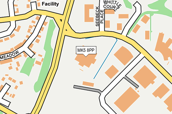
MK5 8PP lies on Davy Avenue in Knowlhill, Milton Keynes. MK5 8PP is located in the Loughton & Shenley electoral ward, within the unitary authority of Milton Keynes and the English Parliamentary constituency of Milton Keynes South. The Sub Integrated Care Board (ICB) Location is NHS Bedfordshire, Luton and Milton Keynes ICB - M1J4Y and the police force is Thames Valley. This postcode has been in use since January 1993.


GetTheData
Source: OS OpenMap – Local (Ordnance Survey)
Source: OS VectorMap District (Ordnance Survey)
Licence: Open Government Licence (requires attribution)
| Easting | 484201 |
| Northing | 236972 |
| Latitude | 52.024784 |
| Longitude | -0.774231 |
GetTheData
Source: Open Postcode Geo
Licence: Open Government Licence
| Street | Davy Avenue |
| Locality | Knowlhill |
| Town/City | Milton Keynes |
| Country | England |
| Postcode District | MK5 |
| ➜ MK5 open data dashboard ➜ See where MK5 is on a map ➜ Where is Milton Keynes? | |
GetTheData
Source: Land Registry Price Paid Data
Licence: Open Government Licence
Elevation or altitude of MK5 8PP as distance above sea level:
| Metres | Feet | |
|---|---|---|
| Elevation | 80m | 262ft |
Elevation is measured from the approximate centre of the postcode, to the nearest point on an OS contour line from OS Terrain 50, which has contour spacing of ten vertical metres.
➜ How high above sea level am I? Find the elevation of your current position using your device's GPS.
GetTheData
Source: Open Postcode Elevation
Licence: Open Government Licence
| Ward | Loughton & Shenley |
| Constituency | Milton Keynes South |
GetTheData
Source: ONS Postcode Database
Licence: Open Government Licence
| September 2023 | Anti-social behaviour | On or near Park/Open Space | 433m |
| June 2022 | Drugs | On or near Pedestrian Subway | 306m |
| June 2022 | Violence and sexual offences | On or near Laser Close | 407m |
| ➜ Davy Avenue crime map and outcomes | |||
GetTheData
Source: data.police.uk
Licence: Open Government Licence
| Davy Avenue (Childs Way H6) | Knowlhill | 187m |
| Knowlhill Roundabout East (Childs Way H6) | Knowlhill | 190m |
| Knowlhill Roundabout East (Childs Way H6) | Knowlhill | 194m |
| Davy Avenue (Childs Way H6) | Knowlhill | 217m |
| Knowlhill Roundabout North (Watling Street V4) | Knowlhill | 332m |
| Milton Keynes Central Station | 1.1km |
| Bletchley Station | 4.2km |
| Fenny Stratford Station | 4.9km |
GetTheData
Source: NaPTAN
Licence: Open Government Licence
GetTheData
Source: ONS Postcode Database
Licence: Open Government Licence

➜ Get more ratings from the Food Standards Agency
GetTheData
Source: Food Standards Agency
Licence: FSA terms & conditions
| Last Collection | |||
|---|---|---|---|
| Location | Mon-Fri | Sat | Distance |
| Northcroft | 17:30 | 12:00 | 448m |
| Faraday Drive | 17:30 | 12:00 | 569m |
| Davy Avenue | 17:45 | 576m | |
GetTheData
Source: Dracos
Licence: Creative Commons Attribution-ShareAlike
| Facility | Distance |
|---|---|
| Knowlhill Sports Ground (Closed) Davy Avenue, Knowlhill, Milton Keynes Grass Pitches | 350m |
| Kiss Gyms (Milton Keynes) Roebuck Way, Knowhill, Milton Keynes Health and Fitness Gym | 376m |
| Milton Keynes Lions Arena (Closed) Grafton Court, Snowdon Drive, Winterhill, Milton Keynes Sports Hall | 740m |
GetTheData
Source: Active Places
Licence: Open Government Licence
| School | Phase of Education | Distance |
|---|---|---|
| Glastonbury Thorn School Pigott Drive, Shenley Church End, Milton Keynes, MK5 6BX | Primary | 721m |
| Loughton School Bradwell Road, Loughton, Milton Keynes, MK5 8DN | Primary | 906m |
| Denbigh School Burchard Crescent, Shenley Church End, Milton Keynes, MK5 6EX | Secondary | 1.1km |
GetTheData
Source: Edubase
Licence: Open Government Licence
The below table lists the International Territorial Level (ITL) codes (formerly Nomenclature of Territorial Units for Statistics (NUTS) codes) and Local Administrative Units (LAU) codes for MK5 8PP:
| ITL 1 Code | Name |
|---|---|
| TLJ | South East (England) |
| ITL 2 Code | Name |
| TLJ1 | Berkshire, Buckinghamshire and Oxfordshire |
| ITL 3 Code | Name |
| TLJ12 | Milton Keynes |
| LAU 1 Code | Name |
| E06000042 | Milton Keynes |
GetTheData
Source: ONS Postcode Directory
Licence: Open Government Licence
The below table lists the Census Output Area (OA), Lower Layer Super Output Area (LSOA), and Middle Layer Super Output Area (MSOA) for MK5 8PP:
| Code | Name | |
|---|---|---|
| OA | E00084646 | |
| LSOA | E01016775 | Milton Keynes 020B |
| MSOA | E02003478 | Milton Keynes 020 |
GetTheData
Source: ONS Postcode Directory
Licence: Open Government Licence
| MK5 8FT | Whittle Court | 179m |
| MK5 8PJ | Radian Court | 201m |
| MK5 8EH | Little Meadow | 249m |
| MK5 8BJ | Hillcrest Close | 271m |
| MK5 8ED | Ashpole Furlong | 283m |
| MK5 8EL | Redland Drive | 316m |
| MK5 8DX | Ashpole Furlong | 342m |
| MK5 8EJ | Redland Drive | 359m |
| MK5 7BH | Maudsley Close | 374m |
| MK5 8AG | London Road | 384m |
GetTheData
Source: Open Postcode Geo; Land Registry Price Paid Data
Licence: Open Government Licence