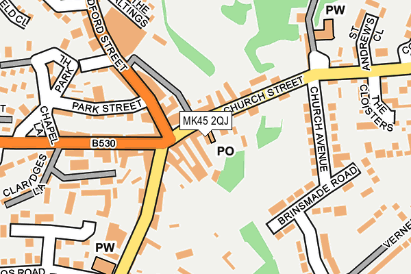
MK45 2QJ lies on Printers Court in Ampthill, Bedford. MK45 2QJ is located in the Ampthill electoral ward, within the unitary authority of Central Bedfordshire and the English Parliamentary constituency of Mid Bedfordshire. The Sub Integrated Care Board (ICB) Location is NHS Bedfordshire, Luton and Milton Keynes ICB - M1J4Y and the police force is Bedfordshire. This postcode has been in use since October 1985.


GetTheData
Source: OS OpenMap – Local (Ordnance Survey)
Source: OS VectorMap District (Ordnance Survey)
Licence: Open Government Licence (requires attribution)
| Easting | 503535 |
| Northing | 238117 |
| Latitude | 52.031818 |
| Longitude | -0.492175 |
GetTheData
Source: Open Postcode Geo
Licence: Open Government Licence
| Street | Printers Court |
| Locality | Ampthill |
| Town/City | Bedford |
| Country | England |
| Postcode District | MK45 |
| ➜ MK45 open data dashboard ➜ See where MK45 is on a map ➜ Where is Ampthill? | |
GetTheData
Source: Land Registry Price Paid Data
Licence: Open Government Licence
Elevation or altitude of MK45 2QJ as distance above sea level:
| Metres | Feet | |
|---|---|---|
| Elevation | 100m | 328ft |
Elevation is measured from the approximate centre of the postcode, to the nearest point on an OS contour line from OS Terrain 50, which has contour spacing of ten vertical metres.
➜ How high above sea level am I? Find the elevation of your current position using your device's GPS.
GetTheData
Source: Open Postcode Elevation
Licence: Open Government Licence
| Ward | Ampthill |
| Constituency | Mid Bedfordshire |
GetTheData
Source: ONS Postcode Database
Licence: Open Government Licence
| January 2024 | Anti-social behaviour | On or near Alameda Road | 426m |
| December 2023 | Public order | On or near Parking Area | 202m |
| May 2023 | Public order | On or near Parking Area | 202m |
| ➜ Get more crime data in our Crime section | |||
GetTheData
Source: data.police.uk
Licence: Open Government Licence
| Rectory Lane (Church Street) | Ampthill | 25m |
| Rectory Lane (Church Street) | Ampthill | 36m |
| Prince Of Wales (Bedford Street) | Ampthill | 128m |
| Prince Of Wales (Bedford Street) | Ampthill | 203m |
| Alameda Road (Woburn Street) | Ampthill | 282m |
| Flitwick Station | 3.1km |
| Millbrook (Beds) Station | 3.7km |
| Stewartby Station | 4.6km |
GetTheData
Source: NaPTAN
Licence: Open Government Licence
| Percentage of properties with Next Generation Access | 100.0% |
| Percentage of properties with Superfast Broadband | 100.0% |
| Percentage of properties with Ultrafast Broadband | 100.0% |
| Percentage of properties with Full Fibre Broadband | 0.0% |
Superfast Broadband is between 30Mbps and 300Mbps
Ultrafast Broadband is > 300Mbps
| Percentage of properties unable to receive 2Mbps | 0.0% |
| Percentage of properties unable to receive 5Mbps | 0.0% |
| Percentage of properties unable to receive 10Mbps | 0.0% |
| Percentage of properties unable to receive 30Mbps | 0.0% |
GetTheData
Source: Ofcom
Licence: Ofcom Terms of Use (requires attribution)
GetTheData
Source: ONS Postcode Database
Licence: Open Government Licence


➜ Get more ratings from the Food Standards Agency
GetTheData
Source: Food Standards Agency
Licence: FSA terms & conditions
| Last Collection | |||
|---|---|---|---|
| Location | Mon-Fri | Sat | Distance |
| Post Office Church Street | 18:10 | 10:30 | 27m |
| Bedford Street | 17:30 | 10:20 | 207m |
| Russell Drive | 17:30 | 10:45 | 923m |
GetTheData
Source: Dracos
Licence: Creative Commons Attribution-ShareAlike
| Facility | Distance |
|---|---|
| Russell Lower School Queens Road, Ampthill, Bedford Grass Pitches | 471m |
| Alameda Middle School Station Road, Ampthill, Bedford Sports Hall, Grass Pitches, Artificial Grass Pitch | 633m |
| Firs Lower School Station Road, Ampthill, Bedford Grass Pitches | 729m |
GetTheData
Source: Active Places
Licence: Open Government Licence
| School | Phase of Education | Distance |
|---|---|---|
| Russell Lower School Queens Road, Ampthill, MK45 2TD | Primary | 488m |
| Alameda Middle School Station Road, Ampthill, Bedford, MK45 2QR | Middle deemed secondary | 609m |
| The Firs Lower School Station Road, Ampthill, Bedford, MK45 2QR | Primary | 732m |
GetTheData
Source: Edubase
Licence: Open Government Licence
The below table lists the International Territorial Level (ITL) codes (formerly Nomenclature of Territorial Units for Statistics (NUTS) codes) and Local Administrative Units (LAU) codes for MK45 2QJ:
| ITL 1 Code | Name |
|---|---|
| TLH | East |
| ITL 2 Code | Name |
| TLH2 | Bedfordshire and Hertfordshire |
| ITL 3 Code | Name |
| TLH25 | Central Bedfordshire |
| LAU 1 Code | Name |
| E06000056 | Central Bedfordshire |
GetTheData
Source: ONS Postcode Directory
Licence: Open Government Licence
The below table lists the Census Output Area (OA), Lower Layer Super Output Area (LSOA), and Middle Layer Super Output Area (MSOA) for MK45 2QJ:
| Code | Name | |
|---|---|---|
| OA | E00087751 | |
| LSOA | E01017375 | Central Bedfordshire 012E |
| MSOA | E02003610 | Central Bedfordshire 012 |
GetTheData
Source: ONS Postcode Directory
Licence: Open Government Licence
| MK45 2PL | Church Street | 32m |
| MK45 2PJ | Church Street | 34m |
| MK45 2EH | Church Street | 53m |
| MK45 2GY | Bedford Street | 106m |
| MK45 2LU | Bedford Street | 113m |
| MK45 2JP | Dunstable Street | 126m |
| MK45 2NG | Dunstable Street | 130m |
| MK45 2HP | Woburn Street | 139m |
| MK45 2LR | Park Street | 168m |
| MK45 2PN | Church Avenue | 187m |
GetTheData
Source: Open Postcode Geo; Land Registry Price Paid Data
Licence: Open Government Licence