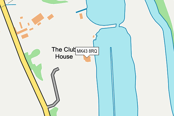
MK43 8RQ is located in the Wootton & Kempston Rural electoral ward, within the unitary authority of Bedford and the English Parliamentary constituency of Mid Bedfordshire. The Sub Integrated Care Board (ICB) Location is NHS Bedfordshire, Luton and Milton Keynes ICB - M1J4Y and the police force is Bedfordshire. This postcode has been in use since April 2014.


GetTheData
Source: OS OpenMap – Local (Ordnance Survey)
Source: OS VectorMap District (Ordnance Survey)
Licence: Open Government Licence (requires attribution)
| Easting | 501284 |
| Northing | 248482 |
| Latitude | 52.125379 |
| Longitude | -0.521926 |
GetTheData
Source: Open Postcode Geo
Licence: Open Government Licence
| Country | England |
| Postcode District | MK43 |
➜ See where MK43 is on a map | |
GetTheData
Source: Land Registry Price Paid Data
Licence: Open Government Licence
Elevation or altitude of MK43 8RQ as distance above sea level:
| Metres | Feet | |
|---|---|---|
| Elevation | 30m | 98ft |
Elevation is measured from the approximate centre of the postcode, to the nearest point on an OS contour line from OS Terrain 50, which has contour spacing of ten vertical metres.
➜ How high above sea level am I? Find the elevation of your current position using your device's GPS.
GetTheData
Source: Open Postcode Elevation
Licence: Open Government Licence
| Ward | Wootton & Kempston Rural |
| Constituency | Mid Bedfordshire |
GetTheData
Source: ONS Postcode Database
Licence: Open Government Licence
| Box End Road | Box End | 460m |
| Box End Road | Box End | 466m |
| Carnoustie Drive (Great Denham) | Great Denham | 532m |
| Bury Cottages (Cemetery Road) | Kempston Church End | 1,098m |
| Bury Cottages (Cemetery Road) | Kempston Church End | 1,100m |
| Bedford Station | 3.1km |
| Bedford St Johns Station | 3.8km |
| Kempston Hardwick Station | 3.9km |
GetTheData
Source: NaPTAN
Licence: Open Government Licence
GetTheData
Source: ONS Postcode Database
Licence: Open Government Licence


➜ Get more ratings from the Food Standards Agency
GetTheData
Source: Food Standards Agency
Licence: FSA terms & conditions
| Last Collection | |||
|---|---|---|---|
| Location | Mon-Fri | Sat | Distance |
| Kingswood Way | 17:30 | 11:10 | 549m |
| Church End | 16:05 | 07:00 | 706m |
| Box End | 16:00 | 07:10 | 718m |
GetTheData
Source: Dracos
Licence: Creative Commons Attribution-ShareAlike
| Risk of MK43 8RQ flooding from rivers and sea | Low |
| ➜ MK43 8RQ flood map | |
GetTheData
Source: Open Flood Risk by Postcode
Licence: Open Government Licence
The below table lists the International Territorial Level (ITL) codes (formerly Nomenclature of Territorial Units for Statistics (NUTS) codes) and Local Administrative Units (LAU) codes for MK43 8RQ:
| ITL 1 Code | Name |
|---|---|
| TLH | East |
| ITL 2 Code | Name |
| TLH2 | Bedfordshire and Hertfordshire |
| ITL 3 Code | Name |
| TLH24 | Bedford |
| LAU 1 Code | Name |
| E06000055 | Bedford |
GetTheData
Source: ONS Postcode Directory
Licence: Open Government Licence
The below table lists the Census Output Area (OA), Lower Layer Super Output Area (LSOA), and Middle Layer Super Output Area (MSOA) for MK43 8RQ:
| Code | Name | |
|---|---|---|
| OA | E00088573 | |
| LSOA | E01017547 | Bedford 002F |
| MSOA | E02003617 | Bedford 002 |
GetTheData
Source: ONS Postcode Directory
Licence: Open Government Licence
| MK40 4GE | Whitings | 410m |
| MK40 4SE | Midsummer Grove | 465m |
| MK40 4GB | Great Portway | 473m |
| MK43 8RP | Box End Road | 496m |
| MK43 8RR | Box End Road | 511m |
| MK40 4GA | Great Portway | 526m |
| MK40 4SA | Broad Mead Avenue | 551m |
| MK40 4FB | Muirfield | 553m |
| MK40 4FA | Lytham Place | 576m |
| MK40 4GD | Little Portway | 600m |
GetTheData
Source: Open Postcode Geo; Land Registry Price Paid Data
Licence: Open Government Licence