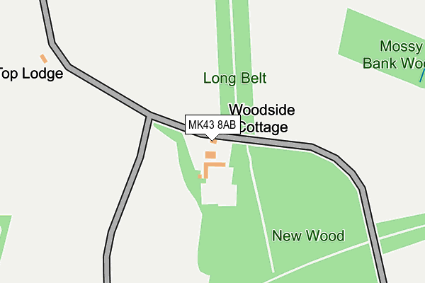
MK43 8AB is located in the Bromham electoral ward, within the unitary authority of Bedford and the English Parliamentary constituency of Mid Bedfordshire. The Sub Integrated Care Board (ICB) Location is NHS Bedfordshire, Luton and Milton Keynes ICB - M1J4Y and the police force is Bedfordshire. This postcode has been in use since January 1980.


GetTheData
Source: OS OpenMap – Local (Ordnance Survey)
Source: OS VectorMap District (Ordnance Survey)
Licence: Open Government Licence (requires attribution)
| Easting | 494157 |
| Northing | 250983 |
| Latitude | 52.149127 |
| Longitude | -0.625287 |
GetTheData
Source: Open Postcode Geo
Licence: Open Government Licence
| Country | England |
| Postcode District | MK43 |
| ➜ MK43 open data dashboard ➜ See where MK43 is on a map | |
GetTheData
Source: Land Registry Price Paid Data
Licence: Open Government Licence
Elevation or altitude of MK43 8AB as distance above sea level:
| Metres | Feet | |
|---|---|---|
| Elevation | 80m | 262ft |
Elevation is measured from the approximate centre of the postcode, to the nearest point on an OS contour line from OS Terrain 50, which has contour spacing of ten vertical metres.
➜ How high above sea level am I? Find the elevation of your current position using your device's GPS.
GetTheData
Source: Open Postcode Elevation
Licence: Open Government Licence
| Ward | Bromham |
| Constituency | Mid Bedfordshire |
GetTheData
Source: ONS Postcode Database
Licence: Open Government Licence
| The Laws (High Street) | Turvey | 1,440m |
| Turvey Abbey (High Street) | Turvey | 1,474m |
| Turvey Abbey (High Street) | Turvey | 1,485m |
| Brayfield House (Bedford Road A428) | Cold Brayfield | 1,632m |
| Brayfield House (Bedford Road A428) | Cold Brayfield | 1,654m |
GetTheData
Source: NaPTAN
Licence: Open Government Licence
| Percentage of properties with Next Generation Access | 100.0% |
| Percentage of properties with Superfast Broadband | 50.0% |
| Percentage of properties with Ultrafast Broadband | 0.0% |
| Percentage of properties with Full Fibre Broadband | 0.0% |
Superfast Broadband is between 30Mbps and 300Mbps
Ultrafast Broadband is > 300Mbps
| Percentage of properties unable to receive 2Mbps | 0.0% |
| Percentage of properties unable to receive 5Mbps | 0.0% |
| Percentage of properties unable to receive 10Mbps | 50.0% |
| Percentage of properties unable to receive 30Mbps | 50.0% |
GetTheData
Source: Ofcom
Licence: Ofcom Terms of Use (requires attribution)
GetTheData
Source: ONS Postcode Database
Licence: Open Government Licence


➜ Get more ratings from the Food Standards Agency
GetTheData
Source: Food Standards Agency
Licence: FSA terms & conditions
| Last Collection | |||
|---|---|---|---|
| Location | Mon-Fri | Sat | Distance |
| Tandys Close | 16:30 | 09:30 | 1,247m |
| Bedford Road | 17:30 | 10:15 | 1,492m |
| Turvey Loop | 17:20 | 11:00 | 1,539m |
GetTheData
Source: Dracos
Licence: Creative Commons Attribution-ShareAlike
| Facility | Distance |
|---|---|
| Turvey Primary School May Road, Turvey, Bedford Sports Hall, Grass Pitches | 1.7km |
| Turvey Playing Fields Grove Road, Turvey Grass Pitches, Outdoor Tennis Courts | 1.9km |
| Emmaus Village Carlton School Lane, Carlton, Bedford Grass Pitches | 3.6km |
GetTheData
Source: Active Places
Licence: Open Government Licence
| School | Phase of Education | Distance |
|---|---|---|
| Newton Blossomville Church of England School Newton Blossomville, Turvey, Bedford, MK43 8AL | Primary | 1.7km |
| Turvey Primary School May Road, Turvey, Bedford, MK43 8DY | Primary | 1.7km |
| Lavendon School High Street, Lavendon, Olney, MK46 4HA | Primary | 3.5km |
GetTheData
Source: Edubase
Licence: Open Government Licence
The below table lists the International Territorial Level (ITL) codes (formerly Nomenclature of Territorial Units for Statistics (NUTS) codes) and Local Administrative Units (LAU) codes for MK43 8AB:
| ITL 1 Code | Name |
|---|---|
| TLH | East |
| ITL 2 Code | Name |
| TLH2 | Bedfordshire and Hertfordshire |
| ITL 3 Code | Name |
| TLH24 | Bedford |
| LAU 1 Code | Name |
| E06000055 | Bedford |
GetTheData
Source: ONS Postcode Directory
Licence: Open Government Licence
The below table lists the Census Output Area (OA), Lower Layer Super Output Area (LSOA), and Middle Layer Super Output Area (MSOA) for MK43 8AB:
| Code | Name | |
|---|---|---|
| OA | E00088575 | |
| LSOA | E01017546 | Bedford 002E |
| MSOA | E02003617 | Bedford 002 |
GetTheData
Source: ONS Postcode Directory
Licence: Open Government Licence
| MK43 8GJ | Bakers Close | 1183m |
| MK43 8HA | Newton Lane | 1259m |
| MK43 8EU | Tandys Close | 1281m |
| MK43 8ET | Mill Green | 1318m |
| MK43 8EW | The Mill | 1353m |
| MK43 8HB | Ladybridge Terrace | 1382m |
| MK43 8DH | Jacks Lane | 1393m |
| MK43 8ER | Bridge Street | 1426m |
| MK43 8DA | The Green | 1436m |
| MK43 8DD | Covingtons Yard | 1439m |
GetTheData
Source: Open Postcode Geo; Land Registry Price Paid Data
Licence: Open Government Licence