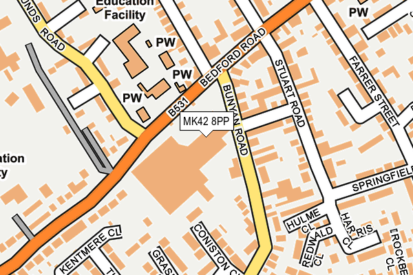
MK42 8PP is located in the Kempston Central & East electoral ward, within the unitary authority of Bedford and the English Parliamentary constituency of Bedford. The Sub Integrated Care Board (ICB) Location is NHS Bedfordshire, Luton and Milton Keynes ICB - M1J4Y and the police force is Bedfordshire. This postcode has been in use since January 1980.


GetTheData
Source: OS OpenMap – Local (Ordnance Survey)
Source: OS VectorMap District (Ordnance Survey)
Licence: Open Government Licence (requires attribution)
| Easting | 503134 |
| Northing | 247674 |
| Latitude | 52.117787 |
| Longitude | -0.495135 |
GetTheData
Source: Open Postcode Geo
Licence: Open Government Licence
| Country | England |
| Postcode District | MK42 |
| ➜ MK42 open data dashboard ➜ See where MK42 is on a map ➜ Where is Kempston? | |
GetTheData
Source: Land Registry Price Paid Data
Licence: Open Government Licence
Elevation or altitude of MK42 8PP as distance above sea level:
| Metres | Feet | |
|---|---|---|
| Elevation | 30m | 98ft |
Elevation is measured from the approximate centre of the postcode, to the nearest point on an OS contour line from OS Terrain 50, which has contour spacing of ten vertical metres.
➜ How high above sea level am I? Find the elevation of your current position using your device's GPS.
GetTheData
Source: Open Postcode Elevation
Licence: Open Government Licence
| Ward | Kempston Central & East |
| Constituency | Bedford |
GetTheData
Source: ONS Postcode Database
Licence: Open Government Licence
| January 2024 | Vehicle crime | On or near Duncombe Street | 432m |
| January 2024 | Violence and sexual offences | On or near The Glen | 483m |
| January 2024 | Public order | On or near The Glen | 483m |
| ➜ Get more crime data in our Crime section | |||
GetTheData
Source: data.police.uk
Licence: Open Government Licence
| Bunyan Road | Kempston | 59m |
| Bunyan Road | Kempston | 77m |
| Saxon Centre (Bedford Road) | Kempston | 84m |
| Saxon Centre (Bedford Road) | Kempston | 92m |
| Bedford Road Lower School (Hillgrounds Road) | Kempston | 136m |
| Bedford St Johns Station | 2.3km |
| Bedford Station | 2.3km |
| Kempston Hardwick Station | 2.9km |
GetTheData
Source: NaPTAN
Licence: Open Government Licence
GetTheData
Source: ONS Postcode Database
Licence: Open Government Licence


➜ Get more ratings from the Food Standards Agency
GetTheData
Source: Food Standards Agency
Licence: FSA terms & conditions
| Last Collection | |||
|---|---|---|---|
| Location | Mon-Fri | Sat | Distance |
| Bedford Road | 17:30 | 11:30 | 215m |
| Farrer Street | 17:30 | 11:30 | 368m |
| Post Office St Johns Street | 17:30 | 11:45 | 426m |
GetTheData
Source: Dracos
Licence: Creative Commons Attribution-ShareAlike
| Facility | Distance |
|---|---|
| Kempston East Methodist Church Bedford Road, Kempston, Bedford Sports Hall | 239m |
| Robert Bruce Middle School (Closed) Bedford Road, Kempston, Bedford Grass Pitches | 344m |
| Grange Academy Halsey Road, Kempston, Bedford Grass Pitches, Health and Fitness Gym, Sports Hall | 510m |
GetTheData
Source: Active Places
Licence: Open Government Licence
| School | Phase of Education | Distance |
|---|---|---|
| Bedford Road Primary Academy Hillgrounds Road, Kempston, Bedford, MK42 8QH | Primary | 170m |
| Greys Education Centre Manor Drive, Kempston, Bedford, MK42 7AB | Not applicable | 391m |
| Grange Academy Halsey Road, Kempston, Bedford, MK42 8AU | Not applicable | 510m |
GetTheData
Source: Edubase
Licence: Open Government Licence
The below table lists the International Territorial Level (ITL) codes (formerly Nomenclature of Territorial Units for Statistics (NUTS) codes) and Local Administrative Units (LAU) codes for MK42 8PP:
| ITL 1 Code | Name |
|---|---|
| TLH | East |
| ITL 2 Code | Name |
| TLH2 | Bedfordshire and Hertfordshire |
| ITL 3 Code | Name |
| TLH24 | Bedford |
| LAU 1 Code | Name |
| E06000055 | Bedford |
GetTheData
Source: ONS Postcode Directory
Licence: Open Government Licence
The below table lists the Census Output Area (OA), Lower Layer Super Output Area (LSOA), and Middle Layer Super Output Area (MSOA) for MK42 8PP:
| Code | Name | |
|---|---|---|
| OA | E00088388 | |
| LSOA | E01017505 | Bedford 017A |
| MSOA | E02003632 | Bedford 017 |
GetTheData
Source: ONS Postcode Directory
Licence: Open Government Licence
| MK42 8HP | Bunyan Road | 80m |
| MK42 8HR | Tempsford Street | 94m |
| MK42 8HL | Bunyan Road | 105m |
| MK42 8QB | Bedford Road | 107m |
| MK42 8JT | Coniston Close | 130m |
| MK42 8HS | Stuart Road | 147m |
| MK42 8HN | Hulme Close | 158m |
| MK42 8HA | Bunyan Road | 167m |
| MK42 8BL | Bedford Road | 181m |
| MK42 8QH | Hillgrounds Road | 192m |
GetTheData
Source: Open Postcode Geo; Land Registry Price Paid Data
Licence: Open Government Licence