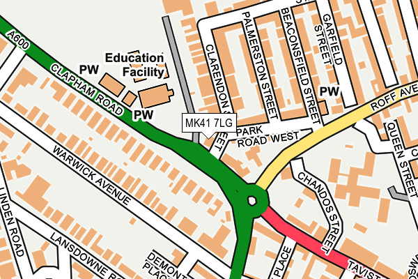
MK41 7LG lies on Clapham Road in Bedford. MK41 7LG is located in the Harpur electoral ward, within the unitary authority of Bedford and the English Parliamentary constituency of Bedford. The Sub Integrated Care Board (ICB) Location is NHS Bedfordshire, Luton and Milton Keynes ICB - M1J4Y and the police force is Bedfordshire. This postcode has been in use since January 1980.


GetTheData
Source: OS OpenMap – Local (Ordnance Survey)
Source: OS VectorMap District (Ordnance Survey)
Licence: Open Government Licence (requires attribution)
| Easting | 504443 |
| Northing | 250489 |
| Latitude | 52.142841 |
| Longitude | -0.475161 |
GetTheData
Source: Open Postcode Geo
Licence: Open Government Licence
| Street | Clapham Road |
| Town/City | Bedford |
| Country | England |
| Postcode District | MK41 |
| ➜ MK41 open data dashboard ➜ See where MK41 is on a map ➜ Where is Bedford? | |
GetTheData
Source: Land Registry Price Paid Data
Licence: Open Government Licence
Elevation or altitude of MK41 7LG as distance above sea level:
| Metres | Feet | |
|---|---|---|
| Elevation | 40m | 131ft |
Elevation is measured from the approximate centre of the postcode, to the nearest point on an OS contour line from OS Terrain 50, which has contour spacing of ten vertical metres.
➜ How high above sea level am I? Find the elevation of your current position using your device's GPS.
GetTheData
Source: Open Postcode Elevation
Licence: Open Government Licence
| Ward | Harpur |
| Constituency | Bedford |
GetTheData
Source: ONS Postcode Database
Licence: Open Government Licence
| November 2023 | Burglary | On or near Boswell Place | 368m |
| November 2023 | Other theft | On or near Boswell Place | 368m |
| October 2023 | Other theft | On or near Boswell Place | 368m |
| ➜ Get more crime data in our Crime section | |||
GetTheData
Source: data.police.uk
Licence: Open Government Licence
| Livingstone Lower School (Clapham Road) | Bedford | 50m |
| Chandos Street (Roff Avenue) | Bedford | 106m |
| Warwick Avenue | Bedford | 146m |
| Aspley Court (Warwick Avenue) | Bedford | 154m |
| Lansdowne Road (Union Street) | Bedford | 193m |
| Bedford Station | 0.8km |
| Bedford St Johns Station | 1.6km |
GetTheData
Source: NaPTAN
Licence: Open Government Licence
| Percentage of properties with Next Generation Access | 100.0% |
| Percentage of properties with Superfast Broadband | 100.0% |
| Percentage of properties with Ultrafast Broadband | 100.0% |
| Percentage of properties with Full Fibre Broadband | 0.0% |
Superfast Broadband is between 30Mbps and 300Mbps
Ultrafast Broadband is > 300Mbps
| Percentage of properties unable to receive 2Mbps | 0.0% |
| Percentage of properties unable to receive 5Mbps | 0.0% |
| Percentage of properties unable to receive 10Mbps | 0.0% |
| Percentage of properties unable to receive 30Mbps | 0.0% |
GetTheData
Source: Ofcom
Licence: Ofcom Terms of Use (requires attribution)
GetTheData
Source: ONS Postcode Database
Licence: Open Government Licence


➜ Get more ratings from the Food Standards Agency
GetTheData
Source: Food Standards Agency
Licence: FSA terms & conditions
| Last Collection | |||
|---|---|---|---|
| Location | Mon-Fri | Sat | Distance |
| Landsdowne Road | 18:30 | 11:45 | 244m |
| Stanley Street | 18:40 | 12:25 | 257m |
| Linden Road | 18:30 | 11:45 | 324m |
GetTheData
Source: Dracos
Licence: Creative Commons Attribution-ShareAlike
| Facility | Distance |
|---|---|
| University Of Bedfordshire (Lansdowne Road Campus) (Closed) Lansdowne Road, Bedford Sports Hall, Swimming Pool | 239m |
| Polam Swim School Lansdowne Road, Bedford Swimming Pool | 264m |
| Linden Road Tennis Courts Linden Road, Bedford Outdoor Tennis Courts | 334m |
GetTheData
Source: Active Places
Licence: Open Government Licence
| School | Phase of Education | Distance |
|---|---|---|
| Livingstone Primary School Clapham Road, Bedford, MK41 7LG | Primary | 104m |
| Polam School 45 Lansdowne Road, Bedford, MK40 2BU | Not applicable | 272m |
| Bedford Greenacre Independent School 58-60 Shakespeare Rd, Bedford, MK40 2DL | Not applicable | 507m |
GetTheData
Source: Edubase
Licence: Open Government Licence
The below table lists the International Territorial Level (ITL) codes (formerly Nomenclature of Territorial Units for Statistics (NUTS) codes) and Local Administrative Units (LAU) codes for MK41 7LG:
| ITL 1 Code | Name |
|---|---|
| TLH | East |
| ITL 2 Code | Name |
| TLH2 | Bedfordshire and Hertfordshire |
| ITL 3 Code | Name |
| TLH24 | Bedford |
| LAU 1 Code | Name |
| E06000055 | Bedford |
GetTheData
Source: ONS Postcode Directory
Licence: Open Government Licence
The below table lists the Census Output Area (OA), Lower Layer Super Output Area (LSOA), and Middle Layer Super Output Area (MSOA) for MK41 7LG:
| Code | Name | |
|---|---|---|
| OA | E00088348 | |
| LSOA | E01017500 | Bedford 010D |
| MSOA | E02003625 | Bedford 010 |
GetTheData
Source: ONS Postcode Directory
Licence: Open Government Licence
| MK41 7DP | Clarendon Street | 53m |
| MK41 7PP | Clapham Road | 63m |
| MK40 2SD | Tavistock Street | 66m |
| MK41 7SG | Park Road West | 78m |
| MK41 7SL | Park Road West | 87m |
| MK41 7SQ | Clarendon Street | 101m |
| MK41 7SJ | Clarendon Street | 111m |
| MK40 2EE | Warwick Avenue | 118m |
| MK41 7SB | Park Road West | 129m |
| MK41 7SE | Palmerston Street | 140m |
GetTheData
Source: Open Postcode Geo; Land Registry Price Paid Data
Licence: Open Government Licence