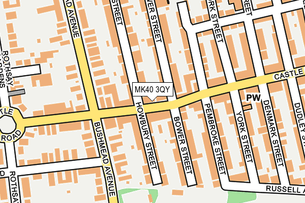
MK40 3QY lies on Castle Road in Bedford. MK40 3QY is located in the Castle & Newnham electoral ward, within the unitary authority of Bedford and the English Parliamentary constituency of Bedford. The Sub Integrated Care Board (ICB) Location is NHS Bedfordshire, Luton and Milton Keynes ICB - M1J4Y and the police force is Bedfordshire. This postcode has been in use since January 1980.


GetTheData
Source: OS OpenMap – Local (Ordnance Survey)
Source: OS VectorMap District (Ordnance Survey)
Licence: Open Government Licence (requires attribution)
| Easting | 505887 |
| Northing | 249888 |
| Latitude | 52.137165 |
| Longitude | -0.454255 |
GetTheData
Source: Open Postcode Geo
Licence: Open Government Licence
| Street | Castle Road |
| Town/City | Bedford |
| Country | England |
| Postcode District | MK40 |
| ➜ MK40 open data dashboard ➜ See where MK40 is on a map ➜ Where is Bedford? | |
GetTheData
Source: Land Registry Price Paid Data
Licence: Open Government Licence
Elevation or altitude of MK40 3QY as distance above sea level:
| Metres | Feet | |
|---|---|---|
| Elevation | 30m | 98ft |
Elevation is measured from the approximate centre of the postcode, to the nearest point on an OS contour line from OS Terrain 50, which has contour spacing of ten vertical metres.
➜ How high above sea level am I? Find the elevation of your current position using your device's GPS.
GetTheData
Source: Open Postcode Elevation
Licence: Open Government Licence
| Ward | Castle & Newnham |
| Constituency | Bedford |
GetTheData
Source: ONS Postcode Database
Licence: Open Government Licence
| June 2022 | Violence and sexual offences | On or near Castle Road | 85m |
| June 2022 | Public order | On or near Castle Road | 85m |
| June 2022 | Other theft | On or near Pembroke Street | 108m |
| ➜ Get more crime data in our Crime section | |||
GetTheData
Source: data.police.uk
Licence: Open Government Licence
| Howbury Street (Castle Road) | Bedford | 13m |
| Howbury Street (Castle Road) | Bedford | 47m |
| Dudley Street (Castle Road) | Bedford | 252m |
| Dudley Street (Castle Road) | Bedford | 283m |
| Goldington Avenue (Goldington Road) | Bedford | 325m |
| Bedford St Johns Station | 1.2km |
| Bedford Station | 1.7km |
GetTheData
Source: NaPTAN
Licence: Open Government Licence
GetTheData
Source: ONS Postcode Database
Licence: Open Government Licence


➜ Get more ratings from the Food Standards Agency
GetTheData
Source: Food Standards Agency
Licence: FSA terms & conditions
| Last Collection | |||
|---|---|---|---|
| Location | Mon-Fri | Sat | Distance |
| Post Office Pembroke Street | 18:40 | 12:20 | 101m |
| Rothsay Gardens | 18:55 | 12:35 | 319m |
| Bushmead Avenue | 18:45 | 12:15 | 333m |
GetTheData
Source: Dracos
Licence: Creative Commons Attribution-ShareAlike
| Facility | Distance |
|---|---|
| Russell Park (Bedford) The Embankment, Bedford Grass Pitches, Outdoor Tennis Courts | 305m |
| Riverside Tennis Club (Bedford) Goldington Road, Bedford Indoor Tennis Centre, Outdoor Tennis Courts | 429m |
| Bedford Blues (Goldington Road) Goldington Road, Bedford Grass Pitches | 497m |
GetTheData
Source: Active Places
Licence: Open Government Licence
| School | Phase of Education | Distance |
|---|---|---|
| Castle Newnham School Goldington Road, Bedford, MK40 3EP | Primary | 293m |
| Bedford Girls' School Cardington Road, Bedford, MK42 0BX | Not applicable | 700m |
| Bedford School De Parys Avenue, Bedford, MK40 2TU | Not applicable | 793m |
GetTheData
Source: Edubase
Licence: Open Government Licence
The below table lists the International Territorial Level (ITL) codes (formerly Nomenclature of Territorial Units for Statistics (NUTS) codes) and Local Administrative Units (LAU) codes for MK40 3QY:
| ITL 1 Code | Name |
|---|---|
| TLH | East |
| ITL 2 Code | Name |
| TLH2 | Bedfordshire and Hertfordshire |
| ITL 3 Code | Name |
| TLH24 | Bedford |
| LAU 1 Code | Name |
| E06000055 | Bedford |
GetTheData
Source: ONS Postcode Directory
Licence: Open Government Licence
The below table lists the Census Output Area (OA), Lower Layer Super Output Area (LSOA), and Middle Layer Super Output Area (MSOA) for MK40 3QY:
| Code | Name | |
|---|---|---|
| OA | E00088207 | |
| LSOA | E01017467 | Bedford 012B |
| MSOA | E02003627 | Bedford 012 |
GetTheData
Source: ONS Postcode Directory
Licence: Open Government Licence
| MK40 3QX | Castle Road | 27m |
| MK40 3QP | Castle Road | 68m |
| MK40 3QR | Castle Road | 70m |
| MK40 3RG | Castle Road | 81m |
| MK40 3RF | Castle Road | 83m |
| MK40 3RB | Bower Street | 87m |
| MK40 3QU | Howbury Street | 98m |
| MK40 3RE | Bower Street | 106m |
| MK40 3RQ | Pembroke Street | 109m |
| MK40 3RD | Bower Street | 117m |
GetTheData
Source: Open Postcode Geo; Land Registry Price Paid Data
Licence: Open Government Licence