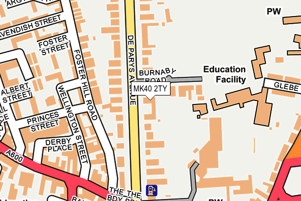
MK40 2TY is located in the De Parys electoral ward, within the unitary authority of Bedford and the English Parliamentary constituency of Bedford. The Sub Integrated Care Board (ICB) Location is NHS Bedfordshire, Luton and Milton Keynes ICB - M1J4Y and the police force is Bedfordshire. This postcode has been in use since January 1980.


GetTheData
Source: OS OpenMap – Local (Ordnance Survey)
Source: OS VectorMap District (Ordnance Survey)
Licence: Open Government Licence (requires attribution)
| Easting | 505054 |
| Northing | 250347 |
| Latitude | 52.141437 |
| Longitude | -0.466301 |
GetTheData
Source: Open Postcode Geo
Licence: Open Government Licence
| Country | England |
| Postcode District | MK40 |
| ➜ MK40 open data dashboard ➜ See where MK40 is on a map ➜ Where is Bedford? | |
GetTheData
Source: Land Registry Price Paid Data
Licence: Open Government Licence
Elevation or altitude of MK40 2TY as distance above sea level:
| Metres | Feet | |
|---|---|---|
| Elevation | 30m | 98ft |
Elevation is measured from the approximate centre of the postcode, to the nearest point on an OS contour line from OS Terrain 50, which has contour spacing of ten vertical metres.
➜ How high above sea level am I? Find the elevation of your current position using your device's GPS.
GetTheData
Source: Open Postcode Elevation
Licence: Open Government Licence
| Ward | De Parys |
| Constituency | Bedford |
GetTheData
Source: ONS Postcode Database
Licence: Open Government Licence
| January 2024 | Other theft | On or near Parking Area | 341m |
| January 2024 | Bicycle theft | On or near Nightclub | 355m |
| January 2024 | Other theft | On or near Nightclub | 355m |
| ➜ Get more crime data in our Crime section | |||
GetTheData
Source: data.police.uk
Licence: Open Government Licence
| The Broadway (De Parys Avenue) | Bedford | 251m |
| St Peter's Street | Bedford | 288m |
| St Peter's Street | Bedford | 295m |
| Bedford Hospital North Wing (Kimbolton Road) | Bedford | 328m |
| Merton Centre (St Cuthberts Street) | Bedford | 334m |
| Bedford Station | 1.1km |
| Bedford St Johns Station | 1.3km |
GetTheData
Source: NaPTAN
Licence: Open Government Licence
GetTheData
Source: ONS Postcode Database
Licence: Open Government Licence


➜ Get more ratings from the Food Standards Agency
GetTheData
Source: Food Standards Agency
Licence: FSA terms & conditions
| Last Collection | |||
|---|---|---|---|
| Location | Mon-Fri | Sat | Distance |
| The Broadway | 19:00 | 11:55 | 198m |
| De Parys Avenue | 18:45 | 12:15 | 217m |
| St Peters Street | 18:20 | 12:00 | 282m |
GetTheData
Source: Dracos
Licence: Creative Commons Attribution-ShareAlike
| Facility | Distance |
|---|---|
| Bedford School De Parys Avenue, Bedford Health and Fitness Gym, Grass Pitches, Sports Hall, Swimming Pool, Squash Courts, Outdoor Tennis Courts | 191m |
| Hmp Bedford St. Loyes Street, Bedford Artificial Grass Pitch | 357m |
| Trinity Arts & Leisure Bromham Road, Bedford Sports Hall, Swimming Pool, Health and Fitness Gym, Studio | 426m |
GetTheData
Source: Active Places
Licence: Open Government Licence
| School | Phase of Education | Distance |
|---|---|---|
| Bedford School De Parys Avenue, Bedford, MK40 2TU | Not applicable | 191m |
| Priory Primary School Greyfriars, Bedford, MK40 1JD | Primary | 716m |
| Livingstone Primary School Clapham Road, Bedford, MK41 7LG | Primary | 723m |
GetTheData
Source: Edubase
Licence: Open Government Licence
The below table lists the International Territorial Level (ITL) codes (formerly Nomenclature of Territorial Units for Statistics (NUTS) codes) and Local Administrative Units (LAU) codes for MK40 2TY:
| ITL 1 Code | Name |
|---|---|
| TLH | East |
| ITL 2 Code | Name |
| TLH2 | Bedfordshire and Hertfordshire |
| ITL 3 Code | Name |
| TLH24 | Bedford |
| LAU 1 Code | Name |
| E06000055 | Bedford |
GetTheData
Source: ONS Postcode Directory
Licence: Open Government Licence
The below table lists the Census Output Area (OA), Lower Layer Super Output Area (LSOA), and Middle Layer Super Output Area (MSOA) for MK40 2TY:
| Code | Name | |
|---|---|---|
| OA | E00088283 | |
| LSOA | E01017484 | Bedford 009C |
| MSOA | E02003624 | Bedford 009 |
GetTheData
Source: ONS Postcode Directory
Licence: Open Government Licence
| MK40 2TW | De Parys Avenue | 64m |
| MK40 2TX | De Parys Avenue | 103m |
| MK40 2EN | Foster Hill Road | 128m |
| MK40 2FE | Foster Hill Road | 138m |
| MK40 2UA | De Parys Avenue | 147m |
| MK40 2ES | Foster Hill Road | 150m |
| MK40 2HY | Wellington Street | 153m |
| MK40 2FF | Wellington Street | 168m |
| MK40 2TZ | De Parys Avenue | 170m |
| MK40 2ET | Foster Hill Road | 180m |
GetTheData
Source: Open Postcode Geo; Land Registry Price Paid Data
Licence: Open Government Licence