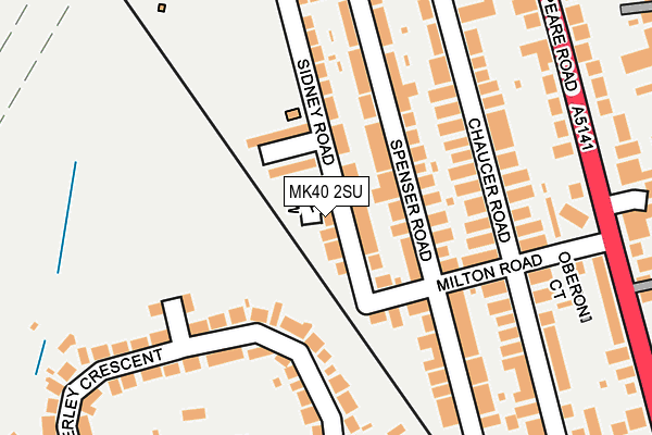
MK40 2SU lies on Sidney Road in Bedford. MK40 2SU is located in the Harpur electoral ward, within the unitary authority of Bedford and the English Parliamentary constituency of Bedford. The Sub Integrated Care Board (ICB) Location is NHS Bedfordshire, Luton and Milton Keynes ICB - M1J4Y and the police force is Bedfordshire. This postcode has been in use since January 1980.


GetTheData
Source: OS OpenMap – Local (Ordnance Survey)
Source: OS VectorMap District (Ordnance Survey)
Licence: Open Government Licence (requires attribution)
| Easting | 503799 |
| Northing | 250323 |
| Latitude | 52.141459 |
| Longitude | -0.484641 |
GetTheData
Source: Open Postcode Geo
Licence: Open Government Licence
| Street | Sidney Road |
| Town/City | Bedford |
| Country | England |
| Postcode District | MK40 |
| ➜ MK40 open data dashboard ➜ See where MK40 is on a map ➜ Where is Bedford? | |
GetTheData
Source: Land Registry Price Paid Data
Licence: Open Government Licence
Elevation or altitude of MK40 2SU as distance above sea level:
| Metres | Feet | |
|---|---|---|
| Elevation | 30m | 98ft |
Elevation is measured from the approximate centre of the postcode, to the nearest point on an OS contour line from OS Terrain 50, which has contour spacing of ten vertical metres.
➜ How high above sea level am I? Find the elevation of your current position using your device's GPS.
GetTheData
Source: Open Postcode Elevation
Licence: Open Government Licence
| Ward | Harpur |
| Constituency | Bedford |
GetTheData
Source: ONS Postcode Database
Licence: Open Government Licence
| June 2022 | Vehicle crime | On or near Spenser Road | 87m |
| June 2022 | Violence and sexual offences | On or near Milton Road | 153m |
| June 2022 | Violence and sexual offences | On or near Chaucer Road | 157m |
| ➜ Sidney Road crime map and outcomes | |||
GetTheData
Source: data.police.uk
Licence: Open Government Licence
| Alexander Sports Centre (Cowper Road) | Bedford | 224m |
| Cutcliffe Grove (Bromham Road) | Bedford | 260m |
| Cutcliffe Grove (Bromham Road) | Bedford | 261m |
| Cowper Road | Bedford | 287m |
| Cowper Road | Bedford | 301m |
| Bedford Station | 0.7km |
| Bedford St Johns Station | 1.8km |
GetTheData
Source: NaPTAN
Licence: Open Government Licence
| Percentage of properties with Next Generation Access | 100.0% |
| Percentage of properties with Superfast Broadband | 100.0% |
| Percentage of properties with Ultrafast Broadband | 100.0% |
| Percentage of properties with Full Fibre Broadband | 0.0% |
Superfast Broadband is between 30Mbps and 300Mbps
Ultrafast Broadband is > 300Mbps
| Percentage of properties unable to receive 2Mbps | 0.0% |
| Percentage of properties unable to receive 5Mbps | 0.0% |
| Percentage of properties unable to receive 10Mbps | 0.0% |
| Percentage of properties unable to receive 30Mbps | 0.0% |
GetTheData
Source: Ofcom
Licence: Ofcom Terms of Use (requires attribution)
GetTheData
Source: ONS Postcode Database
Licence: Open Government Licence


➜ Get more ratings from the Food Standards Agency
GetTheData
Source: Food Standards Agency
Licence: FSA terms & conditions
| Last Collection | |||
|---|---|---|---|
| Location | Mon-Fri | Sat | Distance |
| Milton Road | 18:30 | 12:00 | 184m |
| Shakespeare Road | 19:00 | 11:55 | 286m |
| Linden Road | 18:30 | 11:45 | 410m |
GetTheData
Source: Dracos
Licence: Creative Commons Attribution-ShareAlike
| Facility | Distance |
|---|---|
| Bedford Girls' School Playing Fields (Closed) Beverley Grove, Bedford Grass Pitches, Outdoor Tennis Courts | 182m |
| Alexander Sports Centre Sidney Road, Bedford Sports Hall, Health and Fitness Gym, Grass Pitches | 257m |
| Bedford Greenacre Independent School (Shakespeare Road) Shakespeare Road, Bedford Sports Hall | 339m |
GetTheData
Source: Active Places
Licence: Open Government Licence
| School | Phase of Education | Distance |
|---|---|---|
| Bedford Greenacre Independent School 58-60 Shakespeare Rd, Bedford, MK40 2DL | Not applicable | 338m |
| Great Ouse Primary Academy Seaforth Gardens, Bedford, MK40 4TJ | Primary | 523m |
| Polam School 45 Lansdowne Road, Bedford, MK40 2BU | Not applicable | 533m |
GetTheData
Source: Edubase
Licence: Open Government Licence
The below table lists the International Territorial Level (ITL) codes (formerly Nomenclature of Territorial Units for Statistics (NUTS) codes) and Local Administrative Units (LAU) codes for MK40 2SU:
| ITL 1 Code | Name |
|---|---|
| TLH | East |
| ITL 2 Code | Name |
| TLH2 | Bedfordshire and Hertfordshire |
| ITL 3 Code | Name |
| TLH24 | Bedford |
| LAU 1 Code | Name |
| E06000055 | Bedford |
GetTheData
Source: ONS Postcode Directory
Licence: Open Government Licence
The below table lists the Census Output Area (OA), Lower Layer Super Output Area (LSOA), and Middle Layer Super Output Area (MSOA) for MK40 2SU:
| Code | Name | |
|---|---|---|
| OA | E00088344 | |
| LSOA | E01017499 | Bedford 010C |
| MSOA | E02003625 | Bedford 010 |
GetTheData
Source: ONS Postcode Directory
Licence: Open Government Licence
| MK40 2BG | Sidney Road | 29m |
| MK40 2TD | Milne Row | 30m |
| MK40 2BQ | Sidney Road | 74m |
| MK40 2BB | Spenser Road | 81m |
| MK40 2TB | Chesterton Mews | 87m |
| MK40 2BE | Spenser Road | 103m |
| MK40 2AY | Milton Road | 105m |
| MK40 4BX | Beverley Crescent | 114m |
| MK40 2AX | Milton Road | 136m |
| MK40 2AP | Chaucer Road | 140m |
GetTheData
Source: Open Postcode Geo; Land Registry Price Paid Data
Licence: Open Government Licence