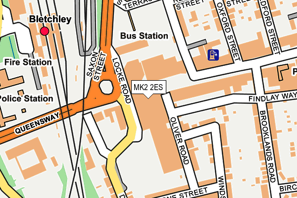
MK2 2ES is located in the Bletchley Park electoral ward, within the unitary authority of Milton Keynes and the English Parliamentary constituency of Milton Keynes South. The Sub Integrated Care Board (ICB) Location is NHS Bedfordshire, Luton and Milton Keynes ICB - M1J4Y and the police force is Thames Valley. This postcode has been in use since April 1985.


GetTheData
Source: OS OpenMap – Local (Ordnance Survey)
Source: OS VectorMap District (Ordnance Survey)
Licence: Open Government Licence (requires attribution)
| Easting | 487064 |
| Northing | 233605 |
| Latitude | 51.994078 |
| Longitude | -0.733370 |
GetTheData
Source: Open Postcode Geo
Licence: Open Government Licence
| Country | England |
| Postcode District | MK2 |
| ➜ MK2 open data dashboard ➜ See where MK2 is on a map ➜ Where is Bletchley? | |
GetTheData
Source: Land Registry Price Paid Data
Licence: Open Government Licence
Elevation or altitude of MK2 2ES as distance above sea level:
| Metres | Feet | |
|---|---|---|
| Elevation | 80m | 262ft |
Elevation is measured from the approximate centre of the postcode, to the nearest point on an OS contour line from OS Terrain 50, which has contour spacing of ten vertical metres.
➜ How high above sea level am I? Find the elevation of your current position using your device's GPS.
GetTheData
Source: Open Postcode Elevation
Licence: Open Government Licence
| Ward | Bletchley Park |
| Constituency | Milton Keynes South |
GetTheData
Source: ONS Postcode Database
Licence: Open Government Licence
| January 2024 | Violence and sexual offences | On or near Parking Area | 418m |
| November 2023 | Violence and sexual offences | On or near Princes Way | 391m |
| November 2023 | Other crime | On or near Parking Area | 418m |
| ➜ Get more crime data in our Crime section | |||
GetTheData
Source: data.police.uk
Licence: Open Government Licence
| Stanier Square (Queensway) | Bletchley | 147m |
| Findlay Way (Brooklands Road) | Bletchley | 219m |
| Bletchley Police Station (Buckingham Road) | Bletchley Park | 270m |
| Bletchley Police Station (Buckingham Road) | Bletchley Park | 288m |
| Bletchley Railway Station (Sherwood Drive) | Bletchley Park | 323m |
| Bletchley Station | 0.2km |
| Fenny Stratford Station | 1.4km |
| Bow Brickhill Station | 2.8km |
GetTheData
Source: NaPTAN
Licence: Open Government Licence
GetTheData
Source: ONS Postcode Database
Licence: Open Government Licence


➜ Get more ratings from the Food Standards Agency
GetTheData
Source: Food Standards Agency
Licence: FSA terms & conditions
| Last Collection | |||
|---|---|---|---|
| Location | Mon-Fri | Sat | Distance |
| Stanier Square | 18:30 | 12:00 | 42m |
| Post Office Queensway | 18:30 | 13:00 | 271m |
| Post Office Queensway | 18:30 | 13:00 | 275m |
GetTheData
Source: Dracos
Licence: Creative Commons Attribution-ShareAlike
| Facility | Distance |
|---|---|
| Courtside Sports & Fitness @ Milton Keynes College Sherwood Drive, Bletchley, Milton Keynes Sports Hall, Health and Fitness Gym, Studio | 425m |
| Bletchley Leisure Centre Princes Way, Bletchley, Milton Keynes Health and Fitness Gym, Squash Courts, Swimming Pool, Sports Hall, Indoor Bowls, Studio | 525m |
| Bletchley Leisure Centre (Closed) Princes Way, Bletchley, Milton Keynes Sports Hall, Indoor Bowls, Swimming Pool, Health and Fitness Gym, Studio, Squash Courts | 606m |
GetTheData
Source: Active Places
Licence: Open Government Licence
| School | Phase of Education | Distance |
|---|---|---|
| Knowles Nursery School Queensway, Bletchley, Milton Keynes, MK2 2HB | Nursery | 580m |
| Knowles Primary School Queensway, Bletchley, Milton Keynes, MK2 2HB | Primary | 580m |
| The Premier Academy Saffron Street, Bletchley, Milton Keynes, MK2 3AH | Primary | 889m |
GetTheData
Source: Edubase
Licence: Open Government Licence
The below table lists the International Territorial Level (ITL) codes (formerly Nomenclature of Territorial Units for Statistics (NUTS) codes) and Local Administrative Units (LAU) codes for MK2 2ES:
| ITL 1 Code | Name |
|---|---|
| TLJ | South East (England) |
| ITL 2 Code | Name |
| TLJ1 | Berkshire, Buckinghamshire and Oxfordshire |
| ITL 3 Code | Name |
| TLJ12 | Milton Keynes |
| LAU 1 Code | Name |
| E06000042 | Milton Keynes |
GetTheData
Source: ONS Postcode Directory
Licence: Open Government Licence
The below table lists the Census Output Area (OA), Lower Layer Super Output Area (LSOA), and Middle Layer Super Output Area (MSOA) for MK2 2ES:
| Code | Name | |
|---|---|---|
| OA | E00084339 | |
| LSOA | E01016714 | Milton Keynes 030B |
| MSOA | E02003488 | Milton Keynes 030 |
GetTheData
Source: ONS Postcode Directory
Licence: Open Government Licence
| MK2 2SF | Oliver Road | 54m |
| MK2 2SA | Queensway | 72m |
| MK2 2AF | Wetherburn Court | 107m |
| MK2 2AS | Wetherburn Court | 114m |
| MK2 2LW | Sandringham Place | 126m |
| MK2 2LP | Oliver Road | 141m |
| MK2 2RU | Queensway | 149m |
| MK2 2UG | Albert Street | 164m |
| MK2 2LU | Osborne Street | 194m |
| MK2 2LR | Osborne Street | 207m |
GetTheData
Source: Open Postcode Geo; Land Registry Price Paid Data
Licence: Open Government Licence