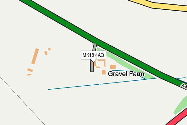
MK18 4AQ lies on Banbury Road in Finmere, Buckingham. MK18 4AQ is located in the Fringford and Heyfords electoral ward, within the local authority district of Cherwell and the English Parliamentary constituency of Banbury. The Sub Integrated Care Board (ICB) Location is NHS Buckinghamshire, Oxfordshire and Berkshire West ICB - 10Q and the police force is Thames Valley. This postcode has been in use since January 1980.


GetTheData
Source: OS OpenMap – Local (Ordnance Survey)
Source: OS VectorMap District (Ordnance Survey)
Licence: Open Government Licence (requires attribution)
| Easting | 463541 |
| Northing | 232521 |
| Latitude | 51.987519 |
| Longitude | -1.076113 |
GetTheData
Source: Open Postcode Geo
Licence: Open Government Licence
| Street | Banbury Road |
| Locality | Finmere |
| Town/City | Buckingham |
| Country | England |
| Postcode District | MK18 |
| ➜ MK18 open data dashboard ➜ See where MK18 is on a map | |
GetTheData
Source: Land Registry Price Paid Data
Licence: Open Government Licence
Elevation or altitude of MK18 4AQ as distance above sea level:
| Metres | Feet | |
|---|---|---|
| Elevation | 120m | 394ft |
Elevation is measured from the approximate centre of the postcode, to the nearest point on an OS contour line from OS Terrain 50, which has contour spacing of ten vertical metres.
➜ How high above sea level am I? Find the elevation of your current position using your device's GPS.
GetTheData
Source: Open Postcode Elevation
Licence: Open Government Licence
| Ward | Fringford And Heyfords |
| Constituency | Banbury |
GetTheData
Source: ONS Postcode Database
Licence: Open Government Licence
| March 2022 | Public order | On or near Valley Road | 447m |
| October 2021 | Other crime | On or near Chinalls Close | 403m |
| August 2021 | Criminal damage and arson | On or near Ushercombe View | 356m |
| ➜ Get more crime data in our Crime section | |||
GetTheData
Source: data.police.uk
Licence: Open Government Licence
| Crossroads Kings Head (Valley Road) | Finmere | 413m |
| Crossroads Kings Head (Valley Road) | Finmere | 465m |
| The Red Lion Ph (Sandpit Hill) | Little Tingewick | 551m |
| The Red Lion Ph (Sandpit Hill) | Little Tingewick | 594m |
| Shelswell Inn Ph (A4421) | Newton Purcell | 1,593m |
GetTheData
Source: NaPTAN
Licence: Open Government Licence
| Percentage of properties with Next Generation Access | 100.0% |
| Percentage of properties with Superfast Broadband | 100.0% |
| Percentage of properties with Ultrafast Broadband | 0.0% |
| Percentage of properties with Full Fibre Broadband | 0.0% |
Superfast Broadband is between 30Mbps and 300Mbps
Ultrafast Broadband is > 300Mbps
| Percentage of properties unable to receive 2Mbps | 0.0% |
| Percentage of properties unable to receive 5Mbps | 0.0% |
| Percentage of properties unable to receive 10Mbps | 0.0% |
| Percentage of properties unable to receive 30Mbps | 0.0% |
GetTheData
Source: Ofcom
Licence: Ofcom Terms of Use (requires attribution)
GetTheData
Source: ONS Postcode Database
Licence: Open Government Licence

➜ Get more ratings from the Food Standards Agency
GetTheData
Source: Food Standards Agency
Licence: FSA terms & conditions
| Last Collection | |||
|---|---|---|---|
| Location | Mon-Fri | Sat | Distance |
| Camstone Main Street | 16:45 | 09:30 | 489m |
| Finmere | 16:40 | 09:40 | 510m |
| Newton Purcell | 16:30 | 09:00 | 1,598m |
GetTheData
Source: Dracos
Licence: Creative Commons Attribution-ShareAlike
| Facility | Distance |
|---|---|
| Finmere Playing Fields Water Stratford Road, Finmere Grass Pitches | 693m |
| Tingewick Recreation Ground Water Stratford Road, Tingewick, Buckingham Grass Pitches | 1.7km |
| Beachborough School Westbury, Brackley Sports Hall, Artificial Grass Pitch, Grass Pitches | 3.5km |
GetTheData
Source: Active Places
Licence: Open Government Licence
| School | Phase of Education | Distance |
|---|---|---|
| Finmere Church of England Primary School Mere Road, Finmere, Buckingham, MK18 4AR | Primary | 310m |
| Beachborough School Westbury, Brackley, NN13 5LB | Not applicable | 3.5km |
| Roundwood Primary School Church Street, Gawcott, Buckingham, MK18 4HY | Primary | 4.6km |
GetTheData
Source: Edubase
Licence: Open Government Licence
The below table lists the International Territorial Level (ITL) codes (formerly Nomenclature of Territorial Units for Statistics (NUTS) codes) and Local Administrative Units (LAU) codes for MK18 4AQ:
| ITL 1 Code | Name |
|---|---|
| TLJ | South East (England) |
| ITL 2 Code | Name |
| TLJ1 | Berkshire, Buckinghamshire and Oxfordshire |
| ITL 3 Code | Name |
| TLJ14 | Oxfordshire CC |
| LAU 1 Code | Name |
| E07000177 | Cherwell |
GetTheData
Source: ONS Postcode Directory
Licence: Open Government Licence
The below table lists the Census Output Area (OA), Lower Layer Super Output Area (LSOA), and Middle Layer Super Output Area (MSOA) for MK18 4AQ:
| Code | Name | |
|---|---|---|
| OA | E00145131 | |
| LSOA | E01028483 | Cherwell 011D |
| MSOA | E02005931 | Cherwell 011 |
GetTheData
Source: ONS Postcode Directory
Licence: Open Government Licence
| MK18 4BE | Banbury Road | 249m |
| MK18 4BW | Banbury Road | 291m |
| MK18 4AL | Valley Road | 350m |
| MK18 4AP | Town Close | 387m |
| MK18 4AR | Mere Road | 391m |
| MK18 4BQ | Chinalls Close | 394m |
| MK18 4AN | Banbury Road | 404m |
| MK18 4BG | Valley Road | 437m |
| MK18 4AW | Mere Road | 450m |
| MK18 4AD | Stable Close | 498m |
GetTheData
Source: Open Postcode Geo; Land Registry Price Paid Data
Licence: Open Government Licence