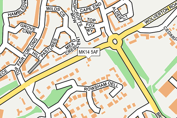
MK14 5AF is located in the Newport Pagnell South electoral ward, within the unitary authority of Milton Keynes and the English Parliamentary constituency of Milton Keynes North. The Sub Integrated Care Board (ICB) Location is NHS Bedfordshire, Luton and Milton Keynes ICB - M1J4Y and the police force is Thames Valley. This postcode has been in use since January 1980.


GetTheData
Source: OS OpenMap – Local (Ordnance Survey)
Source: OS VectorMap District (Ordnance Survey)
Licence: Open Government Licence (requires attribution)
| Easting | 485773 |
| Northing | 242982 |
| Latitude | 52.078564 |
| Longitude | -0.749819 |
GetTheData
Source: Open Postcode Geo
Licence: Open Government Licence
| Country | England |
| Postcode District | MK14 |
| ➜ MK14 open data dashboard ➜ See where MK14 is on a map | |
GetTheData
Source: Land Registry Price Paid Data
Licence: Open Government Licence
Elevation or altitude of MK14 5AF as distance above sea level:
| Metres | Feet | |
|---|---|---|
| Elevation | 70m | 230ft |
Elevation is measured from the approximate centre of the postcode, to the nearest point on an OS contour line from OS Terrain 50, which has contour spacing of ten vertical metres.
➜ How high above sea level am I? Find the elevation of your current position using your device's GPS.
GetTheData
Source: Open Postcode Elevation
Licence: Open Government Licence
| Ward | Newport Pagnell South |
| Constituency | Milton Keynes North |
GetTheData
Source: ONS Postcode Database
Licence: Open Government Licence
| January 2024 | Violence and sexual offences | On or near Hopcrofts Meadow | 116m |
| January 2024 | Violence and sexual offences | On or near Hopcrofts Meadow | 116m |
| January 2024 | Criminal damage and arson | On or near Petrol Station | 452m |
| ➜ Get more crime data in our Crime section | |||
GetTheData
Source: data.police.uk
Licence: Open Government Licence
| Horton Gate (Brickhill Street V10) | Giffard Park | 176m |
| Giffard Park Roundabout East (Wolverton Road) | Giffard Park | 177m |
| Giffard Park Roundabout East (Wolverton Road) | Giffard Park | 182m |
| Horton Gate (Brickhill Street V10) | Giffard Park | 193m |
| Top Fair Furlong | Redhouse Park | 245m |
| Wolverton Station | 4km |
| Milton Keynes Central Station | 5.2km |
GetTheData
Source: NaPTAN
Licence: Open Government Licence
| Percentage of properties with Next Generation Access | 100.0% |
| Percentage of properties with Superfast Broadband | 0.0% |
| Percentage of properties with Ultrafast Broadband | 0.0% |
| Percentage of properties with Full Fibre Broadband | 0.0% |
Superfast Broadband is between 30Mbps and 300Mbps
Ultrafast Broadband is > 300Mbps
| Percentage of properties unable to receive 2Mbps | 0.0% |
| Percentage of properties unable to receive 5Mbps | 0.0% |
| Percentage of properties unable to receive 10Mbps | 0.0% |
| Percentage of properties unable to receive 30Mbps | 100.0% |
GetTheData
Source: Ofcom
Licence: Ofcom Terms of Use (requires attribution)
GetTheData
Source: ONS Postcode Database
Licence: Open Government Licence


➜ Get more ratings from the Food Standards Agency
GetTheData
Source: Food Standards Agency
Licence: FSA terms & conditions
| Last Collection | |||
|---|---|---|---|
| Location | Mon-Fri | Sat | Distance |
| Station Terrace | 16:30 | 12:00 | 363m |
| Tanners Drive | 18:30 | 378m | |
| Tanners Drive | 18:30 | 12:00 | 467m |
GetTheData
Source: Dracos
Licence: Creative Commons Attribution-ShareAlike
| Facility | Distance |
|---|---|
| Giffard Park Primary School Broadway Avenue, Giffard Park, Milton Keynes Grass Pitches | 617m |
| Marsh Drive Sports Ground Marsh Drive, Great Linford, Milton Keynes Grass Pitches, Outdoor Tennis Courts | 884m |
| Great Linford Cricket Pavilion High Street, Great Linford, Milton Keynes Grass Pitches | 987m |
GetTheData
Source: Active Places
Licence: Open Government Licence
| School | Phase of Education | Distance |
|---|---|---|
| Giffard Park Primary School Broadway Avenue, Giffard Park, Giffard Park Primary School, Milton Keynes, MK14 5PY | Primary | 617m |
| Ousedale School The Grove, Newport Pagnell, MK16 0BJ | Secondary | 1km |
| Portfields Primary School Westbury Lane, Newport Pagnell, MK16 8PS | Primary | 1.1km |
GetTheData
Source: Edubase
Licence: Open Government Licence
The below table lists the International Territorial Level (ITL) codes (formerly Nomenclature of Territorial Units for Statistics (NUTS) codes) and Local Administrative Units (LAU) codes for MK14 5AF:
| ITL 1 Code | Name |
|---|---|
| TLJ | South East (England) |
| ITL 2 Code | Name |
| TLJ1 | Berkshire, Buckinghamshire and Oxfordshire |
| ITL 3 Code | Name |
| TLJ12 | Milton Keynes |
| LAU 1 Code | Name |
| E06000042 | Milton Keynes |
GetTheData
Source: ONS Postcode Directory
Licence: Open Government Licence
The below table lists the Census Output Area (OA), Lower Layer Super Output Area (LSOA), and Middle Layer Super Output Area (MSOA) for MK14 5AF:
| Code | Name | |
|---|---|---|
| OA | E00084591 | |
| LSOA | E01016767 | Milton Keynes 005D |
| MSOA | E02003463 | Milton Keynes 005 |
GetTheData
Source: ONS Postcode Directory
Licence: Open Government Licence
| MK14 5FX | Mead Crescent | 94m |
| MK14 5BY | Hopcrofts Meadow | 99m |
| MK14 5FF | Lime Kiln Way | 109m |
| MK14 5JS | Rowsham Dell | 123m |
| MK14 5FG | Top Fox Way | 128m |
| MK14 5FW | Hill Pastures | 130m |
| MK14 5FE | Cape End | 158m |
| MK14 5FT | Top Fair Furlong | 175m |
| MK14 5FY | Wilds Cross | 177m |
| MK14 5FL | Alder Court | 183m |
GetTheData
Source: Open Postcode Geo; Land Registry Price Paid Data
Licence: Open Government Licence