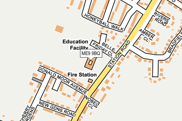
ME9 9BQ is located in the Teynham and Lynsted electoral ward, within the local authority district of Swale and the English Parliamentary constituency of Sittingbourne and Sheppey. The Sub Integrated Care Board (ICB) Location is NHS Kent and Medway ICB - 91Q and the police force is Kent. This postcode has been in use since December 1996.


GetTheData
Source: OS OpenMap – Local (Ordnance Survey)
Source: OS VectorMap District (Ordnance Survey)
Licence: Open Government Licence (requires attribution)
| Easting | 595413 |
| Northing | 162724 |
| Latitude | 51.330029 |
| Longitude | 0.803588 |
GetTheData
Source: Open Postcode Geo
Licence: Open Government Licence
| Country | England |
| Postcode District | ME9 |
| ➜ ME9 open data dashboard ➜ See where ME9 is on a map ➜ Where is Teynham? | |
GetTheData
Source: Land Registry Price Paid Data
Licence: Open Government Licence
Elevation or altitude of ME9 9BQ as distance above sea level:
| Metres | Feet | |
|---|---|---|
| Elevation | 20m | 66ft |
Elevation is measured from the approximate centre of the postcode, to the nearest point on an OS contour line from OS Terrain 50, which has contour spacing of ten vertical metres.
➜ How high above sea level am I? Find the elevation of your current position using your device's GPS.
GetTheData
Source: Open Postcode Elevation
Licence: Open Government Licence
| Ward | Teynham And Lynsted |
| Constituency | Sittingbourne And Sheppey |
GetTheData
Source: ONS Postcode Database
Licence: Open Government Licence
| July 2023 | Violence and sexual offences | On or near Bradfield Avenue | 287m |
| July 2023 | Criminal damage and arson | On or near Bradfield Avenue | 287m |
| June 2022 | Public order | On or near Station Road | 92m |
| ➜ Get more crime data in our Crime section | |||
GetTheData
Source: data.police.uk
Licence: Open Government Licence
| Honeyball Walk (Station Road) | Teynham | 169m |
| Honeyball Walk (Station Road) | Teynham | 191m |
| Frognal Gardens (Station Road) | Teynham | 219m |
| Frognal Gardens (Station Road) | Teynham | 240m |
| Dover Castle (London Road) | Teynham | 315m |
| Teynham Station | 0.5km |
| Sittingbourne Station | 5km |
| Kemsley Station | 6km |
GetTheData
Source: NaPTAN
Licence: Open Government Licence
GetTheData
Source: ONS Postcode Database
Licence: Open Government Licence


➜ Get more ratings from the Food Standards Agency
GetTheData
Source: Food Standards Agency
Licence: FSA terms & conditions
| Last Collection | |||
|---|---|---|---|
| Location | Mon-Fri | Sat | Distance |
| Teynham Post Office | 16:30 | 09:00 | 349m |
| Station Road | 17:15 | 09:00 | 433m |
| Cellar Hill | 17:00 | 09:00 | 449m |
GetTheData
Source: Dracos
Licence: Creative Commons Attribution-ShareAlike
| Facility | Distance |
|---|---|
| Frognal Playing Field Frognal Lane, Teynham, Sittingbourne Grass Pitches | 502m |
| Isp Teynham Conyer Road , Teynham, Sittingbourne Grass Pitches | 750m |
| Bapchild Cricket Club London Road, Bapchild, Sittingbourne Grass Pitches | 1.7km |
GetTheData
Source: Active Places
Licence: Open Government Licence
| School | Phase of Education | Distance |
|---|---|---|
| Teynham Parochial Church of England Primary School Station Road, Teynham, Sittingbourne, ME9 9BQ | Primary | 12m |
| Alchemy School 72 Station Road, Teynham, Kent, ME9 9SN | Not applicable | 107m |
| ISP School Castlewood Farm, Conyer Road, Teynham, Kent, ME9 9EA | Not applicable | 733m |
GetTheData
Source: Edubase
Licence: Open Government Licence
The below table lists the International Territorial Level (ITL) codes (formerly Nomenclature of Territorial Units for Statistics (NUTS) codes) and Local Administrative Units (LAU) codes for ME9 9BQ:
| ITL 1 Code | Name |
|---|---|
| TLJ | South East (England) |
| ITL 2 Code | Name |
| TLJ4 | Kent |
| ITL 3 Code | Name |
| TLJ43 | Kent Thames Gateway |
| LAU 1 Code | Name |
| E07000113 | Swale |
GetTheData
Source: ONS Postcode Directory
Licence: Open Government Licence
The below table lists the Census Output Area (OA), Lower Layer Super Output Area (LSOA), and Middle Layer Super Output Area (MSOA) for ME9 9BQ:
| Code | Name | |
|---|---|---|
| OA | E00124968 | |
| LSOA | E01024623 | Swale 016D |
| MSOA | E02005130 | Swale 016 |
GetTheData
Source: ONS Postcode Directory
Licence: Open Government Licence
| ME9 9TU | Belle Friday Close | 63m |
| ME9 9SN | Station Road | 84m |
| ME9 9TX | Morello Close | 110m |
| ME9 9SJ | Donald Moor Avenue | 122m |
| ME9 9SY | Nobel Close | 128m |
| ME9 9SQ | Station Road | 143m |
| ME9 9TJ | Station Road | 156m |
| ME9 9SL | Donald Moor Avenue | 157m |
| ME9 9SG | Newgardens Road | 181m |
| ME9 9TN | Honeyball Walk | 183m |
GetTheData
Source: Open Postcode Geo; Land Registry Price Paid Data
Licence: Open Government Licence