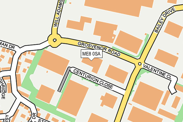
ME8 0SA is located in the Watling electoral ward, within the unitary authority of Medway and the English Parliamentary constituency of Gillingham and Rainham. The Sub Integrated Care Board (ICB) Location is NHS Kent and Medway ICB - 91Q and the police force is Kent. This postcode has been in use since February 1990.


GetTheData
Source: OS OpenMap – Local (Ordnance Survey)
Source: OS VectorMap District (Ordnance Survey)
Licence: Open Government Licence (requires attribution)
| Easting | 578877 |
| Northing | 166239 |
| Latitude | 51.367041 |
| Longitude | 0.568291 |
GetTheData
Source: Open Postcode Geo
Licence: Open Government Licence
| Country | England |
| Postcode District | ME8 |
| ➜ ME8 open data dashboard ➜ See where ME8 is on a map ➜ Where is Gillingham? | |
GetTheData
Source: Land Registry Price Paid Data
Licence: Open Government Licence
Elevation or altitude of ME8 0SA as distance above sea level:
| Metres | Feet | |
|---|---|---|
| Elevation | 90m | 295ft |
Elevation is measured from the approximate centre of the postcode, to the nearest point on an OS contour line from OS Terrain 50, which has contour spacing of ten vertical metres.
➜ How high above sea level am I? Find the elevation of your current position using your device's GPS.
GetTheData
Source: Open Postcode Elevation
Licence: Open Government Licence
| Ward | Watling |
| Constituency | Gillingham And Rainham |
GetTheData
Source: ONS Postcode Database
Licence: Open Government Licence
| May 2023 | Criminal damage and arson | On or near Heritage Drive | 235m |
| April 2023 | Vehicle crime | On or near Heritage Drive | 235m |
| March 2023 | Criminal damage and arson | On or near Heritage Drive | 235m |
| ➜ Get more crime data in our Crime section | |||
GetTheData
Source: data.police.uk
Licence: Open Government Licence
| Hamelin Road (Darland Avenue) | Darland | 354m |
| Hamelin Road (Darland Avenue) | Darland | 364m |
| Leyton Avenue (Darland Avenue) | Darland | 448m |
| Featherby Road South (Watling Street) | Gillingham | 463m |
| Leyton Avenue (Darland Avenue) | Darland | 478m |
| Gillingham (Kent) Station | 2.5km |
| Rainham (Kent) Station | 3km |
| Chatham Station | 3.6km |
GetTheData
Source: NaPTAN
Licence: Open Government Licence
GetTheData
Source: ONS Postcode Database
Licence: Open Government Licence


➜ Get more ratings from the Food Standards Agency
GetTheData
Source: Food Standards Agency
Licence: FSA terms & conditions
| Last Collection | |||
|---|---|---|---|
| Location | Mon-Fri | Sat | Distance |
| Yeoman Drive | 17:45 | 12:15 | 115m |
| Hamelin Road | 17:15 | 11:30 | 364m |
| Bailey Drive Meter Box | 18:30 | 12:00 | 462m |
GetTheData
Source: Dracos
Licence: Creative Commons Attribution-ShareAlike
| Facility | Distance |
|---|---|
| Gillingham Anchorians Sports Club Darland Avenue, Darland, Gillingham Artificial Grass Pitch | 301m |
| Watling Street Watling Street, Gillingham Grass Pitches | 354m |
| Watling Park Football Centre Darland Avenue, Gillingham Artificial Grass Pitch | 378m |
GetTheData
Source: Active Places
Licence: Open Government Licence
| School | Phase of Education | Distance |
|---|---|---|
| Danecourt School Hotel Road, Gillingham, ME8 6AA | Not applicable | 498m |
| Featherby Junior School Chilham Road, Featherby Junior School, Gillingham, ME8 6BT | Primary | 1km |
| St Thomas of Canterbury RC Primary School Romany Road, Rainham, Gillingham, ME8 6JH | Primary | 1.1km |
GetTheData
Source: Edubase
Licence: Open Government Licence
The below table lists the International Territorial Level (ITL) codes (formerly Nomenclature of Territorial Units for Statistics (NUTS) codes) and Local Administrative Units (LAU) codes for ME8 0SA:
| ITL 1 Code | Name |
|---|---|
| TLJ | South East (England) |
| ITL 2 Code | Name |
| TLJ4 | Kent |
| ITL 3 Code | Name |
| TLJ41 | Medway |
| LAU 1 Code | Name |
| E06000035 | Medway |
GetTheData
Source: ONS Postcode Directory
Licence: Open Government Licence
The below table lists the Census Output Area (OA), Lower Layer Super Output Area (LSOA), and Middle Layer Super Output Area (MSOA) for ME8 0SA:
| Code | Name | |
|---|---|---|
| OA | E00081747 | |
| LSOA | E01016176 | Medway 030D |
| MSOA | E02003343 | Medway 030 |
GetTheData
Source: ONS Postcode Directory
Licence: Open Government Licence
| ME7 3EG | Academy Drive | 141m |
| ME7 3EW | Highridge | 192m |
| ME7 3AG | Stoney Bank | 214m |
| ME7 3EL | Yeoman Drive | 219m |
| ME7 3EH | Heritage Drive | 224m |
| ME7 3EJ | Academy Drive | 257m |
| ME7 3EN | Embassy Close | 261m |
| ME7 3EQ | Heritage Drive | 264m |
| ME7 3AH | Darland Avenue | 289m |
| ME7 3AS | Darland Avenue | 341m |
GetTheData
Source: Open Postcode Geo; Land Registry Price Paid Data
Licence: Open Government Licence