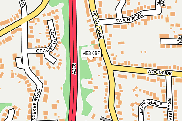
ME8 0BF is located in the Rainham South West electoral ward, within the unitary authority of Medway and the English Parliamentary constituency of Gillingham and Rainham. The Sub Integrated Care Board (ICB) Location is NHS Kent and Medway ICB - 91Q and the police force is Kent. This postcode has been in use since November 2008.


GetTheData
Source: OS OpenMap – Local (Ordnance Survey)
Source: OS VectorMap District (Ordnance Survey)
Licence: Open Government Licence (requires attribution)
| Easting | 579720 |
| Northing | 164745 |
| Latitude | 51.353355 |
| Longitude | 0.579604 |
GetTheData
Source: Open Postcode Geo
Licence: Open Government Licence
| Country | England |
| Postcode District | ME8 |
| ➜ ME8 open data dashboard ➜ See where ME8 is on a map ➜ Where is Gillingham? | |
GetTheData
Source: Land Registry Price Paid Data
Licence: Open Government Licence
Elevation or altitude of ME8 0BF as distance above sea level:
| Metres | Feet | |
|---|---|---|
| Elevation | 100m | 328ft |
Elevation is measured from the approximate centre of the postcode, to the nearest point on an OS contour line from OS Terrain 50, which has contour spacing of ten vertical metres.
➜ How high above sea level am I? Find the elevation of your current position using your device's GPS.
GetTheData
Source: Open Postcode Elevation
Licence: Open Government Licence
| Ward | Rainham South West |
| Constituency | Gillingham And Rainham |
GetTheData
Source: ONS Postcode Database
Licence: Open Government Licence
| June 2022 | Violence and sexual offences | On or near Grassy Glade | 173m |
| June 2022 | Vehicle crime | On or near Swain Road | 194m |
| June 2022 | Violence and sexual offences | On or near The Wheelers | 202m |
| ➜ Get more crime data in our Crime section | |||
GetTheData
Source: data.police.uk
Licence: Open Government Licence
| Spyglass And Kettle (Woodside) | Wigmore | 118m |
| Spyglass And Kettle (Woodside) | Wigmore | 145m |
| Tanglewood Close (Bredhurst Road) | Wigmore | 338m |
| Smallholders Club (Springvale) | Wigmore | 353m |
| Smallholders Club (Springvale) | Wigmore | 364m |
| Rainham (Kent) Station | 2.6km |
| Gillingham (Kent) Station | 4.2km |
| Chatham Station | 5.1km |
GetTheData
Source: NaPTAN
Licence: Open Government Licence
GetTheData
Source: ONS Postcode Database
Licence: Open Government Licence


➜ Get more ratings from the Food Standards Agency
GetTheData
Source: Food Standards Agency
Licence: FSA terms & conditions
| Last Collection | |||
|---|---|---|---|
| Location | Mon-Fri | Sat | Distance |
| Wigmore Road | 17:30 | 12:15 | 290m |
| Wigmore Post Office | 17:30 | 12:00 | 429m |
| Hempstead | 17:30 | 12:00 | 638m |
GetTheData
Source: Dracos
Licence: Creative Commons Attribution-ShareAlike
| Facility | Distance |
|---|---|
| Hempstead Recreation Ground Hempstead Road, Hempstead, Gillingham Grass Pitches | 608m |
| Fairview School Drewery Drive, Gillingham Grass Pitches | 765m |
| Hempstead Infant School Hempstead Road, Hempstead Road, Hempstead, Gillingham Grass Pitches | 812m |
GetTheData
Source: Active Places
Licence: Open Government Licence
| School | Phase of Education | Distance |
|---|---|---|
| Bryony School 157 Marshall Road, Rainham, Marshall Road, Rainham, ME8 0AJ | Not applicable | 697m |
| Fairview Community Primary School Drewery Drive, Wigmore, Gillingham, ME8 0NU | Primary | 786m |
| Hempstead Infant School Hempstead Road, Hempstead, Gillingham, ME7 3QG | Primary | 813m |
GetTheData
Source: Edubase
Licence: Open Government Licence
The below table lists the International Territorial Level (ITL) codes (formerly Nomenclature of Territorial Units for Statistics (NUTS) codes) and Local Administrative Units (LAU) codes for ME8 0BF:
| ITL 1 Code | Name |
|---|---|
| TLJ | South East (England) |
| ITL 2 Code | Name |
| TLJ4 | Kent |
| ITL 3 Code | Name |
| TLJ41 | Medway |
| LAU 1 Code | Name |
| E06000035 | Medway |
GetTheData
Source: ONS Postcode Directory
Licence: Open Government Licence
The below table lists the Census Output Area (OA), Lower Layer Super Output Area (LSOA), and Middle Layer Super Output Area (MSOA) for ME8 0BF:
| Code | Name | |
|---|---|---|
| OA | E00081337 | |
| LSOA | E01016085 | Medway 030A |
| MSOA | E02003343 | Medway 030 |
GetTheData
Source: ONS Postcode Directory
Licence: Open Government Licence
| ME8 0SW | Hoath Lane | 72m |
| ME8 0SP | Wigmore Road | 143m |
| ME8 0PG | Woodside | 144m |
| ME7 3RR | Grassy Glade | 150m |
| ME8 0SL | Hoath Lane | 180m |
| ME7 3RS | Spekes Road | 189m |
| ME8 0PJ | Leafy Glade | 209m |
| ME7 3SA | Hempstead Road | 216m |
| ME8 0SN | Swain Road | 216m |
| ME8 0PQ | Woodside | 219m |
GetTheData
Source: Open Postcode Geo; Land Registry Price Paid Data
Licence: Open Government Licence