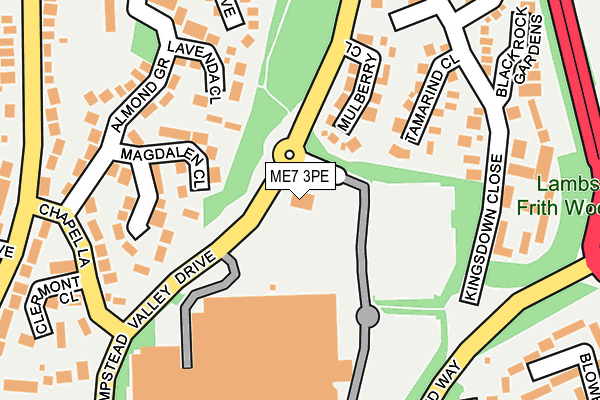
ME7 3PE is located in the Hempstead & Wigmore electoral ward, within the unitary authority of Medway and the English Parliamentary constituency of Gillingham and Rainham. The Sub Integrated Care Board (ICB) Location is NHS Kent and Medway ICB - 91Q and the police force is Kent. This postcode has been in use since March 1983.


GetTheData
Source: OS OpenMap – Local (Ordnance Survey)
Source: OS VectorMap District (Ordnance Survey)
Licence: Open Government Licence (requires attribution)
| Easting | 579339 |
| Northing | 163606 |
| Latitude | 51.343244 |
| Longitude | 0.573565 |
GetTheData
Source: Open Postcode Geo
Licence: Open Government Licence
| Country | England |
| Postcode District | ME7 |
| ➜ ME7 open data dashboard ➜ See where ME7 is on a map ➜ Where is Gillingham? | |
GetTheData
Source: Land Registry Price Paid Data
Licence: Open Government Licence
Elevation or altitude of ME7 3PE as distance above sea level:
| Metres | Feet | |
|---|---|---|
| Elevation | 100m | 328ft |
Elevation is measured from the approximate centre of the postcode, to the nearest point on an OS contour line from OS Terrain 50, which has contour spacing of ten vertical metres.
➜ How high above sea level am I? Find the elevation of your current position using your device's GPS.
GetTheData
Source: Open Postcode Elevation
Licence: Open Government Licence
| Ward | Hempstead & Wigmore |
| Constituency | Gillingham And Rainham |
GetTheData
Source: ONS Postcode Database
Licence: Open Government Licence
| January 2024 | Anti-social behaviour | On or near Barncroft Drive | 344m |
| January 2024 | Criminal damage and arson | On or near Barncroft Drive | 344m |
| December 2023 | Violence and sexual offences | On or near Barncroft Drive | 344m |
| ➜ Get more crime data in our Crime section | |||
GetTheData
Source: data.police.uk
Licence: Open Government Licence
| Kingsdown Close (Hempstead Valley Drive) | Hempstead | 198m |
| Hempstead Valley Shopping Centre | Hempstead | 294m |
| Hempstead Valley Shopping Centre | Hempstead | 305m |
| Hempstead Road | Hempstead | 308m |
| Kingsdown Close (Hempstead Valley Drive) | Hempstead | 328m |
| Rainham (Kent) Station | 3.7km |
| Gillingham (Kent) Station | 5.1km |
| Chatham Station | 5.5km |
GetTheData
Source: NaPTAN
Licence: Open Government Licence
GetTheData
Source: ONS Postcode Database
Licence: Open Government Licence


➜ Get more ratings from the Food Standards Agency
GetTheData
Source: Food Standards Agency
Licence: FSA terms & conditions
| Last Collection | |||
|---|---|---|---|
| Location | Mon-Fri | Sat | Distance |
| Hempstead Valley | 18:30 | 12:00 | 194m |
| Lambsfrith Grove | 17:30 | 12:15 | 440m |
| Grain Road | 17:30 | 12:00 | 671m |
GetTheData
Source: Dracos
Licence: Creative Commons Attribution-ShareAlike
| Facility | Distance |
|---|---|
| Jd Gyms (Hempstead Valley) Hempstead Valley Shopping Centre, Hempstead, Gillingham Health and Fitness Gym | 322m |
| Hempstead Junior School Birch Grove, Hempstead, Gillingham Grass Pitches | 419m |
| Kings Frith Wigmore Road, Gillingham Grass Pitches | 573m |
GetTheData
Source: Active Places
Licence: Open Government Licence
| School | Phase of Education | Distance |
|---|---|---|
| Hempstead Junior School Birch Grove, Hempstead, Gillingham, ME7 3HJ | Primary | 431m |
| Hempstead Infant School Hempstead Road, Hempstead, Gillingham, ME7 3QG | Primary | 577m |
| Fairview Community Primary School Drewery Drive, Wigmore, Gillingham, ME8 0NU | Primary | 1.1km |
GetTheData
Source: Edubase
Licence: Open Government Licence
The below table lists the International Territorial Level (ITL) codes (formerly Nomenclature of Territorial Units for Statistics (NUTS) codes) and Local Administrative Units (LAU) codes for ME7 3PE:
| ITL 1 Code | Name |
|---|---|
| TLJ | South East (England) |
| ITL 2 Code | Name |
| TLJ4 | Kent |
| ITL 3 Code | Name |
| TLJ41 | Medway |
| LAU 1 Code | Name |
| E06000035 | Medway |
GetTheData
Source: ONS Postcode Directory
Licence: Open Government Licence
The below table lists the Census Output Area (OA), Lower Layer Super Output Area (LSOA), and Middle Layer Super Output Area (MSOA) for ME7 3PE:
| Code | Name | |
|---|---|---|
| OA | E00081144 | |
| LSOA | E01016052 | Medway 035C |
| MSOA | E02003348 | Medway 035 |
GetTheData
Source: ONS Postcode Directory
Licence: Open Government Licence
| ME7 3SJ | Mulberry Close | 125m |
| ME7 3TA | Magdalen Close | 140m |
| ME7 3ST | Tamarind Close | 160m |
| ME7 3TB | Lavenda Close | 172m |
| ME7 3PB | Hempstead Valley Shopping Centre | 183m |
| ME7 3PX | Kingsdown Close | 197m |
| ME7 3TD | Chapel Lane | 206m |
| ME7 3SE | Almond Grove | 212m |
| ME7 3SY | Thistledown Close | 229m |
| ME7 3TE | Kingsdown Close | 230m |
GetTheData
Source: Open Postcode Geo; Land Registry Price Paid Data
Licence: Open Government Licence