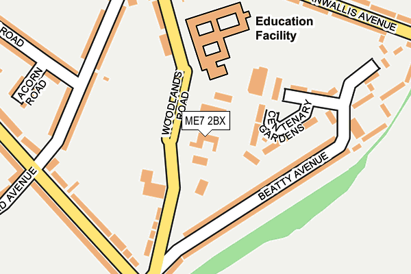
ME7 2BX is located in the Watling electoral ward, within the unitary authority of Medway and the English Parliamentary constituency of Gillingham and Rainham. The Sub Integrated Care Board (ICB) Location is NHS Kent and Medway ICB - 91Q and the police force is Kent. This postcode has been in use since January 1980.


GetTheData
Source: OS OpenMap – Local (Ordnance Survey)
Source: OS VectorMap District (Ordnance Survey)
Licence: Open Government Licence (requires attribution)
| Easting | 578795 |
| Northing | 167631 |
| Latitude | 51.379571 |
| Longitude | 0.567785 |
GetTheData
Source: Open Postcode Geo
Licence: Open Government Licence
| Country | England |
| Postcode District | ME7 |
| ➜ ME7 open data dashboard ➜ See where ME7 is on a map ➜ Where is Gillingham? | |
GetTheData
Source: Land Registry Price Paid Data
Licence: Open Government Licence
Elevation or altitude of ME7 2BX as distance above sea level:
| Metres | Feet | |
|---|---|---|
| Elevation | 50m | 164ft |
Elevation is measured from the approximate centre of the postcode, to the nearest point on an OS contour line from OS Terrain 50, which has contour spacing of ten vertical metres.
➜ How high above sea level am I? Find the elevation of your current position using your device's GPS.
GetTheData
Source: Open Postcode Elevation
Licence: Open Government Licence
| Ward | Watling |
| Constituency | Gillingham And Rainham |
GetTheData
Source: ONS Postcode Database
Licence: Open Government Licence
| June 2022 | Vehicle crime | On or near Sports/Recreation Area | 119m |
| June 2022 | Other crime | On or near Sports/Recreation Area | 119m |
| June 2022 | Violence and sexual offences | On or near Beatty Avenue | 126m |
| ➜ Get more crime data in our Crime section | |||
GetTheData
Source: data.police.uk
Licence: Open Government Licence
| Woodlands Family Practice (Woodlands Road) | Gillingham | 70m |
| Woodlands Primary School (Woodlands Road) | Gillingham | 178m |
| Beatty Avenue (Woodlands Road) | Gillingham | 189m |
| Beatty Avenue (Sturdee Avenue) | Gillingham | 231m |
| Third Avenue East (Sturdee Avenue) | Gillingham | 249m |
| Gillingham (Kent) Station | 1.5km |
| Chatham Station | 3.2km |
| Rainham (Kent) Station | 3.4km |
GetTheData
Source: NaPTAN
Licence: Open Government Licence
GetTheData
Source: ONS Postcode Database
Licence: Open Government Licence


➜ Get more ratings from the Food Standards Agency
GetTheData
Source: Food Standards Agency
Licence: FSA terms & conditions
| Last Collection | |||
|---|---|---|---|
| Location | Mon-Fri | Sat | Distance |
| Sturdee Avenue Post Office | 17:30 | 11:30 | 353m |
| First Avenue | 17:45 | 11:45 | 404m |
| Harold Avenue | 17:30 | 11:30 | 560m |
GetTheData
Source: Dracos
Licence: Creative Commons Attribution-ShareAlike
| Facility | Distance |
|---|---|
| Rookery Fields Woodlands Road, Woodlands Road, Gillingham Grass Pitches | 80m |
| Woodlands Sport Centre Woodlands Road, Gillingham Health and Fitness Gym, Sports Hall, Artificial Grass Pitch | 145m |
| Esabs Field Cornwallis Avenue, Gillingham Grass Pitches | 499m |
GetTheData
Source: Active Places
Licence: Open Government Licence
| School | Phase of Education | Distance |
|---|---|---|
| Will Adams Academy Woodlands Road, Gillingham, ME7 2BX | Not applicable | 22m |
| The Academy of Woodlands Woodlands Road, Gillingham, ME7 2DU | Primary | 187m |
| The Robert Napier School Third Avenue, Gillingham, ME7 2LX | Secondary | 516m |
GetTheData
Source: Edubase
Licence: Open Government Licence
The below table lists the International Territorial Level (ITL) codes (formerly Nomenclature of Territorial Units for Statistics (NUTS) codes) and Local Administrative Units (LAU) codes for ME7 2BX:
| ITL 1 Code | Name |
|---|---|
| TLJ | South East (England) |
| ITL 2 Code | Name |
| TLJ4 | Kent |
| ITL 3 Code | Name |
| TLJ41 | Medway |
| LAU 1 Code | Name |
| E06000035 | Medway |
GetTheData
Source: ONS Postcode Directory
Licence: Open Government Licence
The below table lists the Census Output Area (OA), Lower Layer Super Output Area (LSOA), and Middle Layer Super Output Area (MSOA) for ME7 2BX:
| Code | Name | |
|---|---|---|
| OA | E00081682 | |
| LSOA | E01016159 | Medway 019A |
| MSOA | E02003332 | Medway 019 |
GetTheData
Source: ONS Postcode Directory
Licence: Open Government Licence
| ME7 2BZ | Beatty Avenue | 138m |
| ME7 2BU | Woodlands Road | 151m |
| ME7 2DA | Beatty Avenue | 159m |
| ME7 2HE | Third Avenue | 189m |
| ME7 2DU | Woodlands Road | 194m |
| ME7 2HH | Sturdee Avenue | 199m |
| ME7 2BY | Woodlands Terrace | 199m |
| ME7 2HA | Third Avenue | 200m |
| ME7 2DP | Canadian Avenue | 226m |
| ME7 2DH | Cornwallis Avenue | 227m |
GetTheData
Source: Open Postcode Geo; Land Registry Price Paid Data
Licence: Open Government Licence