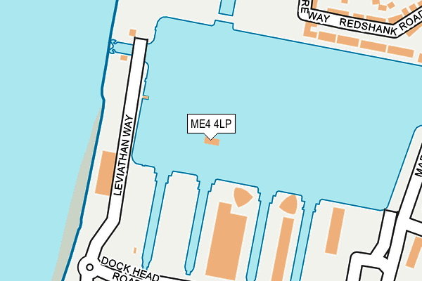
ME4 4LP is located in the St Mary's Island electoral ward, within the unitary authority of Medway and the English Parliamentary constituency of Rochester and Strood. The Sub Integrated Care Board (ICB) Location is NHS Kent and Medway ICB - 91Q and the police force is Kent. This postcode has been in use since December 2001.


GetTheData
Source: OS OpenMap – Local (Ordnance Survey)
Source: OS VectorMap District (Ordnance Survey)
Licence: Open Government Licence (requires attribution)
| Easting | 576202 |
| Northing | 170176 |
| Latitude | 51.403242 |
| Longitude | 0.531856 |
GetTheData
Source: Open Postcode Geo
Licence: Open Government Licence
| Country | England |
| Postcode District | ME4 |
➜ See where ME4 is on a map ➜ Where is Gillingham? | |
GetTheData
Source: Land Registry Price Paid Data
Licence: Open Government Licence
Elevation or altitude of ME4 4LP as distance above sea level:
| Metres | Feet | |
|---|---|---|
| Elevation | 0m | 0ft |
Elevation is measured from the approximate centre of the postcode, to the nearest point on an OS contour line from OS Terrain 50, which has contour spacing of ten vertical metres.
➜ How high above sea level am I? Find the elevation of your current position using your device's GPS.
GetTheData
Source: Open Postcode Elevation
Licence: Open Government Licence
| Ward | St Mary's Island |
| Constituency | Rochester And Strood |
GetTheData
Source: ONS Postcode Database
Licence: Open Government Licence
| Dockside Outlet (Dock Head Road) | Chatham Maritime | 183m |
| Dockside Outlet (Dockhead Road) | Chatham Maritime | 194m |
| Dockside Outlet (Dockhead Road) | Chatham Maritime | 314m |
| Ship And Trades (Maritime Way) | Chatham Maritime | 412m |
| Ship And Trades (Maritime Way) | Chatham Maritime | 426m |
| Gillingham (Kent) Station | 2.2km |
| Strood Station | 2.3km |
| Rochester Station | 2.5km |
GetTheData
Source: NaPTAN
Licence: Open Government Licence
GetTheData
Source: ONS Postcode Database
Licence: Open Government Licence


➜ Get more ratings from the Food Standards Agency
GetTheData
Source: Food Standards Agency
Licence: FSA terms & conditions
| Last Collection | |||
|---|---|---|---|
| Location | Mon-Fri | Sat | Distance |
| Dockhead Road | 17:30 | 11:00 | 224m |
| St Marys Island | 17:30 | 11:30 | 661m |
| Pembroke Gate | 17:30 | 11:30 | 664m |
GetTheData
Source: Dracos
Licence: Creative Commons Attribution-ShareAlike
| Risk of ME4 4LP flooding from rivers and sea | Low |
| ➜ ME4 4LP flood map | |
GetTheData
Source: Open Flood Risk by Postcode
Licence: Open Government Licence
The below table lists the International Territorial Level (ITL) codes (formerly Nomenclature of Territorial Units for Statistics (NUTS) codes) and Local Administrative Units (LAU) codes for ME4 4LP:
| ITL 1 Code | Name |
|---|---|
| TLJ | South East (England) |
| ITL 2 Code | Name |
| TLJ4 | Kent |
| ITL 3 Code | Name |
| TLJ41 | Medway |
| LAU 1 Code | Name |
| E06000035 | Medway |
GetTheData
Source: ONS Postcode Directory
Licence: Open Government Licence
The below table lists the Census Output Area (OA), Lower Layer Super Output Area (LSOA), and Middle Layer Super Output Area (MSOA) for ME4 4LP:
| Code | Name | |
|---|---|---|
| OA | E00081433 | |
| LSOA | E01032798 | Medway 007E |
| MSOA | E02003320 | Medway 007 |
GetTheData
Source: ONS Postcode Directory
Licence: Open Government Licence
| ME4 4ZE | Chatham Quays | 189m |
| ME4 4ZF | Chatham Quays | 189m |
| ME4 4ZH | Chatham Quays | 260m |
| ME4 4ZL | Dock Head Road | 261m |
| ME4 4ZN | Dock Head Road | 261m |
| ME4 4ZS | Dock Head Road | 261m |
| ME4 3ER | Maritime Way | 326m |
| ME4 3RE | Redshank Road | 356m |
| ME4 3SA | Samphire Way | 419m |
| ME4 3NU | Woodlark Road | 461m |
GetTheData
Source: Open Postcode Geo; Land Registry Price Paid Data
Licence: Open Government Licence