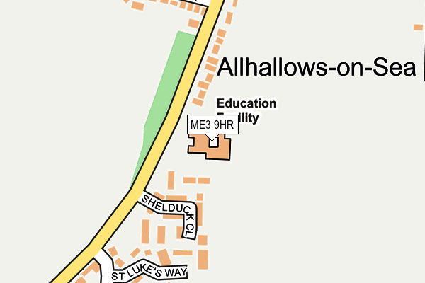
ME3 9HR is located in the All Saints electoral ward, within the unitary authority of Medway and the English Parliamentary constituency of Rochester and Strood. The Sub Integrated Care Board (ICB) Location is NHS Kent and Medway ICB - 91Q and the police force is Kent. This postcode has been in use since January 1980.


GetTheData
Source: OS OpenMap – Local (Ordnance Survey)
Source: OS VectorMap District (Ordnance Survey)
Licence: Open Government Licence (requires attribution)
| Easting | 584005 |
| Northing | 178009 |
| Latitude | 51.471122 |
| Longitude | 0.647950 |
GetTheData
Source: Open Postcode Geo
Licence: Open Government Licence
| Country | England |
| Postcode District | ME3 |
| ➜ ME3 open data dashboard ➜ See where ME3 is on a map ➜ Where is Allhallows? | |
GetTheData
Source: Land Registry Price Paid Data
Licence: Open Government Licence
Elevation or altitude of ME3 9HR as distance above sea level:
| Metres | Feet | |
|---|---|---|
| Elevation | 10m | 33ft |
Elevation is measured from the approximate centre of the postcode, to the nearest point on an OS contour line from OS Terrain 50, which has contour spacing of ten vertical metres.
➜ How high above sea level am I? Find the elevation of your current position using your device's GPS.
GetTheData
Source: Open Postcode Elevation
Licence: Open Government Licence
| Ward | All Saints |
| Constituency | Rochester And Strood |
GetTheData
Source: ONS Postcode Database
Licence: Open Government Licence
| June 2022 | Anti-social behaviour | On or near Shelduck Close | 110m |
| June 2022 | Anti-social behaviour | On or near Shelduck Close | 110m |
| June 2022 | Violence and sexual offences | On or near Shelduck Close | 110m |
| ➜ Get more crime data in our Crime section | |||
GetTheData
Source: data.police.uk
Licence: Open Government Licence
| St Davids Road (Avery Way) | Allhallows | 254m |
| Holiday Village (Avery Way) | Allhallows | 261m |
| Holiday Village (Avery Way) | Allhallows | 305m |
| Kingsmead Caravan Park (Avery Way) | Allhallows | 495m |
| Rose And Crown (Stoke Road) | Allhallows | 600m |
GetTheData
Source: NaPTAN
Licence: Open Government Licence
GetTheData
Source: ONS Postcode Database
Licence: Open Government Licence


➜ Get more ratings from the Food Standards Agency
GetTheData
Source: Food Standards Agency
Licence: FSA terms & conditions
| Last Collection | |||
|---|---|---|---|
| Location | Mon-Fri | Sat | Distance |
| Avery Way/ St Davids Way | 16:00 | 10:30 | 284m |
| Lower Stoke Post Office | 16:30 | 11:00 | 2,265m |
| Upper Stoke | 16:45 | 11:00 | 3,352m |
GetTheData
Source: Dracos
Licence: Creative Commons Attribution-ShareAlike
| Facility | Distance |
|---|---|
| Peninsula East Primary Academy Avery Way, Allhallows, Rochester Grass Pitches | 0m |
| Cross Park Avery Close, Allhallows, Rochester Grass Pitches | 293m |
| Allhallows Leisure Park Allhallows, Rochester Swimming Pool, Outdoor Tennis Courts | 735m |
GetTheData
Source: Active Places
Licence: Open Government Licence
| School | Phase of Education | Distance |
|---|---|---|
| Peninsula East Primary Academy Avery Way, Allhallows, Rochester, ME3 9HR | Primary | 2km |
| St James Church of England Primary Academy High Street, Isle of Grain, Rochester, ME3 0BS | Primary | 4.9km |
| Lubbins Park Primary Academy May Avenue, Canvey Island, SS8 7HF | Primary | 5.9km |
GetTheData
Source: Edubase
Licence: Open Government Licence
The below table lists the International Territorial Level (ITL) codes (formerly Nomenclature of Territorial Units for Statistics (NUTS) codes) and Local Administrative Units (LAU) codes for ME3 9HR:
| ITL 1 Code | Name |
|---|---|
| TLJ | South East (England) |
| ITL 2 Code | Name |
| TLJ4 | Kent |
| ITL 3 Code | Name |
| TLJ41 | Medway |
| LAU 1 Code | Name |
| E06000035 | Medway |
GetTheData
Source: ONS Postcode Directory
Licence: Open Government Licence
The below table lists the Census Output Area (OA), Lower Layer Super Output Area (LSOA), and Middle Layer Super Output Area (MSOA) for ME3 9HR:
| Code | Name | |
|---|---|---|
| OA | E00081238 | |
| LSOA | E01016070 | Medway 001A |
| MSOA | E02003314 | Medway 001 |
GetTheData
Source: ONS Postcode Directory
Licence: Open Government Licence
| ME3 9EJ | Shelduck Close | 113m |
| ME3 9PR | St Lukes Way | 186m |
| ME3 9PX | Avery Way | 215m |
| ME3 9PS | St Davids Road | 216m |
| ME3 9QB | Queensway | 218m |
| ME3 9PP | St Georges Walk | 249m |
| ME3 9QJ | Avery Way | 331m |
| ME3 9PW | St Davids Road | 333m |
| ME3 9QN | Avery Way | 340m |
| ME3 9QX | St Davids Road | 352m |
GetTheData
Source: Open Postcode Geo; Land Registry Price Paid Data
Licence: Open Government Licence