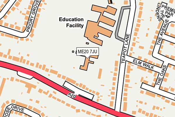
ME20 7JU is located in the Aylesford South & Ditton electoral ward, within the local authority district of Tonbridge and Malling and the English Parliamentary constituency of Chatham and Aylesford. The Sub Integrated Care Board (ICB) Location is NHS Kent and Medway ICB - 91Q and the police force is Kent. This postcode has been in use since January 1980.


GetTheData
Source: OS OpenMap – Local (Ordnance Survey)
Source: OS VectorMap District (Ordnance Survey)
Licence: Open Government Licence (requires attribution)
| Easting | 571887 |
| Northing | 158318 |
| Latitude | 51.298040 |
| Longitude | 0.464130 |
GetTheData
Source: Open Postcode Geo
Licence: Open Government Licence
| Country | England |
| Postcode District | ME20 |
| ➜ ME20 open data dashboard ➜ See where ME20 is on a map ➜ Where is Aylesford? | |
GetTheData
Source: Land Registry Price Paid Data
Licence: Open Government Licence
Elevation or altitude of ME20 7JU as distance above sea level:
| Metres | Feet | |
|---|---|---|
| Elevation | 20m | 66ft |
Elevation is measured from the approximate centre of the postcode, to the nearest point on an OS contour line from OS Terrain 50, which has contour spacing of ten vertical metres.
➜ How high above sea level am I? Find the elevation of your current position using your device's GPS.
GetTheData
Source: Open Postcode Elevation
Licence: Open Government Licence
| Ward | Aylesford South & Ditton |
| Constituency | Chatham And Aylesford |
GetTheData
Source: ONS Postcode Database
Licence: Open Government Licence
| January 2024 | Anti-social behaviour | On or near Station Road | 441m |
| January 2024 | Violence and sexual offences | On or near Station Road | 441m |
| December 2023 | Vehicle crime | On or near Station Road | 441m |
| ➜ Get more crime data in our Crime section | |||
GetTheData
Source: data.police.uk
Licence: Open Government Licence
| School (Teapot Lane) | Aylesford | 158m |
| Teapot Lane (London Road) | Aylesford | 196m |
| Teapot Lane (London Road) | Aylesford | 237m |
| Ta Centre (London Road) | Ditton | 287m |
| Ta Centre (London Road) | Ditton | 336m |
| Aylesford Station | 0.4km |
| New Hythe Station | 1.8km |
| Barming Station | 1.8km |
GetTheData
Source: NaPTAN
Licence: Open Government Licence
| Percentage of properties with Next Generation Access | 100.0% |
| Percentage of properties with Superfast Broadband | 100.0% |
| Percentage of properties with Ultrafast Broadband | 0.0% |
| Percentage of properties with Full Fibre Broadband | 0.0% |
Superfast Broadband is between 30Mbps and 300Mbps
Ultrafast Broadband is > 300Mbps
| Percentage of properties unable to receive 2Mbps | 0.0% |
| Percentage of properties unable to receive 5Mbps | 0.0% |
| Percentage of properties unable to receive 10Mbps | 0.0% |
| Percentage of properties unable to receive 30Mbps | 0.0% |
GetTheData
Source: Ofcom
Licence: Ofcom Terms of Use (requires attribution)
GetTheData
Source: ONS Postcode Database
Licence: Open Government Licence


➜ Get more ratings from the Food Standards Agency
GetTheData
Source: Food Standards Agency
Licence: FSA terms & conditions
| Last Collection | |||
|---|---|---|---|
| Location | Mon-Fri | Sat | Distance |
| Premier Parade | 17:30 | 10:30 | 339m |
| Aylesford Station | 17:45 | 09:00 | 384m |
| Primrose Drive | 17:30 | 09:00 | 453m |
GetTheData
Source: Dracos
Licence: Creative Commons Attribution-ShareAlike
| Facility | Distance |
|---|---|
| Aylesford Primary School Teapot Lane, Aylesford Grass Pitches | 0m |
| Aylesford School Sports College Teapot Lane, Aylesford Sports Hall, Grass Pitches | 93m |
| K Sports Cobdown Station Road, Ditton, Aylesford Grass Pitches, Squash Courts, Artificial Grass Pitch, Health and Fitness Gym | 532m |
GetTheData
Source: Active Places
Licence: Open Government Licence
| School | Phase of Education | Distance |
|---|---|---|
| Aylesford School Teapot Lane, Aylesford, ME20 7JU | Secondary | 93m |
| Valley Invicta Primary School At Aylesford Teapot Lane, Aylesford, ME20 7JU | Primary | 107m |
| Ditton Infant School Pear Tree Avenue, Ditton, Aylesford, ME20 6EB | Primary | 648m |
GetTheData
Source: Edubase
Licence: Open Government Licence
The below table lists the International Territorial Level (ITL) codes (formerly Nomenclature of Territorial Units for Statistics (NUTS) codes) and Local Administrative Units (LAU) codes for ME20 7JU:
| ITL 1 Code | Name |
|---|---|
| TLJ | South East (England) |
| ITL 2 Code | Name |
| TLJ4 | Kent |
| ITL 3 Code | Name |
| TLJ46 | West Kent |
| LAU 1 Code | Name |
| E07000115 | Tonbridge and Malling |
GetTheData
Source: ONS Postcode Directory
Licence: Open Government Licence
The below table lists the Census Output Area (OA), Lower Layer Super Output Area (LSOA), and Middle Layer Super Output Area (MSOA) for ME20 7JU:
| Code | Name | |
|---|---|---|
| OA | E00125471 | |
| LSOA | E01024718 | Tonbridge and Malling 005B |
| MSOA | E02005153 | Tonbridge and Malling 005 |
GetTheData
Source: ONS Postcode Directory
Licence: Open Government Licence
| ME20 6DA | London Road | 125m |
| ME20 7JX | Teapot Lane | 157m |
| ME20 6DB | London Road | 180m |
| ME20 7LS | Elm Walk | 201m |
| ME20 7LR | Elm Walk | 213m |
| ME20 7JT | Teapot Lane | 220m |
| ME20 7LU | Orchard Avenue | 232m |
| ME20 7LF | The Avenue | 241m |
| ME20 7LT | The Oaks | 243m |
| ME20 7JR | Robson Drive | 255m |
GetTheData
Source: Open Postcode Geo; Land Registry Price Paid Data
Licence: Open Government Licence