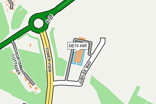
ME19 4NR is located in the Kings Hill electoral ward, within the local authority district of Tonbridge and Malling and the English Parliamentary constituency of Tonbridge and Malling. The Sub Integrated Care Board (ICB) Location is NHS Kent and Medway ICB - 91Q and the police force is Kent. This postcode has been in use since March 2009.


GetTheData
Source: OS OpenMap – Local (Ordnance Survey)
Source: OS VectorMap District (Ordnance Survey)
Licence: Open Government Licence (requires attribution)
| Easting | 567792 |
| Northing | 156232 |
| Latitude | 51.280521 |
| Longitude | 0.404469 |
GetTheData
Source: Open Postcode Geo
Licence: Open Government Licence
| Country | England |
| Postcode District | ME19 |
| ➜ ME19 open data dashboard ➜ See where ME19 is on a map ➜ Where is Kings Hill? | |
GetTheData
Source: Land Registry Price Paid Data
Licence: Open Government Licence
Elevation or altitude of ME19 4NR as distance above sea level:
| Metres | Feet | |
|---|---|---|
| Elevation | 70m | 230ft |
Elevation is measured from the approximate centre of the postcode, to the nearest point on an OS contour line from OS Terrain 50, which has contour spacing of ten vertical metres.
➜ How high above sea level am I? Find the elevation of your current position using your device's GPS.
GetTheData
Source: Open Postcode Elevation
Licence: Open Government Licence
| Ward | Kings Hill |
| Constituency | Tonbridge And Malling |
GetTheData
Source: ONS Postcode Database
Licence: Open Government Licence
| December 2023 | Violence and sexual offences | On or near Tower View | 412m |
| December 2023 | Violence and sexual offences | On or near Tower View | 412m |
| November 2023 | Other theft | On or near Tower View | 412m |
| ➜ Get more crime data in our Crime section | |||
GetTheData
Source: data.police.uk
Licence: Open Government Licence
| Tower View | Kings Hill | 228m |
| Kimberly Clark (Kings Hill Avenue) | Kings Hill | 377m |
| Kimberly Clark (Kings Hill Avenue) | Kings Hill | 420m |
| Teston Road (King Hill) | St Leonard's Street | 619m |
| King Hill | West Malling | 640m |
| West Malling Station | 1.6km |
| East Malling Station | 2.5km |
| Wateringbury Station | 3.6km |
GetTheData
Source: NaPTAN
Licence: Open Government Licence
GetTheData
Source: ONS Postcode Database
Licence: Open Government Licence


➜ Get more ratings from the Food Standards Agency
GetTheData
Source: Food Standards Agency
Licence: FSA terms & conditions
| Last Collection | |||
|---|---|---|---|
| Location | Mon-Fri | Sat | Distance |
| St Leonards | 16:45 | 09:00 | 762m |
| Asda | 18:30 | 11:45 | 912m |
| Kings Hill | 18:30 | 943m | |
GetTheData
Source: Dracos
Licence: Creative Commons Attribution-ShareAlike
| Facility | Distance |
|---|---|
| Infinity Fitness Uk Kings Hill Avenue, Kings Hill, West Malling Health and Fitness Gym, Studio | 839m |
| David Lloyd (Kings Hill) Kings Hill Avenue, Kings Hill, West Malling Sports Hall, Swimming Pool, Health and Fitness Gym, Indoor Tennis Centre, Studio, Squash Courts, Outdoor Tennis Courts | 952m |
| Kings Hill School Crispin Way, Kings Hill, West Malling Grass Pitches | 1.1km |
GetTheData
Source: Active Places
Licence: Open Government Licence
| School | Phase of Education | Distance |
|---|---|---|
| Valley Invicta Primary School At Kings Hill Warwick Way (Off Tower View), Kings Hill, West Malling, ME19 4AL | Primary | 772m |
| Kings Hill School Primary and Nursery Crispin Way, Kings Hill, West Malling, ME19 4LS | Primary | 1.1km |
| The Discovery School Discovery Drive, Kings Hill, West Malling, ME19 4GJ | Primary | 1.3km |
GetTheData
Source: Edubase
Licence: Open Government Licence
The below table lists the International Territorial Level (ITL) codes (formerly Nomenclature of Territorial Units for Statistics (NUTS) codes) and Local Administrative Units (LAU) codes for ME19 4NR:
| ITL 1 Code | Name |
|---|---|
| TLJ | South East (England) |
| ITL 2 Code | Name |
| TLJ4 | Kent |
| ITL 3 Code | Name |
| TLJ46 | West Kent |
| LAU 1 Code | Name |
| E07000115 | Tonbridge and Malling |
GetTheData
Source: ONS Postcode Directory
Licence: Open Government Licence
The below table lists the Census Output Area (OA), Lower Layer Super Output Area (LSOA), and Middle Layer Super Output Area (MSOA) for ME19 4NR:
| Code | Name | |
|---|---|---|
| OA | E00167609 | |
| LSOA | E01032825 | Tonbridge and Malling 007E |
| MSOA | E02005155 | Tonbridge and Malling 007 |
GetTheData
Source: ONS Postcode Directory
Licence: Open Government Licence
| ME19 4PH | Sportsmans Cottages | 226m |
| ME19 4PB | Orwell Spike | 534m |
| ME19 4PL | King Hill | 579m |
| ME19 6PQ | Teston Road | 579m |
| ME19 4YT | Abbey Wood Road | 654m |
| ME19 4NF | Mareda Court | 674m |
| ME19 4AE | Kings Hill Avenue | 678m |
| ME19 6PE | St Leonards Street | 706m |
| ME19 6HR | Lavenders Road | 716m |
| ME19 6HS | Windmill Lane East | 720m |
GetTheData
Source: Open Postcode Geo; Land Registry Price Paid Data
Licence: Open Government Licence