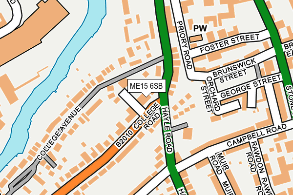
ME15 6SB is located in the High Street electoral ward, within the local authority district of Maidstone and the English Parliamentary constituency of Maidstone and The Weald. The Sub Integrated Care Board (ICB) Location is NHS Kent and Medway ICB - 91Q and the police force is Kent. This postcode has been in use since January 1980.


GetTheData
Source: OS OpenMap – Local (Ordnance Survey)
Source: OS VectorMap District (Ordnance Survey)
Licence: Open Government Licence (requires attribution)
| Easting | 576052 |
| Northing | 155160 |
| Latitude | 51.268400 |
| Longitude | 0.522256 |
GetTheData
Source: Open Postcode Geo
Licence: Open Government Licence
| Country | England |
| Postcode District | ME15 |
| ➜ ME15 open data dashboard ➜ See where ME15 is on a map ➜ Where is Maidstone? | |
GetTheData
Source: Land Registry Price Paid Data
Licence: Open Government Licence
Elevation or altitude of ME15 6SB as distance above sea level:
| Metres | Feet | |
|---|---|---|
| Elevation | 20m | 66ft |
Elevation is measured from the approximate centre of the postcode, to the nearest point on an OS contour line from OS Terrain 50, which has contour spacing of ten vertical metres.
➜ How high above sea level am I? Find the elevation of your current position using your device's GPS.
GetTheData
Source: Open Postcode Elevation
Licence: Open Government Licence
| Ward | High Street |
| Constituency | Maidstone And The Weald |
GetTheData
Source: ONS Postcode Database
Licence: Open Government Licence
| January 2024 | Other theft | On or near Parking Area | 185m |
| January 2024 | Violence and sexual offences | On or near Parking Area | 185m |
| January 2024 | Violence and sexual offences | On or near Parking Area | 185m |
| ➜ Get more crime data in our Crime section | |||
GetTheData
Source: data.police.uk
Licence: Open Government Licence
| Hayle Road | Maidstone | 78m |
| Music School (Hayle Road) | Maidstone | 124m |
| Coombe Road (Old Tovil Road) | Maidstone | 319m |
| Lockmeadow (Barker Road) | Maidstone | 321m |
| Coombe Road (Old Tovil Road) | Maidstone | 328m |
| Maidstone West Station | 0.5km |
| Maidstone East Station | 1.1km |
| Maidstone Barracks Station | 1.1km |
GetTheData
Source: NaPTAN
Licence: Open Government Licence
GetTheData
Source: ONS Postcode Database
Licence: Open Government Licence


➜ Get more ratings from the Food Standards Agency
GetTheData
Source: Food Standards Agency
Licence: FSA terms & conditions
| Last Collection | |||
|---|---|---|---|
| Location | Mon-Fri | Sat | Distance |
| Hayle Road | 17:45 | 12:30 | 45m |
| Palace Avenue | 18:00 | 12:30 | 334m |
| Lower Stone Street | 17:45 | 12:00 | 355m |
GetTheData
Source: Dracos
Licence: Creative Commons Attribution-ShareAlike
| Facility | Distance |
|---|---|
| Hillreed House (Closed) College Road, Maidstone Sports Hall | 136m |
| Lockmeadow Health Club Lockmeadow Leisure Complex, Barker Road, Maidstone Swimming Pool, Health and Fitness Gym, Studio | 265m |
| Snap Fitness (Maidstone) High Street, High Street, Maidstone Health and Fitness Gym | 517m |
GetTheData
Source: Active Places
Licence: Open Government Licence
| School | Phase of Education | Distance |
|---|---|---|
| Archbishop Courtenay Primary School Eccleston Road, Tovil, Maidstone, ME15 6QN | Primary | 549m |
| OneSchool Global UK - Maidstone Campus Heath Road, Linton, Maidstone, ME17 4HT | Not applicable | 613m |
| South Borough Primary School Stagshaw Close, Postley Road, Maidstone, ME15 6TL | Primary | 625m |
GetTheData
Source: Edubase
Licence: Open Government Licence
The below table lists the International Territorial Level (ITL) codes (formerly Nomenclature of Territorial Units for Statistics (NUTS) codes) and Local Administrative Units (LAU) codes for ME15 6SB:
| ITL 1 Code | Name |
|---|---|
| TLJ | South East (England) |
| ITL 2 Code | Name |
| TLJ4 | Kent |
| ITL 3 Code | Name |
| TLJ45 | Mid Kent |
| LAU 1 Code | Name |
| E07000110 | Maidstone |
GetTheData
Source: ONS Postcode Directory
Licence: Open Government Licence
The below table lists the Census Output Area (OA), Lower Layer Super Output Area (LSOA), and Middle Layer Super Output Area (MSOA) for ME15 6SB:
| Code | Name | |
|---|---|---|
| OA | E00123729 | |
| LSOA | E01024373 | Maidstone 006E |
| MSOA | E02005073 | Maidstone 006 |
GetTheData
Source: ONS Postcode Directory
Licence: Open Government Licence
| ME15 6SH | Greenhithe | 65m |
| ME15 6YH | College Road | 83m |
| ME15 6PB | College Court | 108m |
| ME15 6NW | Priory Road | 122m |
| ME15 6YF | College Road | 124m |
| ME15 6PF | Hayle Road | 125m |
| ME15 6NR | Orchard Street | 130m |
| ME15 6PD | Hayle Road | 135m |
| ME15 6YJ | College Avenue | 144m |
| ME15 6NU | Orchard Close | 145m |
GetTheData
Source: Open Postcode Geo; Land Registry Price Paid Data
Licence: Open Government Licence