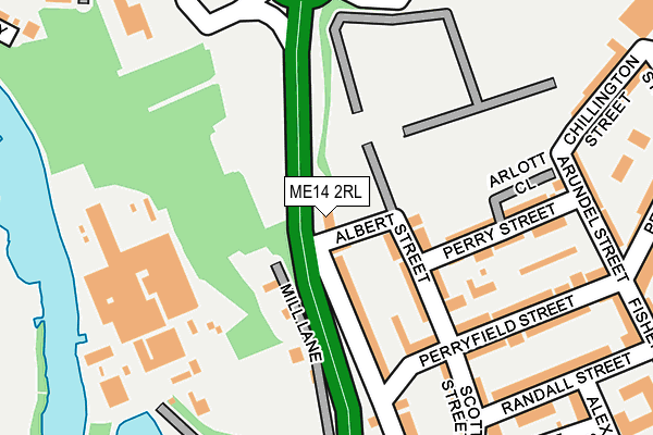
ME14 2RL is located in the North electoral ward, within the local authority district of Maidstone and the English Parliamentary constituency of Maidstone and The Weald. The Sub Integrated Care Board (ICB) Location is NHS Kent and Medway ICB - 91Q and the police force is Kent. This postcode has been in use since January 1980.


GetTheData
Source: OS OpenMap – Local (Ordnance Survey)
Source: OS VectorMap District (Ordnance Survey)
Licence: Open Government Licence (requires attribution)
| Easting | 575740 |
| Northing | 156741 |
| Latitude | 51.282699 |
| Longitude | 0.518565 |
GetTheData
Source: Open Postcode Geo
Licence: Open Government Licence
| Country | England |
| Postcode District | ME14 |
| ➜ ME14 open data dashboard ➜ See where ME14 is on a map ➜ Where is Maidstone? | |
GetTheData
Source: Land Registry Price Paid Data
Licence: Open Government Licence
Elevation or altitude of ME14 2RL as distance above sea level:
| Metres | Feet | |
|---|---|---|
| Elevation | 20m | 66ft |
Elevation is measured from the approximate centre of the postcode, to the nearest point on an OS contour line from OS Terrain 50, which has contour spacing of ten vertical metres.
➜ How high above sea level am I? Find the elevation of your current position using your device's GPS.
GetTheData
Source: Open Postcode Elevation
Licence: Open Government Licence
| Ward | North |
| Constituency | Maidstone And The Weald |
GetTheData
Source: ONS Postcode Database
Licence: Open Government Licence
| January 2024 | Violence and sexual offences | On or near Parking Area | 226m |
| September 2023 | Anti-social behaviour | On or near Parking Area | 226m |
| September 2023 | Anti-social behaviour | On or near Parking Area | 226m |
| ➜ Get more crime data in our Crime section | |||
GetTheData
Source: data.police.uk
Licence: Open Government Licence
| Springfield (Royal Engineers' Road) | Maidstone | 56m |
| Springfield (Royal Engineers' Road) | Maidstone | 120m |
| Kent History And Library Centre (Royal Engineers' Road) | Maidstone | 192m |
| Kent History And Library Centre (Royal Engineers' Road) | Maidstone | 210m |
| Moncktons Lane (Chatham Road) | Maidstone | 328m |
| Maidstone East Station | 0.6km |
| Maidstone Barracks Station | 0.7km |
| Maidstone West Station | 1.4km |
GetTheData
Source: NaPTAN
Licence: Open Government Licence
GetTheData
Source: ONS Postcode Database
Licence: Open Government Licence


➜ Get more ratings from the Food Standards Agency
GetTheData
Source: Food Standards Agency
Licence: FSA terms & conditions
| Last Collection | |||
|---|---|---|---|
| Location | Mon-Fri | Sat | Distance |
| Maidstone Mail Centre | 440m | ||
| Maidstone Mail Centre | 19:30 | 13:30 | 452m |
| Maidstone Mail Centre | 19:30 | 13:30 | 456m |
GetTheData
Source: Dracos
Licence: Creative Commons Attribution-ShareAlike
| Facility | Distance |
|---|---|
| The Gallagher Stadium James Whatman Way, Maidstone Artificial Grass Pitch | 374m |
| Howard De Walden Community Centre Bluett Street, Maidstone Sports Hall | 563m |
| Maidstone Grammar School For Girls Buckland Road, Maidstone Grass Pitches, Sports Hall, Studio | 565m |
GetTheData
Source: Active Places
Licence: Open Government Licence
| School | Phase of Education | Distance |
|---|---|---|
| North Borough Junior School North Borough Junior School, Peel Street, Maidstone, ME14 2BP | Primary | 466m |
| Maidstone Grammar School for Girls Buckland Road, Maidstone, ME16 0SF | Secondary | 565m |
| St Paul's Infant School Hillary Road, Maidstone, ME14 2BS | Primary | 570m |
GetTheData
Source: Edubase
Licence: Open Government Licence
The below table lists the International Territorial Level (ITL) codes (formerly Nomenclature of Territorial Units for Statistics (NUTS) codes) and Local Administrative Units (LAU) codes for ME14 2RL:
| ITL 1 Code | Name |
|---|---|
| TLJ | South East (England) |
| ITL 2 Code | Name |
| TLJ4 | Kent |
| ITL 3 Code | Name |
| TLJ45 | Mid Kent |
| LAU 1 Code | Name |
| E07000110 | Maidstone |
GetTheData
Source: ONS Postcode Directory
Licence: Open Government Licence
The below table lists the Census Output Area (OA), Lower Layer Super Output Area (LSOA), and Middle Layer Super Output Area (MSOA) for ME14 2RL:
| Code | Name | |
|---|---|---|
| OA | E00123775 | |
| LSOA | E01024383 | Maidstone 004D |
| MSOA | E02005071 | Maidstone 004 |
GetTheData
Source: ONS Postcode Directory
Licence: Open Government Licence
| ME14 2RN | Albert Street | 68m |
| ME14 2RJ | Sandling Road | 98m |
| ME14 2RW | Albert Street | 119m |
| ME14 2SY | Perryfield Street | 144m |
| ME14 2SS | Thurlestone Court | 156m |
| ME14 2RP | Perry Street | 167m |
| ME14 2SX | Perryfield Street | 191m |
| ME14 2SZ | Perryfield Street | 200m |
| ME14 2RZ | Wellington Place | 207m |
| ME14 2TA | Scott Street | 211m |
GetTheData
Source: Open Postcode Geo; Land Registry Price Paid Data
Licence: Open Government Licence