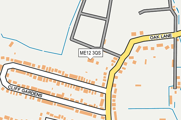
ME12 3QS is located in the Minster Cliffs electoral ward, within the local authority district of Swale and the English Parliamentary constituency of Sittingbourne and Sheppey. The Sub Integrated Care Board (ICB) Location is NHS Kent and Medway ICB - 91Q and the police force is Kent. This postcode has been in use since January 1980.


GetTheData
Source: OS OpenMap – Local (Ordnance Survey)
Source: OS VectorMap District (Ordnance Survey)
Licence: Open Government Licence (requires attribution)
| Easting | 596403 |
| Northing | 173055 |
| Latitude | 51.422468 |
| Longitude | 0.823486 |
GetTheData
Source: Open Postcode Geo
Licence: Open Government Licence
| Country | England |
| Postcode District | ME12 |
| ➜ ME12 open data dashboard ➜ See where ME12 is on a map ➜ Where is Minster? | |
GetTheData
Source: Land Registry Price Paid Data
Licence: Open Government Licence
Elevation or altitude of ME12 3QS as distance above sea level:
| Metres | Feet | |
|---|---|---|
| Elevation | 50m | 164ft |
Elevation is measured from the approximate centre of the postcode, to the nearest point on an OS contour line from OS Terrain 50, which has contour spacing of ten vertical metres.
➜ How high above sea level am I? Find the elevation of your current position using your device's GPS.
GetTheData
Source: Open Postcode Elevation
Licence: Open Government Licence
| Ward | Minster Cliffs |
| Constituency | Sittingbourne And Sheppey |
GetTheData
Source: ONS Postcode Database
Licence: Open Government Licence
| November 2023 | Criminal damage and arson | On or near Oak Lane | 251m |
| June 2023 | Criminal damage and arson | On or near Oak Lane | 251m |
| June 2023 | Criminal damage and arson | On or near Oak Lane | 251m |
| ➜ Get more crime data in our Crime section | |||
GetTheData
Source: data.police.uk
Licence: Open Government Licence
| Mill Hill (Chequers Road) | Minster | 330m |
| British Queen (Chequers Road) | Minster | 338m |
| British Queen (Chequers Road) | Minster | 342m |
| Mill Hill (Chequers Road) | Minster | 354m |
| Tams Gardens (Chapel Street) | Minster | 463m |
| Sheerness-on-Sea Station | 5km |
GetTheData
Source: NaPTAN
Licence: Open Government Licence
GetTheData
Source: ONS Postcode Database
Licence: Open Government Licence


➜ Get more ratings from the Food Standards Agency
GetTheData
Source: Food Standards Agency
Licence: FSA terms & conditions
| Last Collection | |||
|---|---|---|---|
| Location | Mon-Fri | Sat | Distance |
| Oak Lane | 16:00 | 08:00 | 239m |
| Minster On Sea Post Office | 16:30 | 11:30 | 657m |
| Queens Road | 16:15 | 09:00 | 894m |
GetTheData
Source: Dracos
Licence: Creative Commons Attribution-ShareAlike
| Facility | Distance |
|---|---|
| St George's Church Of England Primary School Chequers Road, Minster On Sea, Sheerness Sports Hall, Grass Pitches | 472m |
| Gilbert Hall Chequers Road, Minster-on-sea Grass Pitches | 542m |
| Thistle Hill Playing Field Thistle Hill Way, Thistle Hill Way, Minster-on-sea Grass Pitches | 1.9km |
GetTheData
Source: Active Places
Licence: Open Government Licence
| School | Phase of Education | Distance |
|---|---|---|
| St Georges CofE (Aided) Primary School Chequers Road, Sheerness, ME12 3QU | Primary | 469m |
| Minster in Sheppey Primary School Brecon Chase, Minster, Sheerness, ME12 2HX | Primary | 1km |
| Thistle Hill Academy Aspen Drive, Minster-on-Sea, Sheerness, ME12 3UD | Primary | 1.8km |
GetTheData
Source: Edubase
Licence: Open Government Licence
The below table lists the International Territorial Level (ITL) codes (formerly Nomenclature of Territorial Units for Statistics (NUTS) codes) and Local Administrative Units (LAU) codes for ME12 3QS:
| ITL 1 Code | Name |
|---|---|
| TLJ | South East (England) |
| ITL 2 Code | Name |
| TLJ4 | Kent |
| ITL 3 Code | Name |
| TLJ43 | Kent Thames Gateway |
| LAU 1 Code | Name |
| E07000113 | Swale |
GetTheData
Source: ONS Postcode Directory
Licence: Open Government Licence
The below table lists the Census Output Area (OA), Lower Layer Super Output Area (LSOA), and Middle Layer Super Output Area (MSOA) for ME12 3QS:
| Code | Name | |
|---|---|---|
| OA | E00124789 | |
| LSOA | E01024586 | Swale 006C |
| MSOA | E02005120 | Swale 006 |
GetTheData
Source: ONS Postcode Directory
Licence: Open Government Licence
| ME12 3QP | Oak Lane | 116m |
| ME12 3QY | Cliff Gardens | 150m |
| ME12 3QW | Oak Lane | 168m |
| ME12 3QZ | Cliff Gardens | 174m |
| ME12 3QA | Windmill Rise | 246m |
| ME12 3QN | Oak Lane | 271m |
| ME12 3QT | Oak Avenue | 280m |
| ME12 3QL | Chequers Road | 337m |
| ME12 3SH | Chequers Road | 355m |
| ME12 3QX | Danedale Avenue | 406m |
GetTheData
Source: Open Postcode Geo; Land Registry Price Paid Data
Licence: Open Government Licence