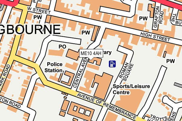
ME10 4AH is located in the Homewood electoral ward, within the local authority district of Swale and the English Parliamentary constituency of Sittingbourne and Sheppey. The Sub Integrated Care Board (ICB) Location is NHS Kent and Medway ICB - 91Q and the police force is Kent. This postcode has been in use since January 1980.


GetTheData
Source: OS OpenMap – Local (Ordnance Survey)
Source: OS VectorMap District (Ordnance Survey)
Licence: Open Government Licence (requires attribution)
| Easting | 590606 |
| Northing | 163541 |
| Latitude | 51.338997 |
| Longitude | 0.735110 |
GetTheData
Source: Open Postcode Geo
Licence: Open Government Licence
| Country | England |
| Postcode District | ME10 |
| ➜ ME10 open data dashboard ➜ See where ME10 is on a map ➜ Where is Sittingbourne? | |
GetTheData
Source: Land Registry Price Paid Data
Licence: Open Government Licence
Elevation or altitude of ME10 4AH as distance above sea level:
| Metres | Feet | |
|---|---|---|
| Elevation | 20m | 66ft |
Elevation is measured from the approximate centre of the postcode, to the nearest point on an OS contour line from OS Terrain 50, which has contour spacing of ten vertical metres.
➜ How high above sea level am I? Find the elevation of your current position using your device's GPS.
GetTheData
Source: Open Postcode Elevation
Licence: Open Government Licence
| Ward | Homewood |
| Constituency | Sittingbourne And Sheppey |
GetTheData
Source: ONS Postcode Database
Licence: Open Government Licence
| January 2024 | Anti-social behaviour | On or near Parking Area | 247m |
| January 2024 | Anti-social behaviour | On or near Parking Area | 247m |
| January 2024 | Anti-social behaviour | On or near Parking Area | 247m |
| ➜ Get more crime data in our Crime section | |||
GetTheData
Source: data.police.uk
Licence: Open Government Licence
| Borden Grammar School (Avenue Of Remembrance) | Sittingbourne | 119m |
| High Street | Sittingbourne | 150m |
| Borden Grammar School (Avenue Of Remembrance) | Sittingbourne | 201m |
| Forum Shopping Centre (Station Street) | Sittingbourne | 228m |
| Globe And Engine (St Michael's Road) | Sittingbourne | 260m |
| Sittingbourne Station | 0.3km |
| Kemsley Station | 2.6km |
| Newington Station | 4.9km |
GetTheData
Source: NaPTAN
Licence: Open Government Licence
GetTheData
Source: ONS Postcode Database
Licence: Open Government Licence


➜ Get more ratings from the Food Standards Agency
GetTheData
Source: Food Standards Agency
Licence: FSA terms & conditions
| Last Collection | |||
|---|---|---|---|
| Location | Mon-Fri | Sat | Distance |
| Central Avenue | 18:30 | 10:15 | 47m |
| Sittingbourne P.o. Meter Box | 53m | ||
| High Street | 18:15 | 12:15 | 229m |
GetTheData
Source: Dracos
Licence: Creative Commons Attribution-ShareAlike
| Facility | Distance |
|---|---|
| Swallows Leisure Centre Central Avenue, Sittingbourne Sports Hall, Swimming Pool, Health and Fitness Gym, Squash Courts, Studio | 43m |
| Borden Grammar School Avenue Of Remembrance, Sittingbourne Grass Pitches, Sports Hall, Artificial Grass Pitch, Outdoor Tennis Courts | 184m |
| Sittingbourne Recreation Ground Albany Road, Sittingbourne Grass Pitches | 435m |
GetTheData
Source: Active Places
Licence: Open Government Licence
| School | Phase of Education | Distance |
|---|---|---|
| Borden Grammar School Avenue of Remembrance, Sittingbourne, ME10 4DB | Secondary | 184m |
| Highsted Grammar School Highsted Road, Sittingbourne, ME10 4PT | Secondary | 609m |
| Fulston Manor School Brenchley Road, Sittingbourne, ME10 4EG | Secondary | 699m |
GetTheData
Source: Edubase
Licence: Open Government Licence
The below table lists the International Territorial Level (ITL) codes (formerly Nomenclature of Territorial Units for Statistics (NUTS) codes) and Local Administrative Units (LAU) codes for ME10 4AH:
| ITL 1 Code | Name |
|---|---|
| TLJ | South East (England) |
| ITL 2 Code | Name |
| TLJ4 | Kent |
| ITL 3 Code | Name |
| TLJ43 | Kent Thames Gateway |
| LAU 1 Code | Name |
| E07000113 | Swale |
GetTheData
Source: ONS Postcode Directory
Licence: Open Government Licence
The below table lists the Census Output Area (OA), Lower Layer Super Output Area (LSOA), and Middle Layer Super Output Area (MSOA) for ME10 4AH:
| Code | Name | |
|---|---|---|
| OA | E00124883 | |
| LSOA | E01024608 | Swale 010E |
| MSOA | E02005124 | Swale 010 |
GetTheData
Source: ONS Postcode Directory
Licence: Open Government Licence
| ME10 4AJ | High Street | 120m |
| ME10 4BJ | Roman Square | 127m |
| ME10 4PB | High Street | 141m |
| ME10 4PH | High Street | 146m |
| ME10 4AQ | High Street | 167m |
| ME10 4PL | High Street | 179m |
| ME10 4AW | High Street | 186m |
| ME10 1EB | Albany Road | 222m |
| ME10 4DE | Avenue Of Remembrance | 234m |
| ME10 4PD | High Street | 245m |
GetTheData
Source: Open Postcode Geo; Land Registry Price Paid Data
Licence: Open Government Licence