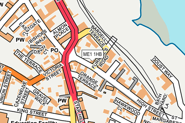
ME1 1HB is located in the Rochester West & Borstal electoral ward, within the unitary authority of Medway and the English Parliamentary constituency of Rochester and Strood. The Sub Integrated Care Board (ICB) Location is NHS Kent and Medway ICB - 91Q and the police force is Kent. This postcode has been in use since January 1980.


GetTheData
Source: OS OpenMap – Local (Ordnance Survey)
Source: OS VectorMap District (Ordnance Survey)
Licence: Open Government Licence (requires attribution)
| Easting | 574704 |
| Northing | 168135 |
| Latitude | 51.385370 |
| Longitude | 0.509338 |
GetTheData
Source: Open Postcode Geo
Licence: Open Government Licence
| Country | England |
| Postcode District | ME1 |
➜ See where ME1 is on a map ➜ Where is Rochester? | |
GetTheData
Source: Land Registry Price Paid Data
Licence: Open Government Licence
Elevation or altitude of ME1 1HB as distance above sea level:
| Metres | Feet | |
|---|---|---|
| Elevation | 10m | 33ft |
Elevation is measured from the approximate centre of the postcode, to the nearest point on an OS contour line from OS Terrain 50, which has contour spacing of ten vertical metres.
➜ How high above sea level am I? Find the elevation of your current position using your device's GPS.
GetTheData
Source: Open Postcode Elevation
Licence: Open Government Licence
| Ward | Rochester West & Borstal |
| Constituency | Rochester And Strood |
GetTheData
Source: ONS Postcode Database
Licence: Open Government Licence
| Furrell's Road (High Street) | Rochester | 30m |
| Furrell's Road (High Street) | Rochester | 35m |
| Star Hill | Rochester | 101m |
| Star Hill | Rochester | 131m |
| Delce Road | Rochester | 161m |
| Rochester Station | 0.1km |
| Chatham Station | 1km |
| Strood Station | 1.4km |
GetTheData
Source: NaPTAN
Licence: Open Government Licence
GetTheData
Source: ONS Postcode Database
Licence: Open Government Licence


➜ Get more ratings from the Food Standards Agency
GetTheData
Source: Food Standards Agency
Licence: FSA terms & conditions
| Last Collection | |||
|---|---|---|---|
| Location | Mon-Fri | Sat | Distance |
| Rochester Old Post Office | 18:30 | 11:30 | 161m |
| Eastgate | 18:30 | 11:30 | 289m |
| New Road | 17:45 | 11:30 | 302m |
GetTheData
Source: Dracos
Licence: Creative Commons Attribution-ShareAlike
| Risk of ME1 1HB flooding from rivers and sea | Low |
| ➜ ME1 1HB flood map | |
GetTheData
Source: Open Flood Risk by Postcode
Licence: Open Government Licence
The below table lists the International Territorial Level (ITL) codes (formerly Nomenclature of Territorial Units for Statistics (NUTS) codes) and Local Administrative Units (LAU) codes for ME1 1HB:
| ITL 1 Code | Name |
|---|---|
| TLJ | South East (England) |
| ITL 2 Code | Name |
| TLJ4 | Kent |
| ITL 3 Code | Name |
| TLJ41 | Medway |
| LAU 1 Code | Name |
| E06000035 | Medway |
GetTheData
Source: ONS Postcode Directory
Licence: Open Government Licence
The below table lists the Census Output Area (OA), Lower Layer Super Output Area (LSOA), and Middle Layer Super Output Area (MSOA) for ME1 1HB:
| Code | Name | |
|---|---|---|
| OA | E00081423 | |
| LSOA | E01016110 | Medway 015D |
| MSOA | E02003328 | Medway 015 |
GetTheData
Source: ONS Postcode Directory
Licence: Open Government Licence
| ME1 1JG | Rochester Gate | 65m |
| ME1 1HX | High Street | 76m |
| ME1 1XE | Orange Terrace | 77m |
| ME1 1HY | St Margarets Banks | 80m |
| ME1 1JA | High Street | 96m |
| ME1 1HQ | High Street | 100m |
| ME1 1GA | Star Hill | 102m |
| ME1 1XB | Star Hill | 131m |
| ME1 1XF | Star Hill | 137m |
| ME1 1GB | Star Hill | 142m |
GetTheData
Source: Open Postcode Geo; Land Registry Price Paid Data
Licence: Open Government Licence