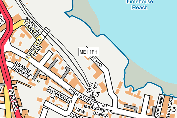
ME1 1FH is located in the Fort Pitt electoral ward, within the unitary authority of Medway and the English Parliamentary constituency of Rochester and Strood. The Sub Integrated Care Board (ICB) Location is NHS Kent and Medway ICB - 91Q and the police force is Kent. This postcode has been in use since April 2013.


GetTheData
Source: OS OpenMap – Local (Ordnance Survey)
Source: OS VectorMap District (Ordnance Survey)
Licence: Open Government Licence (requires attribution)
| Easting | 574887 |
| Northing | 168125 |
| Latitude | 51.385225 |
| Longitude | 0.511931 |
GetTheData
Source: Open Postcode Geo
Licence: Open Government Licence
| Country | England |
| Postcode District | ME1 |
| ➜ ME1 open data dashboard ➜ See where ME1 is on a map ➜ Where is Rochester? | |
GetTheData
Source: Land Registry Price Paid Data
Licence: Open Government Licence
Elevation or altitude of ME1 1FH as distance above sea level:
| Metres | Feet | |
|---|---|---|
| Elevation | 10m | 33ft |
Elevation is measured from the approximate centre of the postcode, to the nearest point on an OS contour line from OS Terrain 50, which has contour spacing of ten vertical metres.
➜ How high above sea level am I? Find the elevation of your current position using your device's GPS.
GetTheData
Source: Open Postcode Elevation
Licence: Open Government Licence
| Ward | Fort Pitt |
| Constituency | Rochester And Strood |
GetTheData
Source: ONS Postcode Database
Licence: Open Government Licence
| December 2023 | Theft from the person | On or near Parking Area | 199m |
| December 2023 | Violence and sexual offences | On or near Parking Area | 199m |
| December 2023 | Violence and sexual offences | On or near Parking Area | 199m |
| ➜ Get more crime data in our Crime section | |||
GetTheData
Source: data.police.uk
Licence: Open Government Licence
| Bath Hard Lane (High Street) | Rochester | 126m |
| Bath Hard Lane (High Street) | Rochester | 173m |
| Furrell's Road (High Street) | Rochester | 211m |
| Furrell's Road (High Street) | Rochester | 218m |
| Jacksons Fields (New Road) | Rochester | 264m |
| Rochester Station | 0.1km |
| Chatham Station | 0.8km |
| Strood Station | 1.5km |
GetTheData
Source: NaPTAN
Licence: Open Government Licence
| Percentage of properties with Next Generation Access | 100.0% |
| Percentage of properties with Superfast Broadband | 100.0% |
| Percentage of properties with Ultrafast Broadband | 100.0% |
| Percentage of properties with Full Fibre Broadband | 100.0% |
Superfast Broadband is between 30Mbps and 300Mbps
Ultrafast Broadband is > 300Mbps
| Percentage of properties unable to receive 2Mbps | 0.0% |
| Percentage of properties unable to receive 5Mbps | 0.0% |
| Percentage of properties unable to receive 10Mbps | 0.0% |
| Percentage of properties unable to receive 30Mbps | 0.0% |
GetTheData
Source: Ofcom
Licence: Ofcom Terms of Use (requires attribution)
GetTheData
Source: ONS Postcode Database
Licence: Open Government Licence


➜ Get more ratings from the Food Standards Agency
GetTheData
Source: Food Standards Agency
Licence: FSA terms & conditions
| Last Collection | |||
|---|---|---|---|
| Location | Mon-Fri | Sat | Distance |
| St Margarets Bank | 18:30 | 11:30 | 263m |
| New Road | 17:45 | 11:30 | 266m |
| Rochester Old Post Office | 18:30 | 11:30 | 336m |
GetTheData
Source: Dracos
Licence: Creative Commons Attribution-ShareAlike
| Facility | Distance |
|---|---|
| Roffen Sports Club (Closed) New Road, Rochester Swimming Pool, Health and Fitness Gym, Studio, Squash Courts, Outdoor Tennis Courts | 277m |
| Rochester Independent College Star Hill, Rochester Sports Hall | 277m |
| Fort Pitt Grammar School Fort Pitt Hill, Chatham Health and Fitness Gym, Grass Pitches, Sports Hall | 537m |
GetTheData
Source: Active Places
Licence: Open Government Licence
| School | Phase of Education | Distance |
|---|---|---|
| Ripplevale School Rochester 9-13 New Road, Rochester, Kent, Rochester, ME1 1BG | Not applicable | 245m |
| Rochester Independent College Star Hill, Rochester, ME1 1XF | Not applicable | 276m |
| Sports Connect 62 Mierscourt Road, Banky Farm, Gillingham, ME8 8PH | Not applicable | 431m |
GetTheData
Source: Edubase
Licence: Open Government Licence
The below table lists the International Territorial Level (ITL) codes (formerly Nomenclature of Territorial Units for Statistics (NUTS) codes) and Local Administrative Units (LAU) codes for ME1 1FH:
| ITL 1 Code | Name |
|---|---|
| TLJ | South East (England) |
| ITL 2 Code | Name |
| TLJ4 | Kent |
| ITL 3 Code | Name |
| TLJ41 | Medway |
| LAU 1 Code | Name |
| E06000035 | Medway |
GetTheData
Source: ONS Postcode Directory
Licence: Open Government Licence
The below table lists the Census Output Area (OA), Lower Layer Super Output Area (LSOA), and Middle Layer Super Output Area (MSOA) for ME1 1FH:
| Code | Name | |
|---|---|---|
| OA | E00081423 | |
| LSOA | E01016110 | Medway 015D |
| MSOA | E02003328 | Medway 015 |
GetTheData
Source: ONS Postcode Directory
Licence: Open Government Licence
| ME1 1HN | High Street | 108m |
| ME1 1FF | Doust Way | 112m |
| ME1 1HQ | High Street | 118m |
| ME1 1HX | High Street | 127m |
| ME1 1HT | St Margarets Banks | 132m |
| ME1 1HS | St Margarets Banks | 153m |
| ME1 1HY | St Margarets Banks | 161m |
| ME1 1HW | Hawkwood Close | 168m |
| ME1 1BB | Nags Head Lane | 188m |
| ME1 1BY | Gills Cottages | 198m |
GetTheData
Source: Open Postcode Geo; Land Registry Price Paid Data
Licence: Open Government Licence