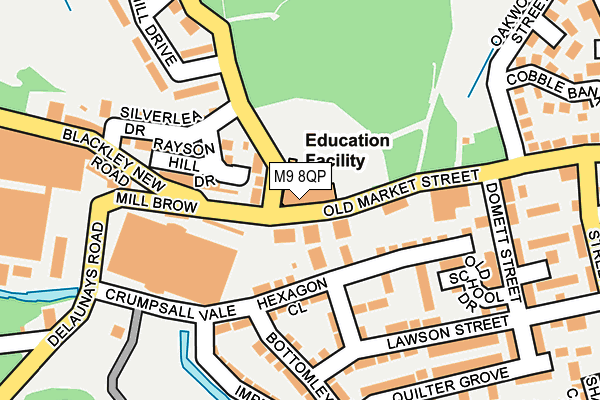
M9 8QP is located in the Higher Blackley electoral ward, within the metropolitan district of Manchester and the English Parliamentary constituency of Blackley and Broughton. The Sub Integrated Care Board (ICB) Location is NHS Greater Manchester ICB - 14L and the police force is Greater Manchester. This postcode has been in use since February 2013.


GetTheData
Source: OS OpenMap – Local (Ordnance Survey)
Source: OS VectorMap District (Ordnance Survey)
Licence: Open Government Licence (requires attribution)
| Easting | 385262 |
| Northing | 402910 |
| Latitude | 53.522648 |
| Longitude | -2.223766 |
GetTheData
Source: Open Postcode Geo
Licence: Open Government Licence
| Country | England |
| Postcode District | M9 |
| ➜ M9 open data dashboard ➜ See where M9 is on a map ➜ Where is Manchester? | |
GetTheData
Source: Land Registry Price Paid Data
Licence: Open Government Licence
Elevation or altitude of M9 8QP as distance above sea level:
| Metres | Feet | |
|---|---|---|
| Elevation | 60m | 197ft |
Elevation is measured from the approximate centre of the postcode, to the nearest point on an OS contour line from OS Terrain 50, which has contour spacing of ten vertical metres.
➜ How high above sea level am I? Find the elevation of your current position using your device's GPS.
GetTheData
Source: Open Postcode Elevation
Licence: Open Government Licence
| Ward | Higher Blackley |
| Constituency | Blackley And Broughton |
GetTheData
Source: ONS Postcode Database
Licence: Open Government Licence
| Chapel Lane (Nth Bnd) (Chapel Lane) | Higher Crumpsall | 30m |
| Old Market St/Pike Fold Primary Sch (Old Market St) | Higher Crumpsall | 67m |
| Old Market St/Chapel Ln (Old Market St) | Higher Crumpsall | 68m |
| Old Market St/Pike Fold Primary Sch (Old Market St) | Higher Crumpsall | 72m |
| Old Market St/Chapel Ln (Old Market St) | Higher Crumpsall | 77m |
| Crumpsall (Manchester Metrolink) (Off Station Road) | Higher Crumpsall | 1,284m |
| Abraham Moss (Manchester Metrolink) (Woodlands Road) | Cheetham Hill | 1,553m |
| Moston Station | 3.5km |
| Manchester Victoria Station | 4.1km |
| Mills Hill (Manchester) Station | 4.7km |
GetTheData
Source: NaPTAN
Licence: Open Government Licence
GetTheData
Source: ONS Postcode Database
Licence: Open Government Licence


➜ Get more ratings from the Food Standards Agency
GetTheData
Source: Food Standards Agency
Licence: FSA terms & conditions
| Last Collection | |||
|---|---|---|---|
| Location | Mon-Fri | Sat | Distance |
| Riverdale Road P.o. | 17:30 | 12:00 | 577m |
| Delaunetys Road | 17:30 | 11:45 | 698m |
| Barnes Green P.o. | 17:30 | 12:00 | 815m |
GetTheData
Source: Dracos
Licence: Creative Commons Attribution-ShareAlike
| Facility | Distance |
|---|---|
| The Body Matrix (Closed) Old Market Street, Manchester Health and Fitness Gym, Studio | 435m |
| Co-op Academy Manchester Plant Hill Road, Manchester Grass Pitches, Sports Hall, Swimming Pool, Studio, Artificial Grass Pitch, Health and Fitness Gym | 787m |
| Plant Hill Park Plant Hill Road, Manchester Grass Pitches | 810m |
GetTheData
Source: Active Places
Licence: Open Government Licence
| School | Phase of Education | Distance |
|---|---|---|
| Pike Fold Primary School Old Market Street, Blackley, Manchester, M9 8QP | Primary | 10m |
| Prospect House Specialist Support Primary School 56 Bank House Road, Manchester, M9 8LT | Not applicable | 609m |
| Mount Carmel RC Primary School, a Voluntary Academy Wilson Road, Blackley, Manchester, M9 8BG | Primary | 717m |
GetTheData
Source: Edubase
Licence: Open Government Licence
The below table lists the International Territorial Level (ITL) codes (formerly Nomenclature of Territorial Units for Statistics (NUTS) codes) and Local Administrative Units (LAU) codes for M9 8QP:
| ITL 1 Code | Name |
|---|---|
| TLD | North West (England) |
| ITL 2 Code | Name |
| TLD3 | Greater Manchester |
| ITL 3 Code | Name |
| TLD33 | Manchester |
| LAU 1 Code | Name |
| E08000003 | Manchester |
GetTheData
Source: ONS Postcode Directory
Licence: Open Government Licence
The below table lists the Census Output Area (OA), Lower Layer Super Output Area (LSOA), and Middle Layer Super Output Area (MSOA) for M9 8QP:
| Code | Name | |
|---|---|---|
| OA | E00175893 | |
| LSOA | E01005140 | Manchester 002E |
| MSOA | E02001046 | Manchester 002 |
GetTheData
Source: ONS Postcode Directory
Licence: Open Government Licence
| M9 8QJ | Old Market Street | 34m |
| M9 8QN | Old Market Street | 37m |
| M9 8QG | Old Market Street | 47m |
| M9 8PT | Chapel Lane | 52m |
| M9 8RA | Millers Brow Walk | 60m |
| M9 8FH | Old Market Street | 74m |
| M9 8RN | Hexagon Close | 80m |
| M9 8PW | Raysonhill Drive | 83m |
| M9 8DB | Blackley New Road | 108m |
| M9 8FZ | Cody Avenue | 128m |
GetTheData
Source: Open Postcode Geo; Land Registry Price Paid Data
Licence: Open Government Licence