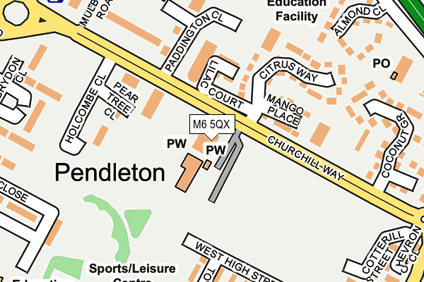
M6 5QX is located in the Pendleton & Charlestown electoral ward, within the metropolitan district of Salford and the English Parliamentary constituency of Salford and Eccles. The Sub Integrated Care Board (ICB) Location is NHS Greater Manchester ICB - 01G and the police force is Greater Manchester. This postcode has been in use since January 2011.


GetTheData
Source: OS OpenMap – Local (Ordnance Survey)
Source: OS VectorMap District (Ordnance Survey)
Licence: Open Government Licence (requires attribution)
| Easting | 381305 |
| Northing | 398805 |
| Latitude | 53.485624 |
| Longitude | -2.283203 |
GetTheData
Source: Open Postcode Geo
Licence: Open Government Licence
| Country | England |
| Postcode District | M6 |
| ➜ M6 open data dashboard ➜ See where M6 is on a map ➜ Where is Salford? | |
GetTheData
Source: Land Registry Price Paid Data
Licence: Open Government Licence
Elevation or altitude of M6 5QX as distance above sea level:
| Metres | Feet | |
|---|---|---|
| Elevation | 40m | 131ft |
Elevation is measured from the approximate centre of the postcode, to the nearest point on an OS contour line from OS Terrain 50, which has contour spacing of ten vertical metres.
➜ How high above sea level am I? Find the elevation of your current position using your device's GPS.
GetTheData
Source: Open Postcode Elevation
Licence: Open Government Licence
| Ward | Pendleton & Charlestown |
| Constituency | Salford And Eccles |
GetTheData
Source: ONS Postcode Database
Licence: Open Government Licence
| June 2021 | Violence and sexual offences | On or near Meyrick Road | 490m |
| ➜ Get more crime data in our Crime section | |||
GetTheData
Source: data.police.uk
Licence: Open Government Licence
| Churchill Way/Paddington Cl (Churchill Way) | Pendleton | 80m |
| Churchill Way/Paddington Cl (Churchill Way) | Pendleton | 92m |
| Churchill Way/Cross Ln (Churchill Way) | New Windsor | 254m |
| Churchill Way/Cross Ln (Churchill Way) | New Windsor | 290m |
| Broad St/Frederick Rd (Broad St) | Wallness | 322m |
| Langworthy (Manchester Metrolink) (Eccles New Road) | Langworthy | 1,030m |
| Anchorage (Manchester Metrolink) (Anchorage Quay) | Salford Quays | 1,247m |
| Harbour City (Manchester Metrolink) (The Quays) | The Lowry | 1,418m |
| Broadway (Manchester Metrolink) (Off Broadway) | Broadway | 1,436m |
| Mediacityuk (Manchester Metrolink) | Mediacityuk | 1,770m |
| Salford Crescent Station | 0.5km |
| Salford Central Station | 1.9km |
| Deansgate Station | 2.5km |
GetTheData
Source: NaPTAN
Licence: Open Government Licence
GetTheData
Source: ONS Postcode Database
Licence: Open Government Licence


➜ Get more ratings from the Food Standards Agency
GetTheData
Source: Food Standards Agency
Licence: FSA terms & conditions
| Last Collection | |||
|---|---|---|---|
| Location | Mon-Fri | Sat | Distance |
| Lindinis Avenue/Cavell Way | 17:30 | 11:45 | 292m |
| Strawberry Road / Broad Street | 17:30 | 11:45 | 470m |
| Salford Delivery Office | 18:00 | 12:00 | 530m |
GetTheData
Source: Dracos
Licence: Creative Commons Attribution-ShareAlike
| Facility | Distance |
|---|---|
| Clarendon Leisure Centre Liverpool Street, Salford Sports Hall, Swimming Pool, Health and Fitness Gym, Artificial Grass Pitch, Squash Courts, Studio | 271m |
| Lark Hill Community Primary School Liverpool Street, Salford Grass Pitches | 395m |
| Windsor High School (Closed) Liverpool Street, Salford Grass Pitches | 398m |
GetTheData
Source: Active Places
Licence: Open Government Licence
| School | Phase of Education | Distance |
|---|---|---|
| The New Broadwalk PRU Shaftesbury Road, Swinton, Salford, M27 5SZ | Not applicable | 273m |
| Lark Hill Community Primary School Liverpool Street, Salford, M5 4BJ | Primary | 400m |
| St Paul's CofE Primary School Cross Lane, Salford, M5 4AL | Primary | 438m |
GetTheData
Source: Edubase
Licence: Open Government Licence
The below table lists the International Territorial Level (ITL) codes (formerly Nomenclature of Territorial Units for Statistics (NUTS) codes) and Local Administrative Units (LAU) codes for M6 5QX:
| ITL 1 Code | Name |
|---|---|
| TLD | North West (England) |
| ITL 2 Code | Name |
| TLD3 | Greater Manchester |
| ITL 3 Code | Name |
| TLD34 | Greater Manchester South West |
| LAU 1 Code | Name |
| E08000006 | Salford |
GetTheData
Source: ONS Postcode Directory
Licence: Open Government Licence
The below table lists the Census Output Area (OA), Lower Layer Super Output Area (LSOA), and Middle Layer Super Output Area (MSOA) for M6 5QX:
| Code | Name | |
|---|---|---|
| OA | E00172984 | |
| LSOA | E01005655 | Salford 024A |
| MSOA | E02001180 | Salford 024 |
GetTheData
Source: ONS Postcode Directory
Licence: Open Government Licence
| M6 5BU | Churchill Way | 152m |
| M6 5DT | Holcombe Close | 153m |
| M6 5ES | Sycamore Court | 203m |
| M6 5UE | Coconut Grove | 245m |
| M6 5UF | Clementine Close | 282m |
| M6 5HL | Whitebeam Close | 304m |
| M5 4AE | Cross Lane | 330m |
| M6 5EL | Thorn Court | 341m |
| M6 5AB | Lindinis Avenue | 345m |
| M5 4AJ | Cross Lane | 368m |
GetTheData
Source: Open Postcode Geo; Land Registry Price Paid Data
Licence: Open Government Licence