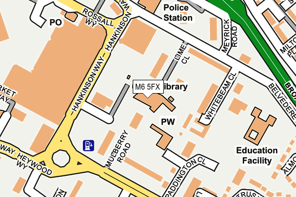
M6 5FX is located in the Pendleton & Charlestown electoral ward, within the metropolitan district of Salford and the English Parliamentary constituency of Salford and Eccles. The Sub Integrated Care Board (ICB) Location is NHS Greater Manchester ICB - 01G and the police force is Greater Manchester. This postcode has been in use since May 1994.


GetTheData
Source: OS OpenMap – Local (Ordnance Survey)
Source: OS VectorMap District (Ordnance Survey)
Licence: Open Government Licence (requires attribution)
| Easting | 381204 |
| Northing | 399108 |
| Latitude | 53.488361 |
| Longitude | -2.284742 |
GetTheData
Source: Open Postcode Geo
Licence: Open Government Licence
| Country | England |
| Postcode District | M6 |
| ➜ M6 open data dashboard ➜ See where M6 is on a map ➜ Where is Salford? | |
GetTheData
Source: Land Registry Price Paid Data
Licence: Open Government Licence
Elevation or altitude of M6 5FX as distance above sea level:
| Metres | Feet | |
|---|---|---|
| Elevation | 50m | 164ft |
Elevation is measured from the approximate centre of the postcode, to the nearest point on an OS contour line from OS Terrain 50, which has contour spacing of ten vertical metres.
➜ How high above sea level am I? Find the elevation of your current position using your device's GPS.
GetTheData
Source: Open Postcode Elevation
Licence: Open Government Licence
| Ward | Pendleton & Charlestown |
| Constituency | Salford And Eccles |
GetTheData
Source: ONS Postcode Database
Licence: Open Government Licence
| June 2021 | Violence and sexual offences | On or near Meyrick Road | 223m |
| ➜ Get more crime data in our Crime section | |||
GetTheData
Source: data.police.uk
Licence: Open Government Licence
| Churchill Way/Paddington Cl (Churchill Way) | Pendleton | 228m |
| Churchill Way/Paddington Cl (Churchill Way) | Pendleton | 246m |
| Broad St/Pendleton Church (Broad Street) | Pendleton | 297m |
| Broad St/Frederick Rd (Broad St) | Wallness | 330m |
| Broad St/Frederick Rd (Broad St) | Wallness | 347m |
| Langworthy (Manchester Metrolink) (Eccles New Road) | Langworthy | 1,148m |
| Salford Crescent Station | 0.6km |
| Salford Central Station | 2.1km |
| Deansgate Station | 2.7km |
GetTheData
Source: NaPTAN
Licence: Open Government Licence
| Percentage of properties with Next Generation Access | 0.0% |
| Percentage of properties with Superfast Broadband | 0.0% |
| Percentage of properties with Ultrafast Broadband | 0.0% |
| Percentage of properties with Full Fibre Broadband | 0.0% |
Superfast Broadband is between 30Mbps and 300Mbps
Ultrafast Broadband is > 300Mbps
| Percentage of properties unable to receive 2Mbps | 0.0% |
| Percentage of properties unable to receive 5Mbps | 0.0% |
| Percentage of properties unable to receive 10Mbps | 0.0% |
| Percentage of properties unable to receive 30Mbps | 100.0% |
GetTheData
Source: Ofcom
Licence: Ofcom Terms of Use (requires attribution)
GetTheData
Source: ONS Postcode Database
Licence: Open Government Licence


➜ Get more ratings from the Food Standards Agency
GetTheData
Source: Food Standards Agency
Licence: FSA terms & conditions
| Last Collection | |||
|---|---|---|---|
| Location | Mon-Fri | Sat | Distance |
| Strawberry Road / Broad Street | 17:30 | 11:45 | 248m |
| 34 Cresent/Hulme Place | 17:30 | 12:00 | 395m |
| Lindinis Avenue/Cavell Way | 17:30 | 11:45 | 609m |
GetTheData
Source: Dracos
Licence: Creative Commons Attribution-ShareAlike
| Facility | Distance |
|---|---|
| Puregym (Salford) Mather Way, Salford Health and Fitness Gym, Studio | 183m |
| Clarendon Leisure Centre Liverpool Street, Salford Sports Hall, Swimming Pool, Health and Fitness Gym, Artificial Grass Pitch, Squash Courts, Studio | 558m |
| Lark Hill Community Primary School Liverpool Street, Salford Grass Pitches | 559m |
GetTheData
Source: Active Places
Licence: Open Government Licence
| School | Phase of Education | Distance |
|---|---|---|
| The New Broadwalk PRU Shaftesbury Road, Swinton, Salford, M27 5SZ | Not applicable | 234m |
| Holy Family VA RC Primary School No 3 Lower Seedley Road, Salford, M6 5WX | Primary | 462m |
| Lark Hill Community Primary School Liverpool Street, Salford, M5 4BJ | Primary | 559m |
GetTheData
Source: Edubase
Licence: Open Government Licence
The below table lists the International Territorial Level (ITL) codes (formerly Nomenclature of Territorial Units for Statistics (NUTS) codes) and Local Administrative Units (LAU) codes for M6 5FX:
| ITL 1 Code | Name |
|---|---|
| TLD | North West (England) |
| ITL 2 Code | Name |
| TLD3 | Greater Manchester |
| ITL 3 Code | Name |
| TLD34 | Greater Manchester South West |
| LAU 1 Code | Name |
| E08000006 | Salford |
GetTheData
Source: ONS Postcode Directory
Licence: Open Government Licence
The below table lists the Census Output Area (OA), Lower Layer Super Output Area (LSOA), and Middle Layer Super Output Area (MSOA) for M6 5FX:
| Code | Name | |
|---|---|---|
| OA | E00028764 | |
| LSOA | E01005682 | Salford 024D |
| MSOA | E02001180 | Salford 024 |
GetTheData
Source: ONS Postcode Directory
Licence: Open Government Licence
| M6 5HL | Whitebeam Close | 122m |
| M6 5ES | Sycamore Court | 131m |
| M6 5JA | Hankinson Way | 139m |
| M6 5UN | Rossall Way | 194m |
| M6 5BU | Churchill Way | 211m |
| M6 5UJ | Heywood Way | 231m |
| M6 5FW | Pendleton Way | 287m |
| M6 5DT | Holcombe Close | 290m |
| M6 5BY | Broad Street | 300m |
| M6 5RL | Milton Place | 308m |
GetTheData
Source: Open Postcode Geo; Land Registry Price Paid Data
Licence: Open Government Licence