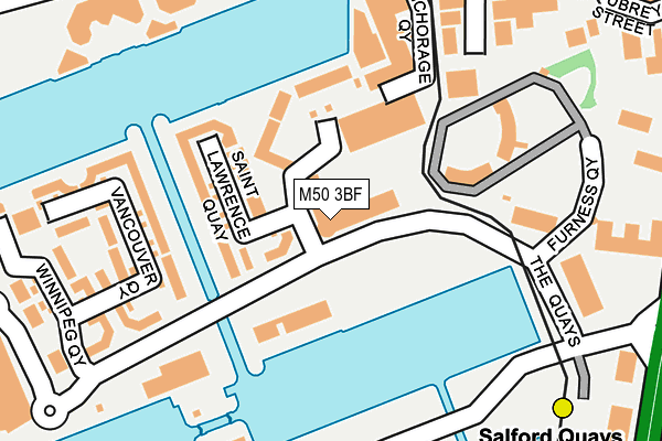
M50 3BF is located in the Quays electoral ward, within the metropolitan district of Salford and the English Parliamentary constituency of Salford and Eccles. The Sub Integrated Care Board (ICB) Location is NHS Greater Manchester ICB - 01G and the police force is Greater Manchester. This postcode has been in use since August 2004.


GetTheData
Source: OS OpenMap – Local (Ordnance Survey)
Source: OS VectorMap District (Ordnance Survey)
Licence: Open Government Licence (requires attribution)
| Easting | 381039 |
| Northing | 397304 |
| Latitude | 53.472123 |
| Longitude | -2.287120 |
GetTheData
Source: Open Postcode Geo
Licence: Open Government Licence
| Country | England |
| Postcode District | M50 |
➜ See where M50 is on a map ➜ Where is Salford? | |
GetTheData
Source: Land Registry Price Paid Data
Licence: Open Government Licence
Elevation or altitude of M50 3BF as distance above sea level:
| Metres | Feet | |
|---|---|---|
| Elevation | 30m | 98ft |
Elevation is measured from the approximate centre of the postcode, to the nearest point on an OS contour line from OS Terrain 50, which has contour spacing of ten vertical metres.
➜ How high above sea level am I? Find the elevation of your current position using your device's GPS.
GetTheData
Source: Open Postcode Elevation
Licence: Open Government Licence
| Ward | Quays |
| Constituency | Salford And Eccles |
GetTheData
Source: ONS Postcode Database
Licence: Open Government Licence
| The Quays/Ontario Basin (The Quays) | Salford Quays | 48m |
| The Quays/Ontario Basin (The Quays) | Salford Quays | 92m |
| The Quays/Winnipeg Quay (The Quays) | Salford Quays | 223m |
| The Quays/Harbour City Tram Stop (The Quays) | Salford Quays | 278m |
| The Quays/Harbour City (The Quays) | Salford Quays | 283m |
| Anchorage (Manchester Metrolink) (Anchorage Quay) | Salford Quays | 278m |
| Salford Quays (Manchester Metrolink) (St Peters Quay) | Salford Quays | 296m |
| Harbour City (Manchester Metrolink) (The Quays) | The Lowry | 392m |
| Broadway (Manchester Metrolink) (Off Broadway) | Broadway | 575m |
| Exchange Quay (Manchester Metrolink) (Exchange Quay) | Salford Quays | 626m |
| Manchester United FC Station | 1.1km |
| Salford Crescent Station | 1.8km |
| Deansgate Station | 2.4km |
GetTheData
Source: NaPTAN
Licence: Open Government Licence
GetTheData
Source: ONS Postcode Database
Licence: Open Government Licence


➜ Get more ratings from the Food Standards Agency
GetTheData
Source: Food Standards Agency
Licence: FSA terms & conditions
| Last Collection | |||
|---|---|---|---|
| Location | Mon-Fri | Sat | Distance |
| Winnipeg Quay Salford Quays | 17:30 | 12:00 | 187m |
| Dallas Court | 17:30 | 11:45 | 348m |
| Merchants Quay | 17:30 | 11:45 | 351m |
GetTheData
Source: Dracos
Licence: Creative Commons Attribution-ShareAlike
| Risk of M50 3BF flooding from rivers and sea | Low |
| ➜ M50 3BF flood map | |
GetTheData
Source: Open Flood Risk by Postcode
Licence: Open Government Licence
The below table lists the International Territorial Level (ITL) codes (formerly Nomenclature of Territorial Units for Statistics (NUTS) codes) and Local Administrative Units (LAU) codes for M50 3BF:
| ITL 1 Code | Name |
|---|---|
| TLD | North West (England) |
| ITL 2 Code | Name |
| TLD3 | Greater Manchester |
| ITL 3 Code | Name |
| TLD34 | Greater Manchester South West |
| LAU 1 Code | Name |
| E08000006 | Salford |
GetTheData
Source: ONS Postcode Directory
Licence: Open Government Licence
The below table lists the Census Output Area (OA), Lower Layer Super Output Area (LSOA), and Middle Layer Super Output Area (MSOA) for M50 3BF:
| Code | Name | |
|---|---|---|
| OA | E00172937 | |
| LSOA | E01032686 | Salford 028F |
| MSOA | E02001184 | Salford 028 |
GetTheData
Source: ONS Postcode Directory
Licence: Open Government Licence
| M50 3XU | St Lawrence Quay | 87m |
| M50 3YH | Labrador Quay | 115m |
| M50 3XT | St Lawrence Quay | 117m |
| M50 3TU | Vancouver Quay | 165m |
| M50 3TT | Vancouver Quay | 227m |
| M50 3TX | Vancouver Quay | 228m |
| M50 3SA | The Quays | 258m |
| M50 3SB | The Quays | 258m |
| M50 3SE | The Quays | 268m |
| M50 3TY | Winnipeg Quay | 290m |
GetTheData
Source: Open Postcode Geo; Land Registry Price Paid Data
Licence: Open Government Licence