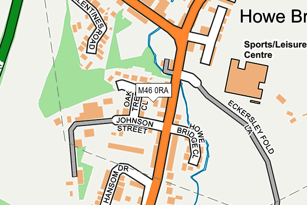
M46 0RA lies on Oak Street in Atherton, Manchester. M46 0RA is located in the Atherton South & Lilford electoral ward, within the metropolitan district of Wigan and the English Parliamentary constituency of Leigh. The Sub Integrated Care Board (ICB) Location is NHS Greater Manchester ICB - 02H and the police force is Greater Manchester. This postcode has been in use since May 1994.


GetTheData
Source: OS OpenMap – Local (Ordnance Survey)
Source: OS VectorMap District (Ordnance Survey)
Licence: Open Government Licence (requires attribution)
| Easting | 366295 |
| Northing | 402209 |
| Latitude | 53.515486 |
| Longitude | -2.509763 |
GetTheData
Source: Open Postcode Geo
Licence: Open Government Licence
| Street | Oak Street |
| Locality | Atherton |
| Town/City | Manchester |
| Country | England |
| Postcode District | M46 |
➜ See where M46 is on a map ➜ Where is Atherton? | |
GetTheData
Source: Land Registry Price Paid Data
Licence: Open Government Licence
Elevation or altitude of M46 0RA as distance above sea level:
| Metres | Feet | |
|---|---|---|
| Elevation | 40m | 131ft |
Elevation is measured from the approximate centre of the postcode, to the nearest point on an OS contour line from OS Terrain 50, which has contour spacing of ten vertical metres.
➜ How high above sea level am I? Find the elevation of your current position using your device's GPS.
GetTheData
Source: Open Postcode Elevation
Licence: Open Government Licence
| Ward | Atherton South & Lilford |
| Constituency | Leigh |
GetTheData
Source: ONS Postcode Database
Licence: Open Government Licence
| Leigh Rd/Lovers Ln (Leigh Rd) | Howe Bridge | 47m |
| Leigh Rd/Lovers Ln (Leigh Rd) | Howe Bridge | 55m |
| Lovers Ln/St Michael's Ave (Lovers Ln) | Howe Bridge | 192m |
| Leigh Rd/Caton Dr (Leigh Rd) | Howe Bridge | 212m |
| Leigh Rd/Hansom Dr (Leigh Rd) | Howe Bridge | 307m |
| Hag Fold Station | 2.3km |
| Atherton Station | 2.5km |
| Daisy Hill Station | 2.7km |
GetTheData
Source: NaPTAN
Licence: Open Government Licence
| Percentage of properties with Next Generation Access | 100.0% |
| Percentage of properties with Superfast Broadband | 100.0% |
| Percentage of properties with Ultrafast Broadband | 100.0% |
| Percentage of properties with Full Fibre Broadband | 0.0% |
Superfast Broadband is between 30Mbps and 300Mbps
Ultrafast Broadband is > 300Mbps
| Percentage of properties unable to receive 2Mbps | 0.0% |
| Percentage of properties unable to receive 5Mbps | 0.0% |
| Percentage of properties unable to receive 10Mbps | 0.0% |
| Percentage of properties unable to receive 30Mbps | 0.0% |
GetTheData
Source: Ofcom
Licence: Ofcom Terms of Use (requires attribution)
GetTheData
Source: ONS Postcode Database
Licence: Open Government Licence


➜ Get more ratings from the Food Standards Agency
GetTheData
Source: Food Standards Agency
Licence: FSA terms & conditions
| Last Collection | |||
|---|---|---|---|
| Location | Mon-Fri | Sat | Distance |
| Richmonds Drive | 17:25 | 12:00 | 1,035m |
| Tesco Crabtree M29 0ag | 17:30 | 11:30 | 1,550m |
| Howe Bridge | 17:30 | 11:30 | 1,640m |
GetTheData
Source: Dracos
Licence: Creative Commons Attribution-ShareAlike
| Risk of M46 0RA flooding from rivers and sea | Low |
| ➜ M46 0RA flood map | |
GetTheData
Source: Open Flood Risk by Postcode
Licence: Open Government Licence
The below table lists the International Territorial Level (ITL) codes (formerly Nomenclature of Territorial Units for Statistics (NUTS) codes) and Local Administrative Units (LAU) codes for M46 0RA:
| ITL 1 Code | Name |
|---|---|
| TLD | North West (England) |
| ITL 2 Code | Name |
| TLD3 | Greater Manchester |
| ITL 3 Code | Name |
| TLD36 | Greater Manchester North West |
| LAU 1 Code | Name |
| E08000010 | Wigan |
GetTheData
Source: ONS Postcode Directory
Licence: Open Government Licence
The below table lists the Census Output Area (OA), Lower Layer Super Output Area (LSOA), and Middle Layer Super Output Area (MSOA) for M46 0RA:
| Code | Name | |
|---|---|---|
| OA | E00031637 | |
| LSOA | E01006245 | Wigan 023D |
| MSOA | E02001309 | Wigan 023 |
GetTheData
Source: ONS Postcode Directory
Licence: Open Government Licence
| M46 0RP | Oak Tree Close | 51m |
| M46 0PW | Leigh Road | 53m |
| M46 0RB | Johnson Street | 69m |
| M46 0SF | Phaeton Close | 102m |
| M46 0PN | Leigh Road | 116m |
| M46 0QL | Howe Bridge Close | 120m |
| M46 0PJ | Leigh Road | 141m |
| M46 0QR | Grafton Street | 144m |
| M46 0QQ | Bedford Drive | 145m |
| M46 0PQ | Leigh Road | 157m |
GetTheData
Source: Open Postcode Geo; Land Registry Price Paid Data
Licence: Open Government Licence