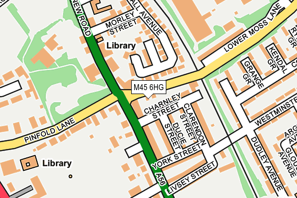
M45 6HG is located in the Besses electoral ward, within the metropolitan district of Bury and the English Parliamentary constituency of Bury South. The Sub Integrated Care Board (ICB) Location is NHS Greater Manchester ICB - 00V and the police force is Greater Manchester. This postcode has been in use since June 2001.


GetTheData
Source: OS OpenMap – Local (Ordnance Survey)
Source: OS VectorMap District (Ordnance Survey)
Licence: Open Government Licence (requires attribution)
| Easting | 380716 |
| Northing | 405732 |
| Latitude | 53.547881 |
| Longitude | -2.292505 |
GetTheData
Source: Open Postcode Geo
Licence: Open Government Licence
| Country | England |
| Postcode District | M45 |
| ➜ M45 open data dashboard ➜ See where M45 is on a map ➜ Where is Whitefield? | |
GetTheData
Source: Land Registry Price Paid Data
Licence: Open Government Licence
Elevation or altitude of M45 6HG as distance above sea level:
| Metres | Feet | |
|---|---|---|
| Elevation | 110m | 361ft |
Elevation is measured from the approximate centre of the postcode, to the nearest point on an OS contour line from OS Terrain 50, which has contour spacing of ten vertical metres.
➜ How high above sea level am I? Find the elevation of your current position using your device's GPS.
GetTheData
Source: Open Postcode Elevation
Licence: Open Government Licence
| Ward | Besses |
| Constituency | Bury South |
GetTheData
Source: ONS Postcode Database
Licence: Open Government Licence
| Bury New Rd/Moss Ln (Bury New Rd) | Whitefield | 97m |
| Bury New Rd/Moss Ln (Bury New Rd) | Whitefield | 105m |
| Bury New Rd/Sefton St (Bury New Rd) | Besses O Th Barn | 234m |
| Bury New Rd/Hamilton Rd (Bury New Rd) | Whitefield | 272m |
| Bury New Rd/Hamilton Rd (Bury New Rd) | Whitefield | 296m |
| Whitefield (Manchester Metrolink) (Bury New Road) | Whitefield | 416m |
| Besses O'th'barn (Manchester Metrolink) (Off Bury Old Road) | Besses O Th Barn | 772m |
| Clifton (Manchester) Station | 3.2km |
| Swinton (Manchester) Station | 4.7km |
| Moorside Station | 5.3km |
GetTheData
Source: NaPTAN
Licence: Open Government Licence
GetTheData
Source: ONS Postcode Database
Licence: Open Government Licence


➜ Get more ratings from the Food Standards Agency
GetTheData
Source: Food Standards Agency
Licence: FSA terms & conditions
| Last Collection | |||
|---|---|---|---|
| Location | Mon-Fri | Sat | Distance |
| Whitefield Station | 17:30 | 12:00 | 588m |
| 279a Bury New Road | 17:30 | 12:00 | 626m |
| Kenmore Road | 17:30 | 11:45 | 818m |
GetTheData
Source: Dracos
Licence: Creative Commons Attribution-ShareAlike
| Facility | Distance |
|---|---|
| Besses Playing Field (Victoria Park) Livsey Street, Whitefield, Manchester Grass Pitches | 247m |
| Higher Lane Primary School Egerton Road, Whitefield, Manchester Grass Pitches, Sports Hall | 305m |
| Stand Cricket Club Hamilton Road, Whitefield, Manchester Grass Pitches | 430m |
GetTheData
Source: Active Places
Licence: Open Government Licence
| School | Phase of Education | Distance |
|---|---|---|
| Higher Lane Primary School Egerton Road, Whitefield, Manchester, M45 7EX | Primary | 305m |
| Philips High School Higher Lane, Whitefield, Manchester, M45 7PH | Secondary | 494m |
| Whitefield Community Primary School Victoria Avenue, Whitefield, Manchester, M45 6DP | Primary | 571m |
GetTheData
Source: Edubase
Licence: Open Government Licence
The below table lists the International Territorial Level (ITL) codes (formerly Nomenclature of Territorial Units for Statistics (NUTS) codes) and Local Administrative Units (LAU) codes for M45 6HG:
| ITL 1 Code | Name |
|---|---|
| TLD | North West (England) |
| ITL 2 Code | Name |
| TLD3 | Greater Manchester |
| ITL 3 Code | Name |
| TLD37 | Greater Manchester North East |
| LAU 1 Code | Name |
| E08000002 | Bury |
GetTheData
Source: ONS Postcode Directory
Licence: Open Government Licence
The below table lists the Census Output Area (OA), Lower Layer Super Output Area (LSOA), and Middle Layer Super Output Area (MSOA) for M45 6HG:
| Code | Name | |
|---|---|---|
| OA | E00025245 | |
| LSOA | E01004986 | Bury 020B |
| MSOA | E02001038 | Bury 020 |
GetTheData
Source: ONS Postcode Directory
Licence: Open Government Licence
| M45 6BG | Charnley Street | 39m |
| M45 6QE | Moss Lane | 40m |
| M45 6QZ | Nuttall Mews | 78m |
| M45 6AD | Bury New Road | 83m |
| M45 6AH | Ducie Street | 87m |
| M45 6QF | Bury New Road | 113m |
| M45 6AF | Clarendon Street | 115m |
| M45 6GE | Bury New Road | 132m |
| M45 6AB | Bury New Road | 142m |
| M45 6BF | Knowsley Road | 143m |
GetTheData
Source: Open Postcode Geo; Land Registry Price Paid Data
Licence: Open Government Licence