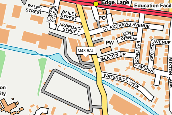
M43 6AU is located in the Clayton & Openshaw electoral ward, within the metropolitan district of Manchester and the English Parliamentary constituency of Manchester Central. The Sub Integrated Care Board (ICB) Location is NHS Greater Manchester ICB - 14L and the police force is Greater Manchester. This postcode has been in use since May 1994.


GetTheData
Source: OS OpenMap – Local (Ordnance Survey)
Source: OS VectorMap District (Ordnance Survey)
Licence: Open Government Licence (requires attribution)
| Easting | 389071 |
| Northing | 398066 |
| Latitude | 53.479202 |
| Longitude | -2.166144 |
GetTheData
Source: Open Postcode Geo
Licence: Open Government Licence
| Country | England |
| Postcode District | M43 |
| ➜ M43 open data dashboard ➜ See where M43 is on a map ➜ Where is Manchester? | |
GetTheData
Source: Land Registry Price Paid Data
Licence: Open Government Licence
Elevation or altitude of M43 6AU as distance above sea level:
| Metres | Feet | |
|---|---|---|
| Elevation | 90m | 295ft |
Elevation is measured from the approximate centre of the postcode, to the nearest point on an OS contour line from OS Terrain 50, which has contour spacing of ten vertical metres.
➜ How high above sea level am I? Find the elevation of your current position using your device's GPS.
GetTheData
Source: Open Postcode Elevation
Licence: Open Government Licence
| Ward | Clayton & Openshaw |
| Constituency | Manchester Central |
GetTheData
Source: ONS Postcode Database
Licence: Open Government Licence
| June 2022 | Violence and sexual offences | On or near Rainow Avenue | 340m |
| ➜ Get more crime data in our Crime section | |||
GetTheData
Source: data.police.uk
Licence: Open Government Licence
| Edge Ln/Manchester Rd (Edge Ln) | Droylsden | 106m |
| Edge Ln/Wheler St (Edge Ln) | Droylsden | 178m |
| Edge Lane Tram Stop (Manchester Road) | Droylsden | 185m |
| Edge Ln/Wheler St (Edge Ln) | Droylsden | 198m |
| Edge Lane Tram Stop (Manchester Rd) | Droylsden | 213m |
| Edge Lane (Manchester Metrolink) (Manchester Road) | Droylsden | 193m |
| Cemetery Road (Manchester Metrolink) (Manchester Road) | Droylsden | 742m |
| Clayton Hall (Manchester Metrolink) (Ashton New Road) | Clayton | 1,135m |
| Droylsden (Manchester Metrolink) (Ashton Road) | Droylsden | 1,425m |
| Gorton Station | 1.1km |
| Fairfield Station | 1.6km |
| Ashburys Station | 2.1km |
GetTheData
Source: NaPTAN
Licence: Open Government Licence
GetTheData
Source: ONS Postcode Database
Licence: Open Government Licence


➜ Get more ratings from the Food Standards Agency
GetTheData
Source: Food Standards Agency
Licence: FSA terms & conditions
| Last Collection | |||
|---|---|---|---|
| Location | Mon-Fri | Sat | Distance |
| Opp 123 Sandywell Street | 17:30 | 12:00 | 385m |
| 42 Wheeler Street | 17:30 | 12:00 | 483m |
| 120 Lumb Lane | 17:30 | 12:00 | 625m |
GetTheData
Source: Dracos
Licence: Creative Commons Attribution-ShareAlike
| Facility | Distance |
|---|---|
| Copperas Lane Playing Fields Copperas Lane, Droylsden Grass Pitches | 580m |
| Hewlett Johnson Playing Fields Edge Lane, Droylsden Grass Pitches | 616m |
| Sunnybank Park Lewis Road, Droylsden, Manchester Grass Pitches, Artificial Grass Pitch | 616m |
GetTheData
Source: Active Places
Licence: Open Government Licence
| School | Phase of Education | Distance |
|---|---|---|
| Higher Openshaw Community School Saunton Road, Higher Openshaw, Manchester, M11 1AJ | Primary | 351m |
| Manchester Road Primary Academy Manchester Road, Droylsden, Manchester, M43 6GD | Primary | 463m |
| Seymour Road Academy Seymour Road South, Manchester, M11 4PR | Primary | 542m |
GetTheData
Source: Edubase
Licence: Open Government Licence
The below table lists the International Territorial Level (ITL) codes (formerly Nomenclature of Territorial Units for Statistics (NUTS) codes) and Local Administrative Units (LAU) codes for M43 6AU:
| ITL 1 Code | Name |
|---|---|
| TLD | North West (England) |
| ITL 2 Code | Name |
| TLD3 | Greater Manchester |
| ITL 3 Code | Name |
| TLD33 | Manchester |
| LAU 1 Code | Name |
| E08000003 | Manchester |
GetTheData
Source: ONS Postcode Directory
Licence: Open Government Licence
The below table lists the Census Output Area (OA), Lower Layer Super Output Area (LSOA), and Middle Layer Super Output Area (MSOA) for M43 6AU:
| Code | Name | |
|---|---|---|
| OA | E00025786 | |
| LSOA | E01005094 | Manchester 012B |
| MSOA | E02001056 | Manchester 012 |
GetTheData
Source: ONS Postcode Directory
Licence: Open Government Licence
| M43 6BH | Merton Drive | 116m |
| M43 6BS | Edge Lane | 118m |
| M11 4PH | Arbroath Street | 126m |
| M43 6BG | Edge Lane | 134m |
| M11 4PJ | Bailey Street | 146m |
| M43 6BW | Kent Avenue | 146m |
| M43 6BP | St Andrews Avenue | 162m |
| M11 4RS | Howgill Street | 174m |
| M43 6QF | Manchester Road | 184m |
| M43 6JE | Manchester Road | 192m |
GetTheData
Source: Open Postcode Geo; Land Registry Price Paid Data
Licence: Open Government Licence