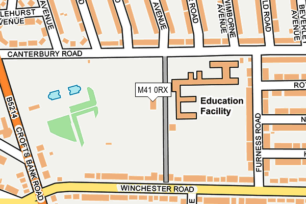
M41 0RX is located in the Urmston electoral ward, within the metropolitan district of Trafford and the English Parliamentary constituency of Stretford and Urmston. The Sub Integrated Care Board (ICB) Location is NHS Greater Manchester ICB - 02A and the police force is Greater Manchester. This postcode has been in use since May 1994.


GetTheData
Source: OS OpenMap – Local (Ordnance Survey)
Source: OS VectorMap District (Ordnance Survey)
Licence: Open Government Licence (requires attribution)
| Easting | 376779 |
| Northing | 395303 |
| Latitude | 53.453966 |
| Longitude | -2.351148 |
GetTheData
Source: Open Postcode Geo
Licence: Open Government Licence
| Country | England |
| Postcode District | M41 |
| ➜ M41 open data dashboard ➜ See where M41 is on a map ➜ Where is Urmston? | |
GetTheData
Source: Land Registry Price Paid Data
Licence: Open Government Licence
Elevation or altitude of M41 0RX as distance above sea level:
| Metres | Feet | |
|---|---|---|
| Elevation | 20m | 66ft |
Elevation is measured from the approximate centre of the postcode, to the nearest point on an OS contour line from OS Terrain 50, which has contour spacing of ten vertical metres.
➜ How high above sea level am I? Find the elevation of your current position using your device's GPS.
GetTheData
Source: Open Postcode Elevation
Licence: Open Government Licence
| Ward | Urmston |
| Constituency | Stretford And Urmston |
GetTheData
Source: ONS Postcode Database
Licence: Open Government Licence
| January 2022 | Other theft | On or near Tiverton Road | 477m |
| ➜ Get more crime data in our Crime section | |||
GetTheData
Source: data.police.uk
Licence: Open Government Licence
| Canterbury Road/Davyhulme Park (Canterbury Road) | Davyhulme | 200m |
| Winchester Road/Crofts Bank Road (Winchester Road) | Urmston | 236m |
| Crofts Bank Road/Moorside Road East (Crofts Bank Rd) | Urmston | 275m |
| Crofts Bank Road/Canterbury Road (Crofts Bank Rd) | Davyhulme | 295m |
| Crofts Bank Road/Moorside Road (Crofts Bank Rd) | Urmston | 305m |
| Urmston Station | 0.7km |
| Chassen Road Station | 1.4km |
| Humphrey Park Station | 1.6km |
GetTheData
Source: NaPTAN
Licence: Open Government Licence
GetTheData
Source: ONS Postcode Database
Licence: Open Government Licence


➜ Get more ratings from the Food Standards Agency
GetTheData
Source: Food Standards Agency
Licence: FSA terms & conditions
| Last Collection | |||
|---|---|---|---|
| Location | Mon-Fri | Sat | Distance |
| Moorside Road East | 17:30 | 11:30 | 343m |
| Romley Road / Lostock Road | 17:30 | 11:30 | 384m |
| Canterbury Road P.o. | 17:30 | 12:00 | 398m |
GetTheData
Source: Dracos
Licence: Creative Commons Attribution-ShareAlike
| Facility | Distance |
|---|---|
| Davyhulme Park Canterbury Road, Urmston, Manchester Outdoor Tennis Courts | 9m |
| Davyhulme Primary School Canterbury Road, Urmston, Manchester Grass Pitches | 62m |
| Anytime Fitness (Urmston) Flixton Road, Urmston, Manchester Health and Fitness Gym, Studio | 618m |
GetTheData
Source: Active Places
Licence: Open Government Licence
| School | Phase of Education | Distance |
|---|---|---|
| Davyhulme Primary School Canterbury Road, Urmston, Manchester, M41 0RX | Primary | 0m |
| Urmston Primary School Wycliffe Road, Urmston, Manchester, M41 5AH | Primary | 705m |
| Our Lady of the Rosary RC Primary School Davyhulme Road, Davyhulme, Urmston, Manchester, M41 7DS | Primary | 737m |
GetTheData
Source: Edubase
Licence: Open Government Licence
The below table lists the International Territorial Level (ITL) codes (formerly Nomenclature of Territorial Units for Statistics (NUTS) codes) and Local Administrative Units (LAU) codes for M41 0RX:
| ITL 1 Code | Name |
|---|---|
| TLD | North West (England) |
| ITL 2 Code | Name |
| TLD3 | Greater Manchester |
| ITL 3 Code | Name |
| TLD34 | Greater Manchester South West |
| LAU 1 Code | Name |
| E08000009 | Trafford |
GetTheData
Source: ONS Postcode Directory
Licence: Open Government Licence
The below table lists the Census Output Area (OA), Lower Layer Super Output Area (LSOA), and Middle Layer Super Output Area (MSOA) for M41 0RX:
| Code | Name | |
|---|---|---|
| OA | E00031006 | |
| LSOA | E01006117 | Trafford 002B |
| MSOA | E02001260 | Trafford 002 |
GetTheData
Source: ONS Postcode Directory
Licence: Open Government Licence
| M41 0RH | Canterbury Road | 119m |
| M41 0UG | Winchester Road | 151m |
| M41 0PT | Canterbury Road | 187m |
| M41 0UQ | Furness Road | 194m |
| M41 0UJ | Winchester Road | 196m |
| M41 0RT | Wimborne Avenue | 218m |
| M41 0RL | Rochester Road | 225m |
| M41 0UX | Rowan Avenue | 228m |
| M41 0UY | Sylvan Avenue | 231m |
| M41 0RS | Rochester Road | 231m |
GetTheData
Source: Open Postcode Geo; Land Registry Price Paid Data
Licence: Open Government Licence