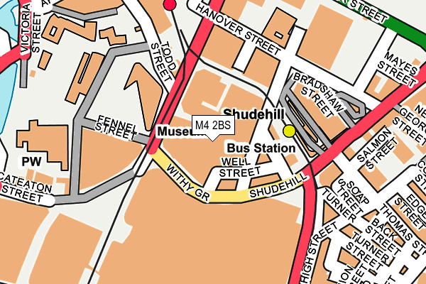
M4 2BS lies on Withy Grove in Manchester. M4 2BS is located in the Piccadilly electoral ward, within the metropolitan district of Manchester and the English Parliamentary constituency of Manchester Central. The Sub Integrated Care Board (ICB) Location is NHS Greater Manchester ICB - 14L and the police force is Greater Manchester. This postcode has been in use since January 1980.


GetTheData
Source: OS OpenMap – Local (Ordnance Survey)
Source: OS VectorMap District (Ordnance Survey)
Licence: Open Government Licence (requires attribution)
| Easting | 384120 |
| Northing | 398744 |
| Latitude | 53.485169 |
| Longitude | -2.240778 |
GetTheData
Source: Open Postcode Geo
Licence: Open Government Licence
| Street | Withy Grove |
| Town/City | Manchester |
| Country | England |
| Postcode District | M4 |
| ➜ M4 open data dashboard ➜ See where M4 is on a map ➜ Where is Manchester? | |
GetTheData
Source: Land Registry Price Paid Data
Licence: Open Government Licence
Elevation or altitude of M4 2BS as distance above sea level:
| Metres | Feet | |
|---|---|---|
| Elevation | 40m | 131ft |
Elevation is measured from the approximate centre of the postcode, to the nearest point on an OS contour line from OS Terrain 50, which has contour spacing of ten vertical metres.
➜ How high above sea level am I? Find the elevation of your current position using your device's GPS.
GetTheData
Source: Open Postcode Elevation
Licence: Open Government Licence
| Ward | Piccadilly |
| Constituency | Manchester Central |
GetTheData
Source: ONS Postcode Database
Licence: Open Government Licence
| December 2021 | Violence and sexual offences | On or near Brown Street | 485m |
| August 2021 | Violence and sexual offences | On or near Victoria Bridge Street | 376m |
| ➜ Withy Grove crime map and outcomes | |||
GetTheData
Source: data.police.uk
Licence: Open Government Licence
| Corporation St/Printworks (Corporation St) | Manchester City Centre | 69m |
| Corporation Street (Corporation St) | Manchester City Centre | 89m |
| Victoria Stn Approach (Todd Street) | Manchester City Centre | 124m |
| Victoria Station (Todd Street) | Manchester City Centre | 133m |
| Todd St/Football Museum (Todd St) | Manchester City Centre | 146m |
| Shudehill (Manchester Metrolink) (Shudehill) | Manchester City Centre | 139m |
| Exchange Square (Manchester Metrolink) (Corporation St) | Manchester City Centre | 149m |
| Victoria (Manchester Metrolink) (Off Corporation Street) | Manchester City Centre | 254m |
| Market Street (Manchester Metrolink) (Market Street) | Manchester City Centre | 377m |
| Piccadilly Gardens (Manchester Metrolink) (Portland Street) | Piccadilly Gardens | 635m |
| Manchester Victoria Station | 0.3km |
| Salford Central Station | 1km |
| Manchester Piccadilly Station | 1.1km |
GetTheData
Source: NaPTAN
Licence: Open Government Licence
| Median download speed | 15.9Mbps |
| Average download speed | 14.0Mbps |
| Maximum download speed | 22.00Mbps |
| Median upload speed | 1.1Mbps |
| Average upload speed | 1.0Mbps |
| Maximum upload speed | 1.26Mbps |
GetTheData
Source: Ofcom
Licence: Ofcom Terms of Use (requires attribution)
GetTheData
Source: ONS Postcode Database
Licence: Open Government Licence


➜ Get more ratings from the Food Standards Agency
GetTheData
Source: Food Standards Agency
Licence: FSA terms & conditions
| Last Collection | |||
|---|---|---|---|
| Location | Mon-Fri | Sat | Distance |
| Long Mill Gate P.o. | 19:00 | 12:00 | 157m |
| Nicholas Croft | 19:00 | 12:00 | 188m |
| Victoria Station, Platform 11 | 19:00 | 12:00 | 239m |
GetTheData
Source: Dracos
Licence: Creative Commons Attribution-ShareAlike
| Facility | Distance |
|---|---|
| Nuffield Health (Manchester) Withy Grove, Manchester Swimming Pool, Health and Fitness Gym, Studio | 0m |
| Chetham's School Of Music Long Millgate, Manchester Swimming Pool, Health and Fitness Gym, Squash Courts | 198m |
| Fitness Exchange (Manchester) (Closed) Church Street, Manchester Studio, Health and Fitness Gym | 268m |
GetTheData
Source: Active Places
Licence: Open Government Licence
| School | Phase of Education | Distance |
|---|---|---|
| Digital Advantage Hanover Street, Manchester, M60 0AS | Not applicable | 169m |
| The Cooperative College Holyoake House, Hanover Street, Manchester, M60 0AS | Not applicable | 169m |
| Chetham's School of Music Long Millgate, Manchester, M3 1SB | Not applicable | 198m |
GetTheData
Source: Edubase
Licence: Open Government Licence
The below table lists the International Territorial Level (ITL) codes (formerly Nomenclature of Territorial Units for Statistics (NUTS) codes) and Local Administrative Units (LAU) codes for M4 2BS:
| ITL 1 Code | Name |
|---|---|
| TLD | North West (England) |
| ITL 2 Code | Name |
| TLD3 | Greater Manchester |
| ITL 3 Code | Name |
| TLD33 | Manchester |
| LAU 1 Code | Name |
| E08000003 | Manchester |
GetTheData
Source: ONS Postcode Directory
Licence: Open Government Licence
The below table lists the Census Output Area (OA), Lower Layer Super Output Area (LSOA), and Middle Layer Super Output Area (MSOA) for M4 2BS:
| Code | Name | |
|---|---|---|
| OA | E00175846 | |
| LSOA | E01033664 | Manchester 054D |
| MSOA | E02006902 | Manchester 054 |
GetTheData
Source: ONS Postcode Directory
Licence: Open Government Licence
| M4 2BJ | Withy Grove | 60m |
| M4 2AF | Shudehill | 85m |
| M4 1EZ | Shudehill | 173m |
| M4 1FS | High Street | 192m |
| M60 0AE | Redfearn Street | 201m |
| M4 1DH | Thomas Street | 210m |
| M4 1EU | Thomas Street | 224m |
| M4 4AA | Shudehill | 231m |
| M4 1DY | Turner Street | 232m |
| M4 1ED | High Street | 235m |
GetTheData
Source: Open Postcode Geo; Land Registry Price Paid Data
Licence: Open Government Licence